Mongolata, South Australia

Last updated

Mongolata
South Australia
CSIRO ScienceImage 4228 Old mine adit at the abandoned Mongolata Goldfield 30km northeast of Burra in South Australia 1989.jpg
Population7 (SAL 2021) [1]
Postcode(s) 5417 [2]
LGA(s) Regional Council of Goyder
State electorate(s) Stuart [2]
Federal division(s) Grey [2]
Localities around Mongolata:
Mount Bryan East Mount Bryan East
Burra Eastern Districts
Burra Mongolata Burra Eastern Districts
Baldina Baldina Burra Eastern Districts
FootnotesCoordinates [3]
View towards mine workings of the Mongolata goldfield Mongolata goldfield-5.JPG
View towards mine workings of the Mongolata goldfield
Native gold on goethite from the Mongolata goldfield Mongolata gold.JPG
Native gold on goethite from the Mongolata goldfield

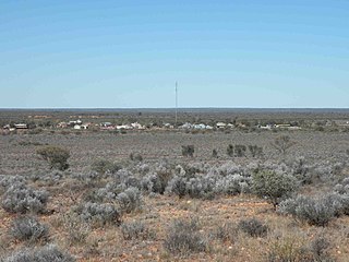
Mongolata is a rural locality in the Mid North region of South Australia, situated in the Regional Council of Goyder. [2] The modern locality was established in August 2000, when boundaries were formalised for the "long established local name". [3]

The Hundred of Mongolata was proclaimed by Governor Anthony Musgrave on 30 December 1875, derived from an Aboriginal name. [2] Mongolata Post Office opened on 1 April 1878 and closed on 31 December 1946. [4] A government town named "Tracy" near the Poonunda Homestead was surveyed in June 1881, but was not successful and was incorporated into the broader Mongolata locality. The modern locality is smaller than the cadastral hundred on the northern, western and eastern sides. [2]

It was settled as a farming area, with the first residents planting potatoes and then later barley; however, they often struggled for lack of rain. A school was established in the late 1800s, but closed in 1898. [5] Gold was discovered at Mongolata in 1930, and at its peak 120 men worked on the field. A government battery and cyanide plant were completed in 1932 and opened in March 1933. Attempts were made to reopen a school at Mongolata for the mining families in 1935–1936, but this was unsuccessful. [6] [7] Most miners had left by the end of 1936, but the largest mine on the field, the Byles' Mine, remained in operation, operating until 1954, when both the mine and battery closed. [8] [9]

The field produced about 11,000oz of gold extracted from 7,749t of ore. Byles mine was the most significant producer with 3.900oz, followed by Takati (2,900oz)and Baldina (1,400oz) mines. Especially Takati was known for rich specimen gold, the largest piece weighing 216oz. [10] Gold was almost entirely extracted from a stockwork-type mineralisation within the Neoproterozoic Cox sandstone. The quartz veins are rich in goethite, often pseudomorph after siderite. Native gold is mostly associated with goethite. Alluvial mining along the range front of the Mongolata goldfield remained largely unsuccessful.

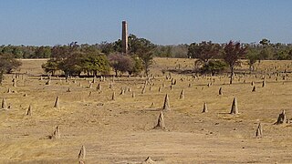
The historic Mongolata Goldfield Ruins, including the remnants of the cyanide works, eating house, dugouts and former Byles' Mine, are located off Mongolata Road and listed on the South Australian Heritage Register. The goldfield is significant as one of only two established in South Australia during the Great Depression. [2]

Related Research Articles

<span class="mw-page-title-main">Burra, South Australia</span> Town in South Australia

Burra is a pastoral centre and historic tourist town in the mid-north of South Australia. It lies east of the Clare Valley in the Bald Hills range, part of the northern Mount Lofty Ranges, and on Burra Creek. The town began as a single company mining township that, by 1851, was a set of townships collectively known as "The Burra". The Burra mines supplied 89% of South Australia's and 5% of the world's copper for 15 years, and the settlement has been credited with saving the economy of the struggling new colony of South Australia. The Burra Burra Copper Mine was established in 1848 mining the copper deposit discovered in 1845. Miners and townspeople migrated to Burra primarily from Cornwall, Wales, Scotland and Germany. The mine first closed in 1877, briefly opened again early in the 20th century and for a last time from 1970 to 1981.

<span class="mw-page-title-main">Tarcoola, South Australia</span> Town in South Australia

Tarcoola is a town in the Far North of South Australia 416 kilometres (258 mi) north-northwest of Port Augusta. At the 2016 census, Tarcoola had no people living within its boundaries.

Boogardie is an abandoned town in the Mid West region of Western Australia.

<span class="mw-page-title-main">Cumberland, Queensland</span> Town in Queensland, Australia

Cumberland is a ghost town in the Shire of Etheridge in Queensland, Australia, located approximately 20 kilometres (12 mi) west of Georgetown, Queensland on the Gulf Developmental Road.

Burra was an electoral district of the House of Assembly in the Australian state of South Australia from 1875 to 1902, and again from 1938 to 1970.

<span class="mw-page-title-main">Arltunga Historical Reserve</span> Protected area in the Northern Territory, Australia

Arltunga Historical Reserve, known also as Arnerre-ntyenge is a deserted gold rush town located in the Northern Territory of Australia in the locality of Hart about 110 kilometres (68 mi) east of Alice Springs. It is on the lands of the Eastern Arrernte people who are the Traditional Owners.

<span class="mw-page-title-main">District Council of Burra Burra</span> Local government area in South Australia

The District Council of Burra Burra was a local government area in South Australia from 1935 to 1997.

Burra Eastern Districts is a rural locality in the Mid North region of South Australia, situated in the Regional Council of Goyder. It was established in August 2000, when boundaries were formalised for the "long established local name".

Apoinga is a rural locality in the Mid North region of South Australia, situated in the Regional Council of Goyder.

<span class="mw-page-title-main">County of Burra</span> Cadastral in South Australia

County of Burra is a cadastral unit located in the Australian state of South Australia which covers land located in the state’s east associated with the town of Burra. It was proclaimed in 1851 by Governor Young and named after the town of Burra.

The Corporate Town of Burra was a local government area in South Australia from 1876 to 1969.

Baldina is a rural locality in the Mid North region of South Australia, situated in the Regional Council of Goyder. It was established in August 2000, when boundaries were formalised for the "long established local name".

Koonoona is a rural locality in the Mid North region of South Australia, situated in the Regional Council of Goyder. It was established in August 2000, when boundaries were formalised for the "long established local name". It occupies the north-western corner of the cadastral Hundred of Apoinga.

Gum Creek is a rural locality in the Mid North region of South Australia, situated in the Regional Council of Goyder. It was established in August 2000, when boundaries were formalised for the "long established local name". It is named for the Gum Creek pastoral property, which originally extended from Farrell Flat to Mount Bryan, with the homestead being located in the Gum Creek locality. The property was owned by a number of notable figures, with Sir John Duncan succeeding Sir Walter Hughes as owner.

North Booborowie is a rural locality in the Mid North region of South Australia, situated in the Regional Council of Goyder. It was established in August 2008, when boundaries were formalised for the "long established local name". In early days, the North Booborowie name was sometimes used synonymously with Willalo, which is now gazetted as a separate locality to its north.

Leighton is a rural locality in the Mid North region of South Australia, situated in the Regional Council of Goyder. It was established in August 2000, when boundaries were formalised for the "long established local name".

Targinnie is a coastal locality in the Gladstone Region, Queensland, Australia. In the 2021 census, Targinnie had a population of 31 people.

<span class="mw-page-title-main">Ravenswood Mining Landscape and Chinese Settlement Area</span> Historic site in Queensland, Australia

Ravenswood Mining Landscape and Chinese Settlement Area is a heritage-listed former mining town and archaeological site on the reserve bounded by School Street, Cemetery Road, Railway Street and Burdekin Falls Dam Road, Ravenswood, Charters Towers Region, Queensland, Australia. It was added to the Queensland Heritage Register on 14 October 2016.

Monal is a locality in the North Burnett Region, Queensland, Australia. In the 2021 census, Monal had a population of 34 people.

Reno is a rural locality in the Cootamundra–Gundagai Regional Council local government area of the Riverina region, of New South Wales, Australia. There was once a gold mining village of the same name. For many years, until at least 2016, the locality was known as Jones Creek. Its population at the 2021 census was 131.

References

  1. Australian Bureau of Statistics (28 June 2022). "Mongolata (suburb and locality)". Australian Census 2021 QuickStats. Retrieved 28 June 2022.  OOjs UI icon edit-ltr-progressive.svg
  2. 1 2 3 4 5 6 7 "Search result(s) for Mongolata, 5417". Location SA Map Viewer. Government of South Australia. Retrieved 16 February 2016.
  3. 1 2 "Search result(s) for Mongolata, 5417". Property Location Browser. Government of South Australia. Archived from the original on 12 October 2016. Retrieved 17 February 2016.
  4. "Mongolata". Premier Postal. Post Office Reference. Retrieved 29 April 2016.
  5. "THE EDUCATION DEPARTMENT". Evening Journal (Adelaide) . Vol. XXX, no. 8748. South Australia. 12 December 1898. p. 2. Retrieved 29 April 2016 via National Library of Australia.
  6. "SCHOOL AT MONGOLATA". Burra Record . Vol. 56, no. 39. South Australia. 24 September 1935. p. 2. Retrieved 29 April 2016 via National Library of Australia.
  7. "MONGOLATA". Burra Record . Vol. 57, no. 14. South Australia. 7 April 1936. p. 1. Retrieved 29 April 2016 via National Library of Australia.
  8. "Mongolata Goldfield". Flinders Ranges Research. Retrieved 29 April 2016.
  9. "Mongolata Gold Mine". Postcards SA. Retrieved 29 April 2016.
  10. Drew, G.J., 2004. Goldfields of South Australia. Department of Primary Industries and Resources. Special Publication 12.

33°34′S139°06′E / 33.567°S 139.100°E / -33.567; 139.100