
Norwood is a suburb of Adelaide, about 4 km (2.5 mi) east of the Adelaide city centre. The suburb is in the City of Norwood Payneham & St Peters, whose predecessor was the oldest South Australian local government municipality.
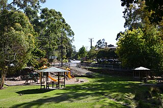
Bridgewater is a town in South Australia, located in the Adelaide Hills to the south-east of the Adelaide city centre.
Penfield is a northern suburb of Adelaide, South Australia, in the City of Playford.

Wallaroo Mines is a suburb of the inland town of Kadina on the Yorke Peninsula in the Copper Coast Council area. It was named for the land division in which it was established in 1860, the Hundred of Wallaroo, as was the nearby coastal town of Wallaroo. The boundaries were formally gazetted in January 1999 for "the long established name".
Whites Flat is a rural locality in the Eyre and Western region of South Australia, situated within the District Council of Lower Eyre Peninsula. The boundaries for the locality were formally established in October 2003 for the long established local name; this had originally been named after pastoralist Samuel White.

Belalie East is a rural locality in the Mid North region of South Australia. It is situated in the Northern Areas Council. The boundaries were formally established in April 2001 for the long established local name, relating to the cadastral Hundred of Belalie; however, the modern locality is divided between Belalie and the adjacent Hundred of Whyte.

Long Plains is a rural locality and small township on the northern Adelaide Plains in South Australia, 73 km north of Adelaide. It is divided between the Wakefield Regional Council and the Adelaide Plains Council. The formal boundaries were established in 1997 for the long established local name with respect of the section in the Adelaide Plains Council; the portion in the Wakefield Council was added in January 2000.
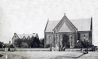
Christ Church, North Adelaide is an Anglican church on Acre 745 which lays between Jeffcott Street and 36-40 Palmer Place, North Adelaide, South Australia, Australia. The foundation stone was laid on 1 June 1848 by Augustus Short, the first Bishop of Adelaide; and the church was consecrated in 1849. Christ Church was the pro-cathedral until 1877 when St Peter's Cathedral opened.
Baldina is a rural locality in the Mid North region of South Australia, situated in the Regional Council of Goyder. It was established in August 2000, when boundaries were formalised for the "long established local name".
Franklyn is a rural locality in the Mid North region of South Australia, situated in the Regional Council of Goyder. It was established in August 2000, when boundaries were formalised for the "long established local name". It comprises the northern section of the cadastral Hundred of Wonna. The name stems from a Franklyn House in Devonshire.
Emu Downs is a rural locality in the Mid North region of South Australia, situated in the Regional Council of Goyder.
Ngapala is a rural locality in the Mid North region of South Australia, situated in the Regional Council of Goyder. It was established in August 2000, when boundaries were formalised for the "long established local name". It is divided between the cadastral Hundreds of English and Julia Creek.
Buchanan is a rural locality in the Mid North region of South Australia, situated in the Regional Council of Goyder. It was established in August 2000, when boundaries were formalised for the "long established local name".
Gum Creek is a rural locality in the Mid North region of South Australia, situated in the Regional Council of Goyder. It was established in August 2000, when boundaries were formalised for the "long established local name". It is named for the Gum Creek pastoral property, which originally extended from Farrell Flat to Mount Bryan, with the homestead being located in the Gum Creek locality. The property was owned by a number of notable figures, with Sir John Duncan succeeding Sir Walter Hughes as owner.
Willalo is a rural locality in the Mid North region of South Australia, situated in the Regional Council of Goyder. It was established in August 2000, when boundaries were formalised for the "long established local name". It was also known in its early days as North Booboorowie.
Leighton is a rural locality in the Mid North region of South Australia, situated in the Regional Council of Goyder. It was established in August 2000, when boundaries were formalised for the "long established local name".
Mercunda is a town and a locality in the Australian state of South Australia located in the state's south-east about 134 kilometres (83 mi) east of the state capital of Adelaide, and about 52 kilometres (32 mi) north-east and about 53 kilometres (33 mi) south-west respectively of the municipal seats of Karoonda and Loxton.
Targinnie is a coastal locality in the Gladstone Region, Queensland, Australia. In the 2021 census, Targinnie had a population of 31 people.

Junabee is a rural locality in the Southern Downs Region, Queensland, Australia. In the 2016 census, Junabee had a population of 213 people.
Josiah Eustace Dodd was an Australian pipe organ builder, based in Adelaide.

