
Scone is a town in the Upper Hunter Shire in the Hunter Region of New South Wales, Australia. At the 2021 census, Scone had a population of 5,013 people. It is on the New England Highway north of Muswellbrook about 270 kilometres north of Sydney, and is part of the New England (federal) and Upper Hunter (state) electorates. Scone is in a farming area and is also noted for breeding Thoroughbred racehorses. It is known as the 'Horse capital of Australia'.

Victor Harbor is a town in the Australian state of South Australia located within the City of Victor Harbor on the south coast of the Fleurieu Peninsula, about 82 kilometres (51 mi) south of the state capital of Adelaide. The town is the largest population centre on the peninsula, with an economy based upon agriculture, fisheries, and tourism. It is a popular tourist destination, with the area's population greatly expanded during the summer holidays, usually by Adelaide locals looking to escape the summer heat.
Weston Creek is a district in the Australian Capital Territory in Australia. The district is subdivided into divisions (suburbs), sections and blocks. The district comprises eight residential suburbs, situated to the west of the Woden Valley district and approximately 13 kilometres (8.1 mi) southwest of the Canberra City centre. Situated adjacent to the district was the large Stromlo Forest pine plantation until the forest was destroyed by bushfires in 2001 and 2003.
Hindmarsh Island is an inland river island located in the lower Murray River near the town of Goolwa, South Australia.

The Adelaide Park Lands comprise the figure-eight configuration of land, spanning both banks of the River Torrens between Hackney and Thebarton, which encloses and separates the City of Adelaide area from the surrounding suburbia of greater metropolitan Adelaide, the capital city of South Australia. They were laid out by Colonel William Light in his design for the city, and originally consisted of 2,300 acres (930 ha) "exclusive of 32 acres (13 ha) for a public cemetery". One copy of Light's plan shows areas for a cemetery and a Post and Telegraph Store on West Terrace, a small Government Domain and Barracks on the central part of North Terrace, a hospital on East Terrace, a Botanical Garden on the River Torrens west of North Adelaide, and a school and a storehouse south-west of North Adelaide.

Northern Areas Council is a local government area in the Yorke and Mid North region of South Australia. The council seat and main council offices are at Jamestown, while the council also maintains district offices at Gladstone and Spalding.

Melrose is the oldest town in the Flinders Ranges, South Australia. The town was once named "Mount Remarkable".

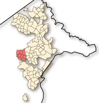
Jamestown is a town in the Mid North region of South Australia 207 kilometres (129 mi) north of Adelaide. It lies on the banks of the Belalie Creek and on the Crystal Brook-Broken Hill railway line between Gladstone and Peterborough, and ultimately on the main line linking Adelaide and Perth to Sydney. Jamestown is the council seat of its local municipality, Northern Areas Council. Jamestown is in the South Australian Legislative Assembly electoral district of Stuart and the federal Division of Grey.

Stonyfell is an eastern suburb in the foothills of Adelaide, Australia, within the council area of the City of Burnside. It has parks with walking tracks, and two creeks running through it. St Peter's Collegiate Girls' School is the only school in Stonyfell. There is a quarry and a winery, the present-day remnants of industries dating back to the early days of the colonisation of South Australia.

Port Noarlunga is a suburb in the City of Onkaparinga, South Australia. It is a small sea-side suburb, with a population of 2,918, about 30 kilometres to the south of the Adelaide city centre and was originally created as a sea port. This area is now popular as a holiday destination or for permanent residents wishing to commute to Adelaide or work locally. There is a jetty that connects to a 1.6 kilometres natural reef that is exposed at low tide.

Totness Recreation Park is a protected area in the Australian state of South Australia located within the localities of Mount Barker and Totness in the central Mount Lofty Ranges. Covering 41 hectares of land, the park is divided by the South Eastern Freeway and features a large dam. It was declared as a reserve in 1970 and re-designated as a recreation park in 1972. The park has no visitor facilities except for access tracks. It is the only park in the district, managed by the Department of Environment and Water, that is solely designated for recreation.
Booborowie is a locality in South Australia. It is located 200 km (124 mi) north of Adelaide.

Bushy Park is a native forest reserve and bird sanctuary located in the Manawatū-Whanganui region of the North Island of New Zealand. The reserve is located eight kilometres (5.0 mi) inland from Kai Iwi and has an area of approximately 99 hectares, including the Bushy Park Homestead and grounds. The forest has a diverse range of native plant species, with canopy trees including northern rātā, rimu, tawa, and pukatea. In 1962, the forest was gifted to the Royal Forest and Bird Protection Society of New Zealand by the former owner G. F. Moore, along with the homestead and its surrounds. The reserve is now managed by the Bushy Park Trust, in partnership with Forest & Bird and local iwi Ngā Rauru Kītahi. The forest reserve and homestead were renamed as Bushy Park Tarapuruhi in 2019.
Charles Rufus Goode was a pastoralist and politician in the early days of South Australia.

Anlaby or Anlaby Station is a historic heritage tourism destination located about 12 kilometres southeast of Marrabel and 14 kilometres north of Kapunda in South Australia. The property was originally established in 1839 by Frederick Dutton, and is home to the oldest Merino stud in South Australia and the second-oldest in Australia. Anlaby features a significant collection of heritage buildings on the South Australian Heritage Register, extensive gardens covering 10 acres, and continues to operate as a working farm.
Bundaleer Station was a pastoral lease that operated as a sheep station in South Australia.
William Haslam was a small businessman and politician in the Colony of South Australia.
South Australian Forestry Corporation is a business enterprise owned by the Government of South Australia which is responsible for management of publicly owned plantation forests in South Australia including the commercial production of timber and the management of forests for non-commercial purposes such as community use and as protected areas.

The District Council of Belalie was a local government area in South Australia. It was proclaimed on 11 November 1875, and initially comprised most of the cadastral Hundred of Belalie, including its central town of Jamestown. Jamestown itself had originally been planned to be named Belalie when surveyed; while the town had been renamed, the Belalie name was retained for the council. It was divided into five wards at its inception with one councillor each, the first councillors for each being appointed by proclamation. The South-East and South-West wards had been replaced by the Yarcowie and Yongala wards by 1893.
Conservation reserves of South Australia is a class of protected area used in the Australian state of South Australia where crown land under the control of the responsible minister has been dedicated for conservation purposes. This class of protected area has been in use as early as 1985. In 2016 there were 15 conservation reserves that covered an area of 194.7 square kilometres. As of March 2022 the number had increased to 16 conservation reserves covering 193.6 square kilometres or less than 1% of South Australia's land area.
