Gladstone, South Australia

Last updated

Gladstone
South Australia
Gladstone Hotel South Australia.JPG
Gladstone Hotel
Australia South Australia location map.svg
Red pog.svg
Gladstone
Location in South Australia
Coordinates 33°16′S138°21′E / 33.267°S 138.350°E / -33.267; 138.350
Population623 (UCL 2021) [1]
Postcode(s) 5473
Elevation43 m (141 ft) [2]
Location
LGA(s) Northern Areas Council
State electorate(s) Stuart
Federal division(s) Division of Grey
Localities around Gladstone:
Beetaloo Valley Laura
Caltowie West
Caltowie
Gladstone West Bundaleer
Huddleston Georgetown

Gladstone (including the former town of Booyoolie) [3] is a small rural town in the Mid North of South Australia in the approach to the lower Flinders Ranges. At the 2006 census, Gladstone had a population of 629. [4]

Contents

The town services the surrounding district with two pubs, three churches, a bank, post office and several shops and small businesses providing basic goods and services. The closest hospital is 11 km away in a neighbouring rural town, but doctors take appointments in the town's medical clinic. There is a kindergarten (approximately 12 enrollments), state primary school (63), Catholic primary school (60) and a secondary school (approximately 205 students, drawn from the wider district).

Gladstone has sporting/social clubs providing for Aussie Rules football, netball, cricket, tennis, golf, lawn bowls, swimming (at the local outdoor pool) and soccer (newly formed for school-aged children), all seasonal. Sporting competitions occur between clubs from the neighbouring towns within a radius of about 75 km.

Wheat and sheep are the main farming produce of the region, but Gladstone has the largest inland grain storage facility in the Southern Hemisphere, storing wheat, barley, durum wheat, peas, faba beans and fiesta beans.

The Anglican Diocese of Willochra is based in Gladstone, with the Registry (the Diocesan Office) housed in building in the main street. In addition the Bishop of Willochra lives in Bishop's House which is on the Main North Road.

Gladstone was the home of Trend Drinks, a local soft drink manufacturer, from its founding in 1876 until it moved to Corowa, New South Wales in 2016. [5]

History

The town of Gladstone was privately laid out by Matthew Moorhouse east of the railway line in October 1872 on Section 31, Hundred of Yangya. A government town named Booyoolie was laid out in March 1875 on the western side of the railway line in the Hundred of Booyoolie. In 1940, Booyoolie was renamed Gladstone to match the private town and railway station. The name Gladstone is derived from William Ewart Gladstone, a Prime Minister of the United Kingdom. [6]

During World War II, the RAAF No. 28 Inland Aircraft Fuel Depot was established near Gladstone. It consisted of large tanks concealed under earthen mounds. [7] The Gladstone depot was one of 31 fuel depots established across Australia in places that were remote from airfields and immune to naval attack. [8]

Heritage listings

Gladstone has a number of heritage-listed sites, including:

Railways

Gladstone Railyard March 1986 showing all three rail gauges in use on the one track bed. Gladstone Railyard March 1986 001.jpg
Gladstone Railyard March 1986 showing all three rail gauges in use on the one track bed.

Gladstone is located on the main Crystal Brook-Broken Hill railway line, with branches going north and south.

Originally, all the lines were 3 ft 6 in (1,067 mm) gauge narrow gauge railways, starting with the line from Port Pirie in 1875, extended to Petersburg (now Peterborough) in 1880 and to Cockburn (on the state border near Broken Hill) in 1888. A branch from Gladstone to Laura in 1884 was extended to Wilmington in 1915. The line from the south (extending the line that terminated at Blyth) was completed in 1894. In 1927, the line from Hamley Bridge through Blythe to Gladstone was converted to 5 ft 3 in (1,600 mm) broad gauge, making Gladstone a break-of-gauge junction. [12]

In 1970, the line from Port Pirie to Broken Hill was converted to 4 ft 8+12 in (1,435 mm) standard gauge making Gladstone into a rare three-gauge break-of-gauge junction as the Wilmington railway line to the north remained an isolated narrow gauge line. [13] In the 1980s, the broad and narrow gauge lines were closed, leaving Gladstone as a purely standard gauge station.

Related Research Articles

<span class="mw-page-title-main">Port Augusta</span> City in South Australia

Port Augusta is a small coastal city in South Australia about 310 kilometres (190 mi) by road from the state capital, Adelaide. Most of the city is on the eastern shores of Spencer Gulf, immediately south of the gulf's head, comprising the city's centre and surrounding suburbs, Stirling North, and seaside homes at Commissariat Point, Blanche Harbor and Miranda. The suburb of Port Augusta West is on the western side of the gulf on the Eyre Peninsula. Together, these localities had a population of 13,515 people in the 2021 census.

<span class="mw-page-title-main">Port Pirie</span> City in South Australia

Port Pirie is a small city on the east coast of the Spencer Gulf in South Australia, 223 km (139 mi) north of the state capital, Adelaide. Port Pirie is the largest city and the main retail centre of the Mid North region of South Australia. The city has an expansive history which dates back to 1845. Port Pirie was the first proclaimed regional city in South Australia, and is currently the second most important and second busiest port in SA.

<span class="mw-page-title-main">Tocumwal</span> Town in New South Wales, Australia

Tocumwal is a town in the southern Riverina region of New South Wales, Australia, in the Berrigan Shire local government area. The town, 270 kilometres (170 mi) north of the city of Melbourne, lies on the northern bank of the Murray River, which forms the border with Victoria.

<span class="mw-page-title-main">Crystal Brook, South Australia</span> Town in South Australia

Crystal Brook is a town in the Mid North of South Australia, 197 kilometres north of the capital, Adelaide. According to the 2021 Census, the population of the town was 1,322. Crystal Brook is in a very picturesque location, being at the start of the Flinders Ranges. The town has multiple viewing points and parks. It was named after the spring-fed creek next to which it was founded.

<span class="mw-page-title-main">Peterborough, South Australia</span> Town in South Australia

Peterborough is a town in the mid north of South Australia, in wheat country, just off the Barrier Highway. It was originally named Petersburg after the landowner, Peter Doecke, who sold land to create the town. It was one of 69 places in South Australia renamed in 1917 due to anti-German sentiments during World War I.

Australians generally assumed in the 1850s that railways would be built by the private sector. Private companies built railways in the then colonies of Victoria, opened in 1854, and New South Wales, where the company was taken over by the government before completion in 1855, due to bankruptcy. South Australia's railways were government owned from the beginning, including a horse-drawn line opened in 1854 and a steam-powered line opened in 1856. In Victoria, the private railways were soon found not to be financially viable, and existing rail networks and their expansion were taken over by the colony. Government ownership also enabled railways to be built to promote development, even if not apparently viable in strictly financial terms. The railway systems spread from the colonial capitals, except for a few lines that hauled commodities to a rural port.

<span class="mw-page-title-main">Rail transport in South Australia</span> Rail transport in South Australia

The first railway in colonial South Australia was a line from the port of Goolwa on the River Murray to an ocean harbour at Port Elliot, which first operated in December 1853, before its completion in May 1854.

<span class="mw-page-title-main">Merredin, Western Australia</span> Town in the Wheatbelt region of Western Australia

Merredin is a town in Western Australia, located in the central Wheatbelt roughly midway between Perth and Kalgoorlie, on Route 94, Great Eastern Highway. It is located on the route of the Goldfields Water Supply Scheme, and as a result is also on the Golden Pipeline Heritage Trail.

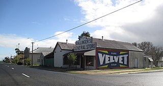
Laura is a rural town in the Mid North region of South Australia, 12 km north of Gladstone on the Horrocks Highway and 40 km east of Port Pirie. The first European to explore the district was Thomas Burr in September 1842. His promising reports soon led to occupation of the district by pastoralists, one of whom was Herbert Bristow Hughes. When the present town was surveyed he named it for his wife, Laura née White.

<span class="mw-page-title-main">Wolseley, South Australia</span> Town in South Australia

Wolseley is a small South Australian town near the Victorian border. It is five kilometres south of the Dukes Highway and 13 kilometres east of Bordertown. It was first proclaimed a town in 1884.

Booleroo Centre is a town in the southern Flinders Ranges region of South Australia. The town is located in the Mount Remarkable District Council local government area, 282 kilometres (175 mi) north of the state capital, Adelaide. At the 2006 census, Booleroo Centre had a population of 516.

<span class="mw-page-title-main">Crystal Brook–Broken Hill railway line</span>

The Crystal Brook–Broken Hill railway line is a 371 kilometre line running from Crystal Brook to Broken Hill on the Australian Rail Track Corporation network.

<span class="mw-page-title-main">Steamtown Heritage Rail Centre</span>

The Steamtown Heritage Rail Centre ("Centre") is a static railway museum based in the former railway workshops located in Peterborough, South Australia.

<span class="mw-page-title-main">Peterborough railway station, South Australia</span> Railway station in South Australia

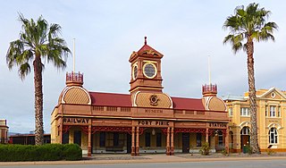
Peterborough railway station is located on the Crystal Brook-Broken Hill line in Peterborough, South Australia.

<span class="mw-page-title-main">Gladstone railway station, South Australia</span> Railway station in South Australia

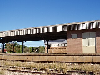
Gladstone railway station is located on the Crystal Brook-Broken Hill line in Gladstone, South Australia.

<span class="mw-page-title-main">Port Pirie railway station (Ellen Street)</span> Former railway station in South Australia, Australia

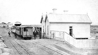
Ellen Street railway station was the second of six stations that operated successively between 1875 and the early 2010s to serve the rural maritime town of Port Pirie, 216 km (134 mi) by rail north of Adelaide, South Australia. Soon after construction of the line towards Gladstone began in 1875, an impromptu passenger service commenced. The inaugural station, Port Pirie South, was 800 metres from the centre of the town. Since two tracks had already been laid down the middle of Ellen Street to the wharves, a small corrugated iron shed was erected as a ticket and parcels office. The street-side location was unusual for the South Australian Railways. In 1902, when passenger traffic had increased greatly, a stone building was erected in a striking Victorian Pavilion style. After the tracks were removed in 1967 and the station closed, the building's design assured its retention as a museum of the National Trust of South Australia.

<span class="mw-page-title-main">Port Pirie railway station (Mary Elie Street)</span> One of Port Piries six railway stations, in operation from 1967 to 1989

Port Pirie railway station (Mary Elie Street) was the fifth of six railway stations for passengers that operated at various times from 1876 to serve the small maritime town (later city) of Port Pirie, 216 kilometres (134 miles) by rail north of Adelaide, South Australia. As with several of Port Pirie's other stations before it, the station was built to accommodate a change of track gauge on railway lines leading into the town.

Solomontown is a suburb of Port Pirie in South Australia. It was historically a separate town. It was named after Emanuel Solomon, who owned the land that the town developed on.

The Wilmington railway line was a railway line on the South Australian Railways network. It opened from Gladstone to Laura on 2 June 1884. It was extended from Laura to Booleroo Centre on 13 April 1910, and to Wilmington on 20 July 1915.

<span class="mw-page-title-main">Port Pirie South railway station</span> Railway station in South Australia

The railway station located at Port Pirie South bore the name "Port Pirie" from when it was built in 1876 until it was superseded in 1902 by a passenger station in the centre of Port Pirie. The new station was then assigned the name "Port Pirie railway station" and the original was named Port Pirie South railway station, in keeping with the naming of the adjacent Port Pirie South railway yards.

References

  1. Australian Bureau of Statistics (28 June 2022). "Gladstone (urban centre and locality)". Australian Census 2021.  OOjs UI icon edit-ltr-progressive.svg
  2. "Placename Details: Gladstone Railway Station". Property Location Browser Report. Government of South Australia. 2 December 2008. SA0026183. Retrieved 19 December 2016.
  3. "NEW TOWN NAMES APPROVED". The Advertiser (Adelaide) . South Australia. 26 July 1940. p. 10. Retrieved 5 September 2016 via National Library of Australia.
  4. Australian Bureau of Statistics (25 October 2007). "Gladstone (L) (Urban Centre/Locality)". 2006 Census QuickStats. Retrieved 23 June 2008.
  5. Mayfield, Greg (22 November 2016). "Soft-drink maker ends century tradition". The Flinders News . Retrieved 29 October 2019.
  6. "Place Names of South Australia – G". The Manning Index of South Australian History. Retrieved 19 December 2016.
  7. Peter Dunn (6 September 2006). "No 28 Inland Aircraft Fuel Depot (RAAF), Gladstone, South Australia, during WW2". Australia @ War. Retrieved 6 December 2015.
  8. Peter Weston (9 April 2013). "Northam war history rediscovered". The Avon Valley Advocate . Retrieved 6 December 2015.
  9. "Former National Australia Bank Gladstone Branch". South Australian Heritage Register. Department of Environment, Water and Natural Resources. Archived from the original on 1 March 2016. Retrieved 17 February 2016.
  10. "Bank SA (originally Savings Bank of SA) Building". South Australian Heritage Register. Department of Environment, Water and Natural Resources. Archived from the original on 1 March 2016. Retrieved 17 February 2016.
  11. "Former Gladstone Gaol". South Australian Heritage Register. Department of Environment, Water and Natural Resources. Archived from the original on 1 March 2016. Retrieved 17 February 2016.
  12. Horse and Steam, Wheat and Copper Callaghan, W.H. Australian Railway Historical Society Bulletin, January;February, 2002 pp9-27;46-63
  13. The Triple-gauge Track of Gladstone Vincent, Graham Australian Railway History, December, 2007 pp474-479