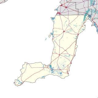
Northern Areas Council is a local government area in the Yorke and Mid North region of South Australia. The council seat and main council offices are at Jamestown, while the council also maintains district offices at Gladstone and Spalding.

Meningie is a town on the south-east side of Lake Albert in South Australia. It is on the Princes Highway near The Coorong and was surveyed in 1866. At the 2016 census, the locality of Meningie had a population of 1118 with a median age of 51 while its town centre had a population of 852.

Hynam is a town and locality in the Australian state of South Australia located in the state's south-east within the Limestone Coast region on the border with the state of Victoria about 302 kilometres south east of the state capital of Adelaide and about 11 kilometres east of the municipal seat of Naracoorte.
Nangwarry is a town and a locality in the Australian state of South Australia located about 352 kilometres (219 mi) south-east of the state capital of Adelaide and about 32 kilometres (20 mi) north-west of the regional centre of Mount Gambier.

Dowlingville is a locality in the Australian state of South Australia located on the east coast of Yorke Peninsula immediately adjoining Gulf St Vincent about 89 kilometres north-west of the state capital of Adelaide. Its boundaries were created in May 1999.

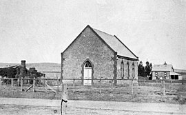
The District Council of Belalie was a local government area in South Australia. It was proclaimed on 11 November 1875, and initially comprised most of the cadastral Hundred of Belalie, including its central town of Jamestown. Jamestown itself had originally been planned to be named Belalie when surveyed; while the town had been renamed, the Belalie name was retained for the council. It was divided into five wards at its inception with one councillor each, the first councillors for each being appointed by proclamation. The South-East and South-West wards had been replaced by the Yarcowie and Yongala wards by 1893.
Sandilands is a locality in the Australian state of South Australia located on the east coast of Yorke Peninsula immediately adjoining Gulf St Vincent about 88 kilometres (55 mi) north-west of the state capital of Adelaide and about 18 kilometres (11 mi) south-east of the municipal seat in Maitland.
Mayfield is a rural locality in the Mid North region of South Australia. It is situated in the Northern Areas Council.

Cleland is a suburb in South Australia located in the Adelaide metropolitan area about 10 kilometres south-east of the Adelaide city centre. Its boundaries were created in October 2001, with additional land being added in 2010 from the adjoining suburb of Crafers. Its name is derived from the Cleland Conservation Park. The principal land use within the locality is conservation with the majority of its land area being occupied by the Cleland Conservation Park. Places within its extent include the summit of Mount Lofty. Cleland is located within the federal Division of Mayo, the state electoral district of Bragg and the local government areas of the Adelaide Hills Council and the City of Burnside.
Ballast Head is a locality in the Australian state of South Australia located on the north coast of Kangaroo Island overlooking Nepean Bay about 118 kilometres south of the state capital of Adelaide and about 19 kilometres southeast of the municipal seat of Kingscote.
Stun’Sail Boom is a locality in the Australian state of South Australia located on the south coast of Kangaroo Island overlooking the body of water known in Australia as the Southern Ocean and by international authorities as the Great Australian Bight. It is located about 186 kilometres southwest of the state capital of Adelaide and about 68 kilometres southwest of the municipal seat of Kingscote.

Western River is a locality in the Australian state of South Australia located on the north coast of Kangaroo Island overlooking Investigator Strait about 170 kilometres south-west of the state capital of Adelaide and about 64 kilometres west of the municipal seat of Kingscote.
Grace Plains is a rural locality in South Australia on the northern Adelaide Plains about 64 kilometres (40 mi) north of the state capital of Adelaide. It is divided between the Adelaide Plains Council and the Wakefield Regional Council. The formal boundaries were established in June 1997 for the long established local name with respect of the section in the District Council of Mallala ; the portion in the Wakefield council was added in January 2000. It is named after Grace Montgomery Farrell, widow of Rev C. B. Howard, the first South Australian Colonial Chaplain; she later married James Farrell, Dean of Adelaide.
Muston is a locality in the Australian state of South Australia located on Kangaroo Island overlooking the coastal lagoon known as Pelican Lagoon about 127 kilometres south-west of the state capital of Adelaide and about 21 kilometres south-east of the municipal seat of Kingscote.
Kohinoor is a locality in the Australian state of South Australia located on Kangaroo Island about 137 kilometres south-west of the state capital of Adelaide and about 20 kilometres south-east of the municipal seat of Kingscote.
Bangham is a locality in the Australian state of South Australia located in the state's south-east within the Limestone Coast region about 279 kilometres south east of the state capital of Adelaide, about 31.5 kilometres south-east of the municipal seat of Bordertown and adjoining the border with the State of Victoria.
The Hundred of Belalie is a cadastral unit of hundred located in the Mid North of South Australia in the approach to the lower Flinders Ranges. It is one of the hundreds of the County of Victoria and its main town is Jamestown, South Australia. The Hundred corresponded to the former District Council of Belalie. The rural localities of Belalie North and Belalie East derive from the hundred.
Tilley Swamp is a locality in the Australian state of South Australia located in the state's south-east about 199 kilometres (124 mi) south-east of the state capital of Adelaide and about 55 kilometres (34 mi) north of the municipal seat of Kingston SE. The 2016 Australian census, which was conducted in August 2016, reports that the area had a population of 27 people.
Mercunda is a town and a locality in the Australian state of South Australia located in the state's south-east about 134 kilometres (83 mi) east of the state capital of Adelaide, and about 52 kilometres (32 mi) north-east and about 53 kilometres (33 mi) south-west respectively of the municipal seats of Karoonda and Loxton.

Stephenston is a locality in the Australian state of South Australia located on the eastern side of the Flinders Ranges about 285 kilometres (177 mi) north of the state capital of Adelaide and about 15 kilometres (9.3 mi) east of the municipal seat of Quorn.