
Northern Areas Council is a local government area in the Yorke and Mid North region of South Australia. The council seat and main council offices are at Jamestown, while the council also maintains district offices at Gladstone and Spalding.

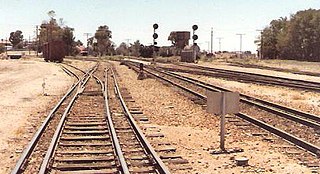
Jamestown is a town in the Mid North region of South Australia 207 kilometres (129 mi) north of Adelaide. It lies on the banks of the Belalie Creek and on the Crystal Brook-Broken Hill railway line between Gladstone and Peterborough, and ultimately on the main line linking Adelaide and Perth to Sydney. Jamestown is the council seat of its local municipality, Northern Areas Council. Jamestown is in the South Australian Legislative Assembly electoral district of Stuart and the federal Division of Grey.

Spalding is a town located north of the Clare Valley in South Australia, Australia. At the 2016 census, Spalding had a population of 215.

Kaimkillenbun is a rural town and locality in the Western Downs Region, Queensland, Australia. In the 2021 census, the locality of Kaimkillenbun had a population of 248 people.

The County of Adelaide is one of the 49 cadastral counties of South Australia and contains the city of Adelaide. It was proclaimed on 2 June 1842 by Governor Grey. It is bounded by the Gawler River and North Para River in the north, the Mount Lofty Ranges in the east, and Gulf St Vincent in the west. The south border runs from Aldinga Bay to Willunga South and Mount Magnificent.

The Broughton River is a river in the Australian state of South Australia.

J. B. Hughes was a grazier, developer and politician in the early days of the Colony of South Australia.
Edward John Pitts was an artist and pastoralist in the early days of South Australia, noted for founding The Levels as a sheep breeding establishment.

Charles Brown Fisher, generally referred to as C. B. Fisher, was an Australian pioneer pastoralist and livestock breeder.
Charles Rufus Goode was a pastoralist and politician in the early days of South Australia.
Rocky River was an electoral district of the House of Assembly in the Australian state of South Australia from March 1938 to December 1985.
Bouldercombe is a rural town and locality in the Rockhampton Region, Queensland, Australia. In the 2021 census, the locality of Bouldercombe had a population of 1,117 people.
William Haslam was a small businessman and politician in the Colony of South Australia.

The District Council of Belalie was a local government area in South Australia. It was proclaimed on 11 November 1875, and initially comprised most of the cadastral Hundred of Belalie, including its central town of Jamestown. Jamestown itself had originally been planned to be named Belalie when surveyed; while the town had been renamed, the Belalie name was retained for the council. It was divided into five wards at its inception with one councillor each, the first councillors for each being appointed by proclamation. The South-East and South-West wards had been replaced by the Yarcowie and Yongala wards by 1893.
The District Councils Act 1887 was an act of the Parliament of South Australia. It received assent on 9 December 1887, and its provisions came into effect when proclaimed by Governor William C. F. Robinson on 5 January 1888.
The District Council of Georgetown was a local government area in South Australia, centred on the town of Georgetown.
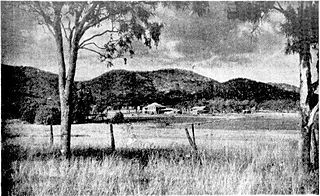
Bundaleer North is a rural locality in the Mid North region of South Australia, situated in the Northern Areas Council. Its modern boundaries were established in April 2001 for the long established local name. Bundaleer North is divided by the RM Williams Way between the Bundaleer Forest Reserve to the west and agricultural land to the east.
The County of Victoria is one of the 49 cadastral counties of South Australia. It was proclaimed by Governor Richard MacDonnell in 1857 and probably named for Queen Victoria. It covers an area of the Spencer Gulf coast and hinterland in the Mid North of the state from Port Pirie in the northwest to near Mount Bryan in the southeast, including most of the Broughton River watershed.

The Hundred of Yangya is a cadastral unit of hundred in the County of Victoria, South Australia straddling the towns and localities of Gladstone, Caltowie, West Bundaleer and Georgetown.
White Dam Conservation Park is a protected area located in the Australian state of South Australia in the localities of Lindley and Maude about 139 kilometres (86 mi) north-east of the state capital of Adelaide and about 14 kilometres (8.7 mi) north-west of the town of Morgan.
This page is based on this
Wikipedia article Text is available under the
CC BY-SA 4.0 license; additional terms may apply.
Images, videos and audio are available under their respective licenses.