List of parks and gardens in rural South Australia

Last updated

List of parks and gardens in rural South Australia refers to parks and gardens that located within the rural areas of South Australia as distinguished from those located within the Adelaide metropolitan area.

Contents

Adelaide Hills

The following parks and gardens are located within the following local government areas within the South Australian government region known as Adelaide Hills - Adelaide Hills Council and the District Council of Mount Barker. [1]

Adelaide Hills

Mount Barker

Barossa Light and Lower North

The following parks and gardens are located within the following local government areas within the South Australian government region known as the Barossa Light and Lower North - Barossa Council, Town of Gawler, Light Regional Council and Adelaide Plains Council. [2]

Barossa

Gawler

Light

Adelaide Plains

Eyre Western

The following parks and gardens are located within the following local government areas within the South Australian government region known as the Eyre Western - District Council of Ceduna, District Council of Cleve, District Council of Elliston, District Council of Franklin Harbour, District Council of Kimba, District Council of Lower Eyre Peninsula, City of Port Lincoln, District Council of Streaky Bay, District Council of Tumby Bay, City of Whyalla and Wudinna District Council. [23]

Ceduna

Cleve

Elliston

Franklin Harbour

Kimba

Lower Eyre Peninsula

Port Lincoln

Streaky Bay

Tumby Bay

Whyalla

Wudinna

Far North

The following parks and gardens are located within the following local government areas within the South Australian government region known as the Far North - District Council of Coober Pedy, Flinders Ranges Council, the City of Port Augusta and the Municipal Council of Roxby Downs. [32]

Coober Pedy

Flinders Ranges

Port Augusta

Roxby Downs

Fleurieu and Kangaroo Island

The following parks and gardens are located within the following local government areas within the South Australian government region known as the Fleurieu and Kangaroo Island - Alexandrina Council, Kangaroo Island Council, the City of Victor Harbor and the District Council of Yankalilla. [37]

Alexandrina

Kangaroo Island

Victor Harbor

Yankalilla

Limestone Coast

The following parks and gardens are located within the following local government areas within the South Australian government region known as the Limestone Coast - District Council of Grant, Kingston District Council, The City of Mount Gambier, Naracoorte Lucindale Council, District Council of Robe, Tatiara District Council and Wattle Range Council. [42]

Grant

Kingston

Mount Gambier

Naracoorte Lucindale

Robe

Tatiara

Wattle Range

Murray Mallee

The following parks and gardens are located within the following local government areas within the South Australian government region known as the Murray Mallee - Berri Barmera Council, District Council of Karoonda East Murray, District Council of Loxton Waikerie, Mid Murray Council, Rural City of Murray Bridge, Renmark Paringa Council, Southern Mallee District Council and Coorong District Council. [53]

Berri Barmera

Karoonda East Murray

Loxton Waikerie

Mid Murray

Murray Bridge

Renmark Paringa

Southern Mallee

Coorong

Yorke Mid North

The following parks and gardens are located within the following local government areas within the South Australian government region known as the Yorke Mid North - District Council of Barunga West, District Council of Clare and Gilbert Valleys, District Council of the Copper Coast, Regional Council of Goyder, District Council of Mount Remarkable, Northern Areas Council, District Council of Orroroo Carrieton, District Council of Peterborough, Port Pirie Regional Council, Wakefield Regional Council and Yorke Peninsula Council. [60]

Barunga West

Clare and Gilbert Valleys

Copper Coast

Goyder

Mount Remarkable

Northern Areas

Orroroo Carrieton

Peterborough

Port Pirie

Wakefield

Yorke Peninsula

See also

Related Research Articles

<span class="mw-page-title-main">Spencer Gulf</span> Large inlet in South Australia

The Spencer Gulf is the westernmost and larger of two large inlets on the southern coast of Australia, in the state of South Australia, facing the Great Australian Bight. It spans from the Cape Catastrophe and Eyre Peninsula in the west to Cape Spencer and Yorke Peninsula in the east.

<span class="mw-page-title-main">St Kilda West, Victoria</span> Suburb of Melbourne, Victoria, Australia

St Kilda West is an inner suburb in Melbourne, Victoria, Australia, 5 km south of Melbourne's Central Business District, located within the City of Port Phillip local government area. St Kilda West recorded a population of 2,951 at the 2021 census.

<span class="mw-page-title-main">Botany, New South Wales</span> Suburb of Sydney, New South Wales, Australia

Botany is a suburb in the Inner Southern Suburbs of Sydney, in the state of New South Wales, Australia. Botany is located 11 kilometres south of the Sydney central business district and is part of the Bayside Council.

<span class="mw-page-title-main">Adelaide railway station</span> Railway station in Adelaide, South Australia

Adelaide railway station is the central terminus of the Adelaide Metro railway system. All lines approach the station from the west, and it is a terminal station with no through lines, with most of the traffic on the metropolitan network either departing or terminating here. It has nine below-ground platforms, all using broad gauge track. The station is located on the north side of North Terrace, west of Parliament House.

The Division of Barker is an Australian electoral division in the south-east of South Australia. The division was established on 2 October 1903, when South Australia's original single multi-member division was split into seven single-member divisions. It is named for Collet Barker, an early explorer of the region at the mouth of the Murray River. The 63,886 km² seat currently stretches from Morgan in the north to Port MacDonnell in the south, taking in the Murray Mallee, the Riverland, the Murraylands and most of the Barossa Valley, and includes the towns of Barmera, Berri, Bordertown, Coonawarra, Keith, Kingston SE, Loxton, Lucindale, Mannum, Millicent, Mount Gambier, Murray Bridge, Naracoorte, Penola, Renmark, Robe, Tailem Bend, Waikerie, and parts of Nuriootpa and Tanunda.

<span class="mw-page-title-main">Wallaroo, South Australia</span> Town in South Australia

Wallaroo is a port town on the western side of Yorke Peninsula in South Australia, 160 kilometres (100 mi) northwest of Adelaide. It is one of the three Copper Triangle towns famed for their historic shared copper mining industry, and known together as "Little Cornwall", the other two being Kadina, about 8 kilometres (5 mi) to the east, and Moonta, about 18 kilometres (11 mi) south. In 2016, Wallaroo had a population of 3,988 according to the census held.

<span class="mw-page-title-main">Rail transport in South Australia</span> Rail transport in South Australia

The first railway in colonial South Australia was a line from the port of Goolwa on the River Murray to an ocean harbour at Port Elliot, which first operated in December 1853, before its completion in May 1854.

<span class="mw-page-title-main">Monash, South Australia</span> Town in South Australia

Monash is a town in the Riverland area of South Australia. It is on the Sturt Highway between Barmera and Renmark.

<span class="mw-page-title-main">Riverland</span> Region in South Australia

The Riverland is a region of South Australia. It covers an area of 9,386 square kilometres (3,624 sq mi) along the River Murray from where it flows into South Australia from New South Wales and Victoria downstream to Blanchetown. The major town centres are Renmark, Berri, Loxton, Waikerie, Barmera and Monash, and many minor townships. The population is approximately 35,000 people.

<span class="mw-page-title-main">Loxton, South Australia</span> Town in South Australia

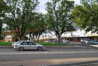
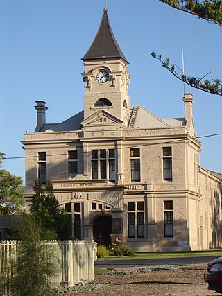
Loxton is a town on the south bank of the River Murray in the Riverland region of South Australia. It is located on the lands of the Erawirung people who occupied the area before the arrival of Europeans.

<span class="mw-page-title-main">Port Neill, South Australia</span> Town in South Australia

Port Neill is a small coastal town on the eastern side of the Eyre Peninsula, in South Australia about 3 km off the Lincoln Highway between the major towns of Whyalla and Port Lincoln. It is 576 km by road from Adelaide.

Victoria and Albert was an electoral district in the South Australian House of Assembly from 1902 to 1915. The seat elected candidates of both major parties at various times. It merged the seats of Victoria and Albert, which were both recreated on its abolition.

The Loxton News was a weekly newspaper published in Loxton, South Australia, and published continuously between April 1960 and April 2020.

References

  1. "Adelaide Hills SA Government region" (PDF). The Government of South Australia. Retrieved 6 July 2015.
  2. "Barossa Light and Lower North SA Government region" (PDF). The Government of South Australia. Retrieved 6 July 2015.
  3. 1 2 3 "Angas Recreation Park". Barossa Council. Retrieved 6 July 2015.
  4. "Barossa Bushgardens". Australian National Botanic Gardens. Retrieved 11 July 2015.
  5. "Curdnatta Park". Barossa Council. Retrieved 11 July 2015.
  6. "Moculta Recreation Park". Barossa Council. Retrieved 11 July 2015.
  7. "Murray Recreation Park". Barossa Council. Retrieved 11 July 2015.
  8. "Stockwell Recreation Park". Barossa Council. Retrieved 11 July 2015.
  9. "Talunga Recreation Park". Barossa Council. Retrieved 11 July 2015.
  10. "Talunga Recreation Park". Barossa Council. Retrieved 11 July 2015.
  11. "Williamstown Queen Victoria Jubilee Park". Barossa Council. Retrieved 11 July 2015.
  12. 1 2 3 4 5 6 7 "Apex Park". Town of Gawler. Retrieved 11 July 2015.
  13. "Clonlea Park". Town of Gawler. Retrieved 11 July 2015.
  14. "Pioneer Park". Town of Gawler. Retrieved 11 July 2015.
  15. "Reserves". Light Regional Council. Retrieved 15 July 2015.
  16. "Pengilly Scrub (Mudla Wirra Reserve)". Light Regional Council. Retrieved 15 July 2015.
  17. "The Pines Conservation Reserve". Light Regional Council. Retrieved 15 July 2015.
  18. "Dutton Park, Kapunda". Light Regional Council. Retrieved 15 July 2015.
  19. "Freeling Community Recreation Park". Light Regional Council. Retrieved 15 July 2015.
  20. "Greenock Centenary Park". Light Regional Council. Retrieved 15 July 2015.
  21. "Wasleys Recreation Park". Light Regional Council. Retrieved 15 July 2015.
  22. 1 2 3 4 5 6 7 8 9 10 11 12 13 14 15 16 17 18 19 20 21 22 23 24 25 26 27 28 29 30 31 32 33 "Parks, Gardens and reserves". District Council of Mallala. Retrieved 6 July 2015.
  23. "Eyre Western SA Government region" (PDF). The Government of South Australia. Retrieved 6 July 2015.
  24. 1 2 3 4 "Parks, Gardens and Ovals". District Council of Ceduna. Retrieved 6 July 2015.
  25. 1 2 3 4 5 "Parks & Playgrounds". District Council of Cleve. Retrieved 6 July 2015.
  26. 1 2 "Parks and Gardens". District Council of Kimba. Retrieved 6 July 2015.
  27. "Parks & Playgrounds". District Council of Lower Eyre Peninsula. Retrieved 6 July 2015.
  28. "Cummins Railway Triangle". District Council of Lower Eyre Peninsula. Retrieved 11 July 2015.
  29. 1 2 3 4 5 6 7 8 9 10 11 "Parks & Gardens". District Council of Streaky Bay. Retrieved 6 July 2015.
  30. 1 2 3 4 5 6 7 8 9 10 11 12 13 14 15 16 17 18 19 20 21 "Parks and Gardens". District Council of Tumby Bay. Retrieved 6 July 2015.
  31. 1 2 3 4 5 6 7 8 "Parks, playgrounds & reserves". Wudinna District Council. Retrieved 6 July 2015.
  32. "Far North SA Government region" (PDF). The Government of South Australia. Retrieved 5 July 2015.
  33. 1 2 3 4 5 "Parks Gardens and Ovals". Flinders Ranges Council. Retrieved 6 July 2015.
  34. 1 2 "Parks Gardens and Ovals". Flinders Ranges Council. Retrieved 6 July 2015.
  35. 1 2 3 4 5 6 7 8 9 10 11 12 13 14 15 16 "Parks and Gardens". City of Port Augusta. Retrieved 6 July 2015.
  36. "Roxby Leisure". Municipal Council of Roxby Downs. Retrieved 6 July 2015.
  37. "Fleurieu and Kangaroo Island SA Government region" (PDF). The Government of South Australia. Retrieved 5 July 2015.
  38. 1 2 3 4 5 6 7 8 9 10 11 12 "Recreation". Alexandrina Council. Retrieved 5 July 2015.
  39. 1 2 3 4 5 6 7 8 9 10 11 12 13 14 15 16 17 18 19 20 "Parks and Reserves". Kangaroo Island Council. Retrieved 5 July 2015.
  40. 1 2 3 4 5 6 7 8 9 10 11 12 13 14 15 16 17 18 19 20 21 22 23 24 "Yankalilla Parks, Gardens and Ovals". District Council of Yankalilla. Retrieved 5 July 2015.
  41. "Ingalalla Waterfalls". District Council of Yankalilla. Retrieved 15 July 2015.
  42. "Limestone Coast SA Government region" (PDF). The Government of South Australia. Retrieved 5 July 2015.
  43. 1 2 3 4 5 6 7 8 9 10 11 12 13 14 "Playgrounds". District Council of Grant. Retrieved 5 July 2015.
  44. "Risk Management Plan, Little Blue Lake" (PDF). District Council of Grant. Retrieved 26 February 2014.
  45. 1 2 3 4 5 6 7 "Parks & Gardens". District Council of Kingston. Retrieved 5 July 2015.
  46. 1 2 3 "Parks & Playgrounds". District Council of Robe. Retrieved 5 July 2015.
  47. 1 2 3 4 5 6 7 8 9 10 11 12 13 14 15 16 17 18 19 20 21 22 23 "Parks & Gardens". Tatiara District Council. Retrieved 5 July 2015.
  48. 1 2 3 4 5 6 "Parks - Beachport". Wattle Range Council. Retrieved 5 July 2015.
  49. "Parks - Coonawarra". Wattle Range Council. Retrieved 5 July 2015.
  50. 1 2 3 4 "Parks - Kalangadoo". Wattle Range Council. Retrieved 5 July 2015.
  51. 1 2 3 4 5 6 7 8 9 10 11 12 13 14 15 16 17 18 19 20 21 22 23 24 25 "Parks - Millicent". Wattle Range Council. Retrieved 5 July 2015.
  52. 1 2 3 4 5 "Parks - Penola". Wattle Range Council. Retrieved 5 July 2015.
  53. "Murray Mallee SA Government region" (PDF). The Government of South Australia. Retrieved 5 July 2015.
  54. 1 2 3 4 5 6 7 8 9 10 11 12 13 14 15 16 17 18 19 20 21 22 23 24 25 26 27 28 29 30 31 32 "Parks gardens and ovals". Berri Barmera Council. Retrieved 5 July 2015.
  55. 1 2 3 "Parks - Playgrounds". District Council of Karoonda East Murray. Retrieved 5 July 2015.
  56. 1 2 3 4 5 6 7 8 9 10 11 12 13 14 15 16 17 18 19 20 21 22 23 24 25 26 27 28 29 30 31 32 33 34 35 36 37 38 39 40 41 42 43 44 "Parks and Reserves List". District Council of Loxton and Waikerie. Retrieved 5 July 2015.
  57. 1 2 3 4 5 6 7 8 9 10 11 12 13 14 15 16 17 18 19 20 "Parks, Gardens & Reserves". Mid Murray Council. Retrieved 5 July 2015.
  58. 1 2 3 4 5 "Parks & Gardens". Southern Mallee District Council. Retrieved 5 July 2015.
  59. 1 2 3 4 5 6 7 8 9 10 11 12 13 14 15 16 17 18 19 20 21 "Parks & Gardens". The Coorong District Council. Retrieved 5 July 2015.
  60. "Yorke Mid North SA Government region" (PDF). The Government of South Australia. Retrieved 5 July 2015.
  61. 1 2 3 "Parks Gardens and Ovals". District Council of Barunga West. Retrieved 6 July 2015.
  62. 1 2 3 4 5 6 7 8 9 10 11 12 13 14 15 16 17 18 19 20 21 22 23 24 25 26 27 "Parks Gardens and Ovals". District Council of Clare & Gilbert Valleys. Retrieved 18 December 2022.
  63. 1 2 3 4 5 "Kadina Parks and Reserves". District Council of the Copper Coast. Retrieved 7 July 2015.
  64. 1 2 3 "Moonta Parks & Reserves". District Council of the Copper Coast. Retrieved 7 July 2015.
  65. 1 2 "Moonta Bay Parks & Reserves". District Council of the Copper Coast. Retrieved 7 July 2015.
  66. 1 2 3 "North Beach Parks & Reserves". District Council of the Copper Coast. Retrieved 7 July 2015.
  67. 1 2 3 4 "Port Hughes Parks & Reserves". District Council of the Copper Coast. Retrieved 7 July 2015.
  68. 1 2 3 4 5 6 7 8 9 10 11 12 13 14 15 "Wallaroo Parks & Reserves". District Council of the Copper Coast. Retrieved 7 July 2015.
  69. 1 2 3 4 5 6 7 8 9 10 11 12 13 14 15 "Parks, Gardens & Ovals". Regional Council of Goyder. Retrieved 7 July 2015.
  70. 1 2 3 4 5 6 7 8 9 10 11 12 "Parks, Ovals and Playgrounds". Northern Areas Council. Retrieved 7 July 2015.
  71. 1 2 3 4 "Parks". District Council of Peterborough. Retrieved 7 July 2015.
  72. "Skate Park". District Council of Peterborough. Retrieved 7 July 2015.
  73. 1 2 3 4 5 6 7 8 9 10 11 12 13 14 15 16 17 18 19 20 21 22 23 24 25 26 27 "All Parks - Maps and Facilities". Port Pirie Regional Council. Retrieved 7 July 2015.