Waterfall Gully is an eastern suburb of the South Australian capital city of Adelaide. It is located in the foothills of the Mount Lofty Ranges around 5 km (3.1 mi) east-south-east of the Adelaide city centre. For the most part, the suburb encompasses one long gully with First Creek at its centre and Waterfall Gully Road running adjacent to the creek. At the southern end of the gully is First Falls, the waterfall for which the suburb was named. Part of the City of Burnside, Waterfall Gully is bounded to the north by the suburb of Burnside, from the north-east to south-east by Cleland National Park, to the south by Crafers West, and to the west by Leawood Gardens and Mount Osmond.

Mount Lofty is the highest point in the southern Mount Lofty Ranges. It is located about 15 km (9.3 mi) east of the Adelaide city centre, within the Cleland National Park in the Adelaide Hills area of South Australia.

The Adelaide Botanic Garden is a 51-hectare (130-acre) public garden at the north-east corner of the Adelaide city centre, in the Adelaide Park Lands. It encompasses a fenced garden on North Terrace and behind it the Botanic Park. Work was begun on the site in 1855, with its official opening to the public on 4 October 1857.

Stirling is a town in the Adelaide Hills, South Australia, approximately 15 km from the Adelaide city centre. It is administered by the Adelaide Hills Council. Neighbouring townships are Crafers and Aldgate. Other nearby towns are Heathfield and Bridgewater. Of those five, Stirling has by far the largest commercial strip, with the greatest number and widest variety of shops, and the only banks. Stirling East, a similar sized area towards Aldgate, is home to several schools.
Greenhill is a suburb of Adelaide located about 9.3 kilometres (5.8 mi) east of the city centre in the foothills of the Adelaide Hills. Its boundaries were created in October 2001 in respect of the "long established name" with some land being moved into the adjoining suburb of Waterfall Gully in July 2002. The suburb includes Greenhill Recreation Park and the western slopes of Mount Lofty. Greenhill Creek flows through Waterfall Gully and feeds into First Creek.

Spring Gully Conservation Park, formerly the Spring Gully National Park), is a protected area located in the Australian state of South Australia in the localities of Sevenhills and Spring Gully about 6 kilometres (3.7 mi) south of the town centre in Clare.

Totness Recreation Park is a protected area in the Australian state of South Australia located within the localities of Mount Barker and Totness in the central Mount Lofty Ranges. Covering 41 hectares of land, the park is divided by the South Eastern Freeway and features a large dam. It was declared as a reserve in 1970 and re-designated as a recreation park in 1972. The park has no visitor facilities except for access tracks. It is the only park in the district, managed by the Department of Environment and Water, that is solely designated for recreation.
The Wittunga Botanic Garden is one of three Botanic Gardens in Adelaide, South Australia administered by the Botanic Gardens of South Australia, a State Government statutory authority; the other two are the Adelaide Botanic Garden located in the inner city's parklands, and the Mount Lofty Botanic Garden. The Wittunga garden is located on Shepherds Hill Road, Blackwood, on the western scarp of the Adelaide Hills.

Black Hill Conservation Park, formerly the Black Hill National Park, is a protected area in the Australian state of South Australia located approximately 10 kilometres (6.2 mi) northeast of the state capital of Adelaide. The conservation park is in a rugged bush environment, with a prominent peak, bounded by steep ridges on the southern slopes.

Mount Magnificent Conservation Park is a protected area in the Australian state of South Australia located in the Mount Lofty Ranges about 58 kilometres south of the state capital of Adelaide. It is located within the gazetted locality of Mount Magnificent.
Finniss Conservation Park is a protected area in the Australian state of South Australia located in the Mount Lofty Ranges about 43 kilometres south of the state capital of Adelaide and about 7 kilometres west of Ashbourne. It is located within the gazetted locality of Mount Magnificent.

Horsnell Gully Conservation Park is a protected area in the Australian state of South Australia in the locality of Horsnell Gully located about 9 kilometres (5.6 mi) east of the state capital of Adelaide and about 2.3 kilometres (1.4 mi) southwest of Norton Summit.

Anstey Hill Recreation Park is a 362-hectare (890-acre) protected area established in 1989 and located approximately 19 kilometres (12 mi) northeast of Adelaide, South Australia. The park is a significant reserve of bushland in the foothills of the Mount Lofty Ranges and is home to rare or vulnerable native plants and animals, and problematic invasive species. It is managed by the City of Tea Tree Gully, the Department of Environment, Water and Natural Resources and a volunteer group—The Friends of Anstey Hill. The park is designed for recreational walking and has no visitor facilities. It is managed in association with the regional planning initiative known as of Yurrebilla, the Greater Mount Lofty Parklands.
Cromer Conservation Park is a protected area located in the Australian state of South Australia in the locality of Cromer in the Adelaide Hills state government region about 38 kilometres (24 mi) north-east of the state capital of Adelaide and about 4 kilometres (2.5 mi) north of the town centre in Birdwood.
Charleston Conservation Park is a protected area located in the Australian state of South Australia in the locality of Charleston in the Adelaide Hills state government region about 32 kilometres (20 mi) east of the state capital of Adelaide and about 7 kilometres (4.3 mi) north of the town centre in Lobethal.
Eurilla Conservation Park was a protected area located in the Australian state of South Australia in the suburb of Crafers in the Adelaide Hills state government region about 11 kilometres (6.8 mi) south-east of the state capital of Adelaide and about 2.4 kilometres (1.5 mi) north of the town centre in Stirling. It was merged with the adjoining Cleland Conservation Park to become a national park called Cleland National Park on 26 November 2021.
Jip Jip Conservation Park is a protected area in the Australian state of South Australia located in the state’s south-east in the gazetted locality of Marcollat about 223 kilometres (139 mi) south-east of the state capital of Adelaide and about 50 kilometres (31 mi) north-east of the municipal seat of Kingston SE.
Gum Tree Gully Conservation Park is a protected area in the Australian state of South Australia located in the locality of Hindmarsh Tiers about 55 kilometres (34 mi) south of the state capital of Adelaide and about 6 kilometres (3.7 mi) south-east of Myponga.

The Santos Museum of Economic Botany, located in the Adelaide Botanic Gardens, displays a permanent collection exhibiting the practical, medicinal and economic use of plant materials.
Mount Boothby Conservation Park, formerly the Mount Boothby National Park, is a protected area in the Australian state of South Australia located in the locality of Field about 147 kilometres (91 mi) south-east of the state capital of Adelaide and about 14 kilometres (8.7 mi) west of the Culburra town centre on the Dukes Highway.
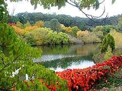
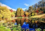 Stunning Autumn Colours in the Adelaide Hills
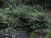 Mossy rock pool, Spring Gully
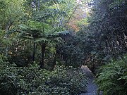 Tree ferns in Fern Gully
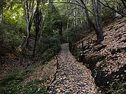 Fern Gully path, with fallen birch leaves
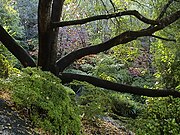 Upper section of Fern Gully path
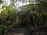 Tree ferns in Fern Gully