
Protected areas of Australia include Commonwealth and off-shore protected areas managed by the Australian government, as well as protected areas within each of the six states of Australia and two self-governing territories, the Australian Capital Territory and the Northern Territory, which are managed by the eight state and territory governments.

Bald Rock National Park is a national park in northern New South Wales, Australia, just north of Tenterfield on the Queensland border. The border passes over the rock on the Western side. On the other side of the border national park continues as the Girraween National Park.
Gawler Ranges National Park is a 1,633 km2 (631 sq mi) protected area lying 350 km (217 mi) north-west of Adelaide in the northern Eyre Peninsula of South Australia. It is known for its spectacular rock formations.

Girraween National Park is an area of the Granite Belt in the Darling Downs region of Queensland, Australia reserved as a national park. Girraween is known for its spectacular flowers, dramatic landscapes and unique wildlife. Bushwalking and rock climbing are the most popular activities in the park.
A monolith is a geological feature consisting of a single massive stone or rock, such as some mountains. For instance, Savandurga mountain is a monolith mountain in India. Erosion usually exposes the geological formations, which are often made of very hard and solid igneous or metamorphic rock. Some monoliths are volcanic plugs, solidified lava filling the vent of an extinct volcano.

The Budawang Range, commonly called The Budawangs, a rugged mountain range within the Budawang National Park and the Morton National Park, are part of a spur off the Great Dividing Range and are located in the South Coast region of New South Wales, Australia.

Kyneton is a town in the Macedon Ranges region of West Central Victoria, Australia. The Calder Freeway bypasses Kyneton to the north and east. Kyneton is on Dja Dja Wurrung, Taungurung and Wurundjeri Woi Wurrung country.

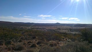
Wudinna is a town in South Australia. The area was first settled by Europeans in 1861 when Robert George Standley lodged a claim for 10 square miles (26 km2) of land surrounding Weedna Hill. It was proclaimed a town in 1916. It is on the Eyre Highway across the top of Eyre Peninsula. It is the seat of the Wudinna District Council.
Port MacDonnell, originally known as Ngaranga is the southernmost town in South Australia. The small port located in the Limestone Coast region about 477 kilometres (296 mi) southeast of Adelaide and 28 kilometres (17 mi) south of Mount Gambier in the District Council of Grant local government area. The 2016 Australian census which was conducted in August 2016 reports that the locality of Port MacDonnell had a population of 847 of which 671 lived in its town centre. Once a busy shipping port, the town now relies heavily on its fishing and summer tourism industries, particularly rock lobster harvest industry, proclaiming itself "Australia's Southern Rock Lobster Capital".
The Mid West Football League was an Australian rules football competition based in the Eyre Peninsula region of South Australia, Australia. It was wound up prior to the 2021 season after Wudinna and Central Eyre merged and transferred to the Eastern Eyre Football League.

Wudinna District Council is a rural local government area on central Eyre Peninsula, South Australia. Its seat is Wudinna, on the Eyre Highway, 580 kilometres (360 mi) west of Adelaide. The district's economy is largely driven by agriculture, mainly cereal crops, with beef and sheep commonly farmed as well.

The Glass House Mountains are a cluster of thirteen hills that rise abruptly from the coastal plain on the Sunshine Coast, Queensland, Australia. The highest hill is Mount Beerwah at 556 metres above sea level, but the most identifiable of all the hills is Mount Tibrogargan which from certain angles bears a resemblance to a face staring east towards the ocean. The Glass House Mountains are located near Beerburrum State Forest and Steve Irwin Way. From Brisbane, the mountains can be reached by following the Bruce Highway north and taking the Glass House Mountains tourist drive turn-off onto Steve Irwin Way. The trip is about one hour from Brisbane. The Volcanic peaks of the Glass House Mountains rise dramatically from the surrounding Sunshine Coast landscape. They were formed by intrusive plugs, remnants of volcanic activity that occurred 26–27 million years ago. Molten rock filled small vents or intruded as bodies beneath the surface and solidified into land rocks. Millions of years of erosion have removed the surrounding exteriors of volcanic cores and softer sandstone rock.

The Eyre Peninsula Railway is a 1,067 mm gauge railway on the Eyre Peninsula of South Australia. Radiating out from the ports at Port Lincoln and Thevenard, it is isolated from the rest of the South Australian railway network. Peaking at 777 kilometres in 1950, today only a 60 kilometre section remains open. It is currently operated by Aurizon.

The County of Robinson is one of the 49 counties of South Australia. It was proclaimed in 1883 by Governor William Robinson who named it after himself. It lies on the north west coast of Eyre Peninsula stretching from Streaky Bay inland to include the Gawler Ranges Conservation Park at the southern cusp of the Gawler Ranges.

Pancha Rathas is a monument complex at Mahabalipuram, on the Coromandel Coast of the Bay of Bengal, in the Kancheepuram district of the state of Tamil Nadu, India. Pancha Rathas is an example of monolithic Indian rock-cut architecture. The complex was initially thought to have carved during the reign of King Narasimhavarman I However, historians such as Nagaswamy attributed all of monuments in Mahabalipuram to Narasimhavarman II with the discovery of new inscriptions. The complex is under the auspices of the Archaeological Survey of India (ASI) and is part of the UNESCO World Heritage site inscribed by UNESCO as Group of Monuments at Mahabalipuram.

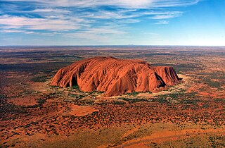
Kokerbin Rock, also known as Kokerbin Hill, is a granite rock formation located within Kokerbin Nature Reserve in the Wheatbelt region of Western Australia. The area has special significance for the Nyoongar. There are claims that Kokerbin Rock is the third largest monolith in Australia, with Mount Wudinna in South Australia being the second largest and Uluru in the Northern Territory being the largest.

Mount Augustus is located roughly 1,000 km north of Perth, in the Mount Augustus National Park in Western Australia. The name is also given to the neighbouring pastoral lease, Mount Augustus Station. The local Wadjari people call it Burringurrah, after a Dreamtime figure, a young boy who was speared and turned into a rock. It has been a sacred site for thousands of years.
Kirkala Station is a pastoral lease that operates as a sheep station in South Australia.
Whyalla Norrie is a suburb of Whyalla on the Eyre Peninsula of South Australia. It was gazetted as a distinct suburb in 1967, and had its boundaries altered in 1975 and 2000. It is bounded by Iron Knob Road, Norrie Avenue, Broadbent Terrace and MacDouall Stuart Avenue. It is part of the City of Whyalla.

County of Le Hunte is a cadastral unit located in the Australian state of South Australia that covers land located in the centre of Eyre Peninsula. It was proclaimed in 1908 and named after George Le Hunte who was the Governor of South Australia from July 1903 to February 1909.