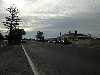
Dublin is a small town on the Adelaide Plains in South Australia, 61 kilometres (38 mi) north of the state capital, Adelaide. Situated on Highway 1, the town is surrounded by farmland and rural industry. Along with nearby Windsor the area is home to a growing commuter population. At the 2006 census, Dublin had a population of 241.

Port Wakefield is a town at the mouth of the River Wakefield, at the head of the Gulf St Vincent in South Australia. It was the first government town to be established north of the state capital, Adelaide. Port Wakefield is situated 98.7 kilometres from the Adelaide city centre on the Port Wakefield Highway section of the A1 National Highway.

Two Wells is a town approximately 40 kilometres north of the Adelaide city centre in South Australia adjacent to Port Wakefield Road and passed by the Adelaide-Port Augusta railway line. The first settlers in the area used two aboriginal wells in the area as a freshwater source. At the 2016 census, Two Wells had a population of 1926.

Kadina is a town on the Yorke Peninsula of the Australian state of South Australia, approximately 144 kilometres north-northwest of the state capital of Adelaide. The largest town of the Peninsula, Kadina is one of the three Copper Triangle towns famous for their shared copper mining history. The three towns are known as "Little Cornwall" for the significant number of immigrants from Cornwall who worked at the mines in the late 19th century.

Wool Bay is a locality and a former government town in the Australian state of South Australia on the east coast of southern Yorke Peninsula. It is located between Stansbury and Coobowie on Yorke Peninsula, approximately 220 kilometres from Adelaide by road, but only just over 60 km due west across Gulf St Vincent.

Mallala is a township and locality in the Australian state of South Australia 62 kilometres (39 mi) by road north of the state capital of Adelaide. The name is thought to be derived from the Kaurna word madlala or madlola, meaning "place of the ground frog". In the 2021 census, the wider Mallala locality had a population of 1042, of whom 887 lived in the township.

The Adelaide Plains Council is a local government area in South Australia. It consists of a largely rural region along the Gulf St Vincent, covering a total area of approximately 926 km2. The council seat lies at Mallala, but it also maintains a service centre at Two Wells.
Middle Beach is a small town in South Australia located about 40 kilometres northwest of the Adelaide city centre in the State of Southern Australia. It is located in the Adelaide Plains Council.

Clinton is a locality in the Australian state of South Australia located on the east coast of Yorke Peninsula overlooking the north west head of Gulf St Vincent about 101 kilometres (63 mi) west of the state capital of Adelaide and about 36 kilometres (22 mi) north-east of the municipal seat of Maitland.
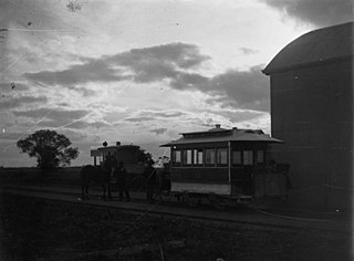
Mundoora is a settlement in South Australia, 16 km inland from Port Broughton, to which it was connected by the horse-drawn Port Broughton tramway around 1876. Its tram, dubbed "The Pie Cart", which was described as a "kind of second-hand coffin drawn by one horse" and still in operation in 1923 was later relegated to the Railways Museum and the line dismantled.
Port Gawler is a locality and former port on Gulf St Vincent on the central Adelaide Plains in South Australia. Port Gawler is located 43 kilometres (27 mi) north west of Adelaide in the Adelaide Plains Council local government area at the mouth of the Gawler River.
Windsor is a locality in South Australia. It is on the northern Adelaide Plains adjacent to Port Wakefield Road, 34 km southeast of Port Wakefield. The township is largely bypassed by Port Wakefield Road.
Webb Beach is a locality in the Australian state of South Australia located on the eastern coastline of Gulf St Vincent about 62 kilometres north-northwest of the state capital of Adelaide. The 2016 Australian census which was conducted in August 2016 reports that it had a population of 47 people. Webb Beach is located within the federal Division of Grey, the state electoral district of Narungga, and the local government area of the Adelaide Plains Council.

Wild Horse Plains is a locality in South Australia on the eastern coastline of Gulf St Vincent about 69 kilometres north-northwest of the Adelaide city centre. Its name is attributed to Thomas Day, who found wild horses grazing within the locality around 1870. Its boundaries, created in June 1997, include the town of Wild Horse Plains, established in 1881 on Port Wakefield Road, and the former Government Town of Lorne. Port Lorne Road marks most of the northern boundary of Wild Horse Plains and is the access road to the former township of Lorne.

The Hundred of Port Gawler is a cadastral unit of hundred located on the central Adelaide Plains in South Australia and bounded on the south by the Gawler River. It is centred on the town of Two Wells with the locality of Port Gawler at the south western corner of its boundary. It is one of the eight hundreds of the County of Gawler. It was named in 1851 by Governor Henry Young either directly or indirectly after the former Governor George Gawler.
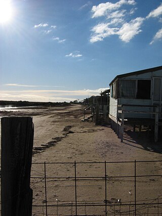
Thompson Beach is a locality in the Australian state of South Australia located on the eastern coastline of Gulf St Vincent about 56 kilometres north of the Adelaide city centre. Thompson Beach started as a sub-division in 1980 with boundaries being created in June 1997. Land use with the locality is principally residential with built development being of a ‘low density’. Thompson Beach is located within the federal Division of Grey, the state electoral district of Narungga, and the local government area of the Adelaide Plains Council.

Calomba is a rural locality in South Australia, situated in the Adelaide Plains Council. The formal boundaries were established in 1997 for the long established local name. The place name is supposed to have come from Trigonella suavissima, a native plant also known as calomba.

Long Plains is a rural locality and small township on the northern Adelaide Plains in South Australia, 73 km north of Adelaide. It is divided between the Wakefield Regional Council and the Adelaide Plains Council. The formal boundaries were established in 1997 for the long established local name with respect of the section in the Adelaide Plains Council; the portion in the Wakefield Council was added in January 2000.
Grace Plains is a rural locality in South Australia on the northern Adelaide Plains about 64 kilometres (40 mi) north of the state capital of Adelaide. It is divided between the Adelaide Plains Council and the Wakefield Regional Council. The formal boundaries were established in June 1997 for the long established local name with respect of the section in the District Council of Mallala ; the portion in the Wakefield council was added in January 2000. It is named after Grace Montgomery Farrell, widow of Rev C. B. Howard, the first South Australian Colonial Chaplain; she later married James Farrell, Dean of Adelaide.

The District Council of Dublin was a local government area in South Australia from 1873 to 1935, seated at Dublin.


