Middle Beach, South Australia

Last updated

Middle Beach
South Australia
MiddleBeach.jpg
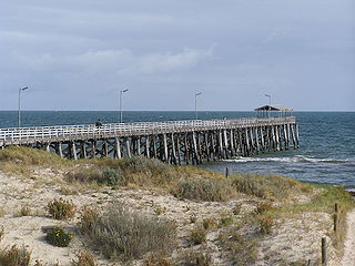
Looking north along the beachfront shacks
Australia South Australia location map.svg
Red pog.svg
Middle Beach
Coordinates 34°36′27″S138°24′38″E / 34.607565°S 138.410588°E / -34.607565; 138.410588 [1]
Population94 (SAL 2021) [2]
Established5 June 1997 (locality) [3]
Postcode(s) 5501
Time zone ACST (UTC+9:30)
 • Summer (DST) ACST (UTC+10:30)
Location40 km (25 mi) from Adelaide
LGA(s) Adelaide Plains Council [1]
Region Barossa Light and Lower North [1]
County Gawler [1]
State electorate(s) Taylor
Federal division(s) Grey
Mean max temp [4] Mean min temp [4] Annual rainfall [4]
22.7 °C
73 °F
11.2 °C
52 °F
431.0 mm
17 in
Localities around Middle Beach:
Gulf St Vincent Lower Light Korunye
Two Wells
Gulf St Vincent Middle Beach Two Wells
Gulf St Vincent Port Gawler Port Gawler
FootnotesAdjoining localities [1]

Middle Beach is a small town in South Australia located about 40 kilometres (25 miles) northwest of the Adelaide city centre in the State of Southern Australia. It is located in the Adelaide Plains Council.

Contents

As of 2021, the population of Middle Beach was 94.

Demographics

The 2006 Census by the Australian Bureau of Statistics counted 366 persons on Middle Beach on census night. Of these, 55.2% were male and 44.8% were female. [5]

The majority of residents (66.1%) are of Australian birth, with other common census responses being England (4.6%) and Netherlands (3.0%). [5]

The age distribution of Middle Beach residents is comparable to that of the greater Australian population. 68.8% of residents were over 25 years in 2006, compared to the Australian average of 66.5%; and 31.2% were younger than 25 years, compared to the Australian average of 33.5%. [5]

Community

The local newspaper is the Plains Producer.

Attractions

Middle Beach is notable for its samphire swamplands and fishing in the mangroves. A boat ramp and small creek are located at the southern end of the shellgrit beach.

Transport

Middle Beach is located beside Port Wakefield Road.

See also

Related Research Articles

<span class="mw-page-title-main">Grange, South Australia</span> Suburb of Adelaide, South Australia

Grange is a coastal suburb of the City of Charles Sturt, in Adelaide, South Australia, located about 11 kilometres (6.8 mi) from the Adelaide city centre. The suburb is named after Captain Charles Sturt's cottage, built in 1840–41, which still stands and is now a museum. In addition to Grange Beach, the suburb has several parks and reserves, as well as the Grange Hotel, which was originally licensed in 1881.

West Beach is a seaside suburb of Adelaide, South Australia. It is located in both the City of Charles Sturt and the City of West Torrens.

<span class="mw-page-title-main">Parkside, South Australia</span> Suburb of Adelaide, South Australia

Parkside is an inner southern suburb of Adelaide, South Australia. It is located in the City of Unley.

<span class="mw-page-title-main">Broadview, South Australia</span> Suburb of Adelaide, South Australia

Broadview is a suburb of Adelaide, South Australia. It is located in the City of Port Adelaide Enfield and the City of Prospect.

<span class="mw-page-title-main">Pennington, South Australia</span> Suburb of Adelaide, South Australia

Pennington is a northern suburb of Adelaide, South Australia, located about 10 km from the Adelaide city centre. It is located in the City of Charles Sturt.

<span class="mw-page-title-main">Cheltenham, South Australia</span> Suburb of Adelaide, South Australia

Cheltenham is a suburb of Adelaide, South Australia. It is located on Kaurna Land in the City of Charles Sturt.

<span class="mw-page-title-main">Urrbrae, South Australia</span> Suburb of Adelaide, South Australia

Urrbrae is a suburb of Adelaide, South Australia. It is located in the City of Mitcham.

<span class="mw-page-title-main">Valley View, South Australia</span> Suburb of Adelaide, South Australia

Valley View is a suburb of Adelaide, South Australia. It spans three separate local government areas. They are the City of Salisbury, the City of Port Adelaide Enfield, and the City of Tea Tree Gully. The suburb's boundaries are defined by the intersection of Walkleys, Grand Junction and North East Roads in the south, and Wright and Kelly Roads in the north and east.

<span class="mw-page-title-main">Fulham, South Australia</span> Suburb of Adelaide, South Australia

Fulham is a western suburb of Adelaide, South Australia. It is located in the City of West Torrens.

<span class="mw-page-title-main">Glenelg North, South Australia</span> Suburb of Adelaide, South Australia

Glenelg North is a seaside suburb of Adelaide, South Australia. It is located in both the City of Holdfast Bay and the City of West Torrens.

<span class="mw-page-title-main">Sellicks Beach, South Australia</span> Suburb of City of Onkaparinga, South Australia

Sellicks Beach, formerly spelt Sellick's Beach, is a suburb in the Australian state of South Australia located within Adelaide metropolitan area about 47 kilometres (29 mi) from the Adelaide city centre. It is an outer southern suburb of Adelaide and is located in the local government area of the City of Onkaparinga at the southern boundary of the metropolitan area. It is known as Witawali or Witawodli by the traditional owners, the Kaurna people, and is of significance as being the site of a freshwater spring said to be created by the tears of Tjilbruke, the creator being.

Fulham Gardens is a western suburb of Adelaide, South Australia in the City of Charles Sturt.

<span class="mw-page-title-main">Henley Beach South, South Australia</span> Suburb of Adelaide, South Australia

Henley Beach South is a coastal suburb of Adelaide, South Australia. It is located in the City of Charles Sturt.

Globe Derby Park is a suburb of Adelaide, South Australia. It is located in the City of Salisbury.

Andrews Farm is a northern suburb of Adelaide, South Australia. It is located in the City of Playford.

Willaston is a northern suburb 39 kilometres (24 mi) northeast of the Adelaide city centre in South Australia. It is located in the Town of Gawler.

<span class="mw-page-title-main">McCracken, South Australia</span> Suburb of Victor Harbor, South Australia

McCracken is a locality in the Australian state of South Australia located about 68 kilometres (42 mi) south of the state capital of Adelaide in the local government area of the City of Victor Harbor.

Hillier is a northern suburb of Adelaide, South Australia. It is located in the Town of Gawler.

<span class="mw-page-title-main">Evanston Gardens, South Australia</span> Suburb of Adelaide, South Australia

Evanston Gardens is an outer northern suburb of Adelaide, South Australia. It is located in the Town of Gawler.

Webb Beach is a locality in the Australian state of South Australia located on the eastern coastline of Gulf St Vincent about 62 kilometres north-northwest of the state capital of Adelaide. The 2016 Australian census which was conducted in August 2016 reports that it had a population of 47 people. Webb Beach is located within the federal Division of Grey, the state electoral district of Narungga, and the local government area of the Adelaide Plains Council.

References

  1. 1 2 3 4 5 "Search results for 'Middle Beach, LOCB' with the following datasets selected – 'Suburbs and localities', 'Counties', 'Government Towns', 'Hundreds', 'Local Government Areas', 'SA Government Regions' and 'Gazetteer'". Location SA Map Viewer. South Australian Government. Retrieved 18 April 2019.
  2. Australian Bureau of Statistics (28 June 2022). "Middle Beach (suburb and locality)". Australian Census 2021 QuickStats. Retrieved 28 June 2022.  OOjs UI icon edit-ltr-progressive.svg
  3. Kentish, P.M. (5 June 1997). "GEOGRAPHICAL NAMES ACT 1991 Notice to Assign Boundaries to Places" (PDF). The South Australian Government Gazette. Government of South Australia. p. 2803. Retrieved 12 April 2019. assign the names MIDDLE BEACH, TWO WELLS, LOWER LIGHT, KORUNYE, REEVES PLAINS, FISCHER, REDBANKS, MALLALA, DUBLIN, THOMPSON BEACH, WEBB BEACH, PARHAM, WINDSOR, WILD HORSE PLAINS, LONG PLAIN, CALOMBA, GRACE PLAINS and BARABBA to those areas indicated on Rack Plan 802
  4. 1 2 3 "Monthly climate statistics: Summary statistics EDINBURGH RAAF (nearest weather station)". Commonwealth of Australia, Bureau of Meteorology. Retrieved 18 April 2019.
  5. 1 2 3 Australian Bureau of Statistics (27 June 2017). "Middle Beach (State Suburb)". 2016 Census QuickStats. Retrieved 18 April 2019. OOjs UI icon edit-ltr-progressive.svg