Mount Pleasant, South Australia

Last updated • 4 min readFrom Wikipedia, The Free Encyclopedia

Mount Pleasant
South Australia
Mt Pleasant, Totness Inn Hotel.JPG
The Totness Inn Hotel on the main street of Mount Pleasant
Australia South Australia location map.svg
Red pog.svg
Mount Pleasant
Coordinates 34°46′23″S139°03′04″E / 34.773°S 139.051°E / -34.773; 139.051
Population1,058 (2021 census) [1]
Established1843
Postcode(s) 5235
Location55 km (34 mi) East of Adelaide via Australian Alphanumeric State Route A10.svg
LGA(s)
State electorate(s) Schubert
Federal division(s) Barker
Localities around Mount Pleasant:
Gumeracha Springton Sanderston
Cromer Mount Pleasant Milendella
Birdwood Charleston Tungkillo
Palmer

Mount Pleasant is a town situated in the Barossa Council, just north of the Adelaide Hills region of South Australia, 55 kilometres east-north-east of the state capital, Adelaide ( 34°46′S139°3′E / 34.767°S 139.050°E / -34.767; 139.050 ). It is located in the Barossa Council and Mid Murray Council local government areas, and is at an altitude of 440 metres above sea level. Rainfall in the area averages 687 mm per annum.

Contents

History

Origin of the name

Today's Mount Pleasant comprises three townships, Totness, Talunga and Hendryton.[ citation needed ] Mount Pleasant township was developed by Henry Glover, and surveyed in 1856. It comprised the land from Railway Terrace to Saleyard Road. The name was taken from that used by James Phillis, who had come from an area near Eastry in Kent. The land had reminded him of his homeland. His sister was named Pleasant, who may also have inspired the name.

Totness was surveyed in 1858, with Henry Giles Sr. as the developer; this was the section from Saleyard Road to Pentelows Road. It was named after the birthplace of Henry's wife, Mary Ann. Henry also developed North Totness, which is the land from Pentelows Road to the Walkers Flat Road, surveyed in 1869. John Hendry, a blacksmith living in Totness, developed the land to the west of Mount Pleasant, comprising that from the Cricks Mill Road (to Williamstown) to Railway Terrace, and this was surveyed in 1865.

European settlement

The first European explorers through the Mount Pleasant district were Dr George Imlay and John Hill in January 1838. [2] Settlers moved into the area in the late 1830s with flocks of sheep and with bags of grain. One of the early settlers, James Phillis, had arrived in Adelaide in 1839 and literally rode a horse into the Adelaide Hills looking for suitable land to farm. He settled at Mount Pleasant in 1843, planted wheat, harvested the crop, and then had to take it to Adelaide to sell. From the profits he sailed to England where he bought a flock of Romney Marsh sheep which he shipped back to the area. Over the years he became one of the district's most prosperous and successful farmers. This is an extract from an article written by Nancy Mavis Pike (née Phillis).[ citation needed ] Several of Mt Pleasant's pioneer families were to lose sons in the Great War, like William Polden who is now buried in The Lone Pine Cemetery, Gallipoli.[ citation needed ]

The Mount Pleasant Presbyterian church on Saleyard Road was built in 1866 and is now the Unting Church in the town Mount Pleasant Uniting Church 2018.jpg
The Mount Pleasant Presbyterian church on Saleyard Road was built in 1866 and is now the Unting Church in the town

A small quantity of gold was found in the district in the 1860s, but not enough to attract significant mining activity. The town remained a small service centre for the region. The original police station, from the 1860s, has been largely replaced by a newer building. The main street, Melrose Street, is lined with plane trees. [3]

Mount Pleasant was the centre of its own municipality, the District Council of Mount Pleasant, from 1935 until 1997 when it was divided between the larger Barossa Council and Mid Murray Council. Mount Pleasant township is now part of the Barossa Council.

Heritage listings

Mount Pleasant has a number of significant heritage-listed sites, including:

Geography

Mount Pleasant is located 10 km north-east of Birdwood heading towards Springton, Eden Valley and Angaston.

At the ABS 2001 census, Mount Pleasant had a population of 529 people living in 240 dwellings.

Facilities

Mount Pleasant has a primary school, kindergarten, a district hospital, post office, CFS (country fire service) station, butcher, golf club, bowling club, tennis club, pharmacy, two bakeries, two pubs, two hairdressers, Wilksch`s garage, crash repair, showgrounds featuring the annual Mount Pleasant show, a weekly Saturday Farmer's market, caravan park, RSL and a football club. [7]

Transport

A coach is operated from Tea Tree Plaza Interchange to Gumeracha and Mount Pleasant by Affordable Coachlines. [8] A private coach service also goes from Birdwood to the Barossa Valley via Mount Pleasant. [9]

Mount Pleasant was once the terminus of the Mount Pleasant railway line which branched from the Adelaide to Murray Bridge line at Balhannah. [10] The line [11] opened on 16 September 1918 and was closed on 4 March 1963, following improved road conditions via the Adelaide-Mannum Road. The former rail corridor can still be seen from a few roads, and is gradually being converted, from Balhannah towards Mount Pleasant, into a cycling, walking and horseback riding trail known as the Amy Gillett Bikeway. As of 2015, this conversion had reached Mount Torrens.

See also

Related Research Articles

<span class="mw-page-title-main">Barossa Council</span> Local government area in South Australia

Barossa Council is a local government area in the Barossa Valley in South Australia. The council area covers 912 square kilometres, and had a population of over 23,000 in the 2016 Census.

<span class="mw-page-title-main">Adelaide Hills Council</span> Local government area in South Australia

Adelaide Hills Council is a local government area in the Adelaide Hills of South Australia. It is in the hills east of Adelaide, the capital of South Australia. It extends from the South Para Reservoir in the north, to the Mount Bold Reservoir in the south.

<span class="mw-page-title-main">Birdwood, South Australia</span> Town in South Australia

Birdwood is a town near Adelaide, South Australia. It is located in the local government areas of the Adelaide Hills Council and the Mid Murray Council.

<span class="mw-page-title-main">Adelaide Hills</span> Region in South Australia

<span class="mw-page-title-main">Balhannah</span> Town in South Australia

Balhannah is a town in the Adelaide Hills about 30 km southeast of Adelaide, the capital of South Australia. It was established in 1839 as a farming community by James Turnbull Thomson, who built the first hotel. The town soon grew to incorporate two once adjoining towns: Gilleston and Blythetown, named for James Blythe, another Scottish settler.

<span class="mw-page-title-main">Rail transport in South Australia</span> Rail transport in South Australia

The first railway in colonial South Australia was a line from the port of Goolwa on the River Murray to an ocean harbour at Port Elliot, which first operated in December 1853, before its completion in May 1854.

<span class="mw-page-title-main">Truro, South Australia</span> Town in South Australia

Truro is a town in South Australia, 80 km northeast of Adelaide. It is situated in an agricultural and pastoral district on the Sturt Highway, east of the Barossa Valley, where the highway crosses somewhat lofty and rugged parts of the Mount Lofty Ranges. At the 2021 census, Truro had a population of 523.

The Mawson Trail is a long-distance cycling and walking trail in South Australia starting just east of Adelaide in the Adelaide Hills and extending almost 900 kilometres (560 mi) to Blinman in the Flinders Ranges. It is suitable for mountain bikes.

Pleasant Point is a small country town in southern Canterbury, New Zealand, some 19 km inland from Timaru, on State Highway 8. It is a service town for the surrounding farming district. One of its main attractions is the heritage railway, the Pleasant Point Museum and Railway, which operates steam locomotives and one of only two Model T Ford railcar replicas in the world. It attracts about 10,000 people a year. For almost one hundred years, the Fairlie branch line railway passed through the town. It closed on 2 March 1968, and the heritage line utilises 2.5 km of track along the branch's old route.

<span class="mw-page-title-main">Woodside, South Australia</span> Town in South Australia

Woodside is a town in the Adelaide Hills region of South Australia. The town is between Balhannah and Lobethal, 37 kilometres (23 mi) from the state capital, Adelaide. Mount Barker is also nearby.

The Hills Football League (HFL) is an Australian rules football league, situated in the Adelaide Hills region of South Australia, to the south east of the state capital Adelaide.

<span class="mw-page-title-main">Charleston, South Australia</span> Town in South Australia

Charleston is a small town in the Adelaide Hills of South Australia. It is situated on the Onkaparinga Valley Road between Woodside and Mount Torrens, on the main route from the Adelaide Hills to the Barossa Valley, and 3 km south-east of Lobethal. Charleston is very close to the source of the River Onkaparinga.

The Mount Pleasant railway line is an abandoned South Australian line. It was opened between Balhannah and Mount Pleasant in September 1918 and ran until March 1963 as a freight and passenger service. Part of its trackbed is now the Amy Gillett Bikeway rail trail near to Adelaide.

Onkaparinga Valley Road is a South Australian secondary road, connecting the towns of Birdwood, Woodside, Balhannah and Verdun within the Adelaide Hills. It is designated part of route B34.

The District Council of Mount Pleasant was a local government area in South Australia from 1935 to 1997. The council seat was located at Mount Pleasant.

<span class="mw-page-title-main">Hundred of Talunga</span> Cadastral in South Australia

The Hundred of Talunga is a cadastral hundred of the County of Adelaide, South Australia, spanning the Torrens Valley in the Adelaide Hills. It was proclaimed by Governor Frederick Robe in 1846 and named for an indigenous term thought to mean 'waterhole'.

Mount Crawford is a locality in the Mount Lofty Ranges of South Australia. It is named after the mountain of the same name in its boundaries, also known as Teetaka.

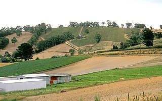
Cromer is a locality in the Adelaide Hills of South Australia. It spans the boundary between the Adelaide Hills Council and the Barossa Council northwest of Mount Pleasant and includes the Cromer Conservation Park.

References

  1. Australian Bureau of Statistics (25 October 2007). Mount Pleasant (L) (Urban Centre/Locality). 2016 Census Quickstats. Retrieved on 2008-05-29
  2. "SOUTH AUSTRALIA". The Australian. 27 March 1838. p. 3.
  3. Travel – Mount Pleasant, Sydney Morning Herald , 8 February 2004. Accessed 18 June 2006.
  4. "Cottage & Barn". South Australian Heritage Register. Department of Environment, Water and Natural Resources. Retrieved 28 May 2016.
  5. "Mount Pleasant Police Station & Cells". South Australian Heritage Register. Department of Environment, Water and Natural Resources. Retrieved 28 May 2016.
  6. "Rosebank Shearing Shed". South Australian Heritage Register. Department of Environment, Water and Natural Resources. Retrieved 28 May 2016.
  7. White Pages Online. Accessed 18 June 2006.
  8. Timetable, Affordable Coachlines. Accessed 15 June 2006
  9. Timetable Archived 17 June 2006 at the Wayback Machine , Barossa Valley Coachlines. Accessed 18 June 2006
  10. Sallis, Roger (1998). Railways in the Adelaide Hills, 1st edition. Openbook Publishers, Adelaide. ISBN   0-646-35473-6.
  11. The Mount Pleasant Line Callaghan, W.H. Australian Railway Historical Society Bulletin, October, 1994 pp274-281

Further reading