
Boneo is a rural locality south of Melbourne, Victoria, Australia, south of and inland from Rosebud on the Mornington Peninsula. Its local government area is the Shire of Mornington Peninsula.
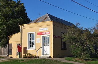
Harcourt is a small Central Highlands town located approximately 9 km northeast of Castlemaine, where the Midland Highway meets the Calder Highway. At the 2016 census, Harcourt had a population of 943.
Mount Kuring-gai is an outer suburb of Northern Sydney, in the state of New South Wales, Australia. Mount Kuring-gai is located 31 kilometres north-west of the Sydney central business district, in the local government area of Hornsby Shire. Mount Kuring-Gai is often referred to as “Far Northern” or Upper North Shore.

Caveside is a rural locality in the local government area of Meander Valley in the Launceston region of Tasmania. The locality is about 45 kilometres (28 mi) south-west of the town of Westbury. It lies between the Great Western Tiers to the south and Mole Creek to the north. The 2016 census has a population of 133 for the state suburb of Caveside.

Mount Garnet is a rural town and locality in the Tablelands Region, Queensland, Australia. In the 2016 census, Mount Garnet had a population of 430 people.
Mount Molloy is a historic mining and timber town and locality lying 55 kilometres (34 mi) north of Cairns in Queensland, Australia. It is within the local government area of Shire of Mareeba.

Eden Park is a locality in Victoria, Australia, 45 km north of Melbourne's central business district. Its local government area is the City of Whittlesea. At the 2016 Census, Eden Park had a population of 1,204.

Rosewood is a village community and locality in the south east part of the Riverina, New South Wales, Australia. It is situated about 16 kilometres (9.9 mi) south east from Carabost and 19 kilometres (12 mi) north west from Tumbarumba. At the 2016 census, Rosewood had a population of 214. The village is administered by two local governments; the northern part of the locality by the Greater Hume Shire and the southern part of the locality by the Snowy Valleys Council. The village of Rosewood is within the Snowy Valleys Council area.

Hungerford is an outback town in the Shire of Bulloo and a locality in the Shire of Bulloo and Shire of Paroo, South West Queensland, Australia. It is immediately north of the border with New South Wales and the Dingo fence. At the 2016 census, Hungerford and the surrounding area within Queensland had a population of 23. The locality of Hungerford on the New South Wales side of the border had a population of 15.

Flowerdale is a town in Victoria, Australia. It is in the Shire of Murrindindi local government area, 95 kilometres (59 mi) from the state capital, Melbourne and in the foothills of the Great Dividing Range, in the upper catchment of the Goulburn River system. At the 2016 Census, Flowerdale had a population of 689.

Mundoo is a town and locality in the Cassowary Coast Region, Queensland, Australia.

Karara is a town and locality in the Darling Downs region within the Queensland, Australia. It is in the Southern Downs Region local government area. In the 2016 census, Karara had a population of 123 people.
Bullyard is a small rural town and locality in Bundaberg Region, Queensland, Australia. In 2016 census Bullyard had a population of 189 people.

Big Hill is a bounded rural locality in Upper Lachlan Shire to the north of Marulan in the Southern Tablelands of New South Wales, Australia. At the 2016 census, it had a population of 44.

Pennyroyal is a rural locality in Victoria, Australia. Most of the locality is situated in the Surf Coast Shire; a small section is situated in the Shire of Colac Otway. In the 2016 census, Pennyroyal had a population of 86.

Belton is a rural locality in South Australia, located in the District Council of Orroroo Carrieton. It is traversed by the Carrieton-Barata Road, the Carrieton-Belton Road and the Weira Creek. The locality was established on 26 April 2013 in respect to “the long established local name.”
Angas Valley is a small town in the Mid Murray Council on the plains between the Mount Lofty Ranges and the Murray River. It is on the road between Mount Pleasant in the ranges and Walker Flat on the Murray. There are no shops in the town, but there is a community hall and tennis courts. There had previously been a school, which operated from 1891 to 1928. Angas Valley Post Office opened in April 1886, became a receiving office in January 1910, and closed in August 1917.
North Booborowie is a rural locality in the Mid North region of South Australia, situated in the Regional Council of Goyder. It was established in August 2008, when boundaries were formalised for the "long established local name". In early days, the North Booborowie name was sometimes used synonymously with Willalo, which is now gazetted as a separate locality to its north.
Hampden is a rural locality in the Mid North region of South Australia, situated in the Regional Council of Goyder. It was established in August 2000, when boundaries were formalised for the "long established local name". It was named for William Hampden Dutton, brother of Frederick Dutton, who established Anlaby Station.
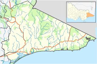
Delegate River is a locality in the Shire of East Gippsland, Victoria, Australia. It is situated on the river of the same name. In the 2016 census, Delegate River had a population of 27 people.
