Krondorf, South Australia

Last updated

Krondorf
South Australia
Krondorf thatched barn.JPG
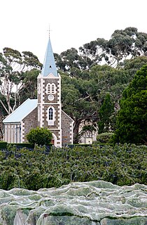
A thatched roof barn in 2006 at Krondorf, South Australia
Australia South Australia location map.svg
Red pog.svg
Krondorf
Coordinates 34°33′39″S138°58′17″E / 34.560770°S 138.971480°E / -34.560770; 138.971480 Coordinates: 34°33′39″S138°58′17″E / 34.560770°S 138.971480°E / -34.560770; 138.971480
Postcode(s) 5352
LGA(s) Barossa Council
State electorate(s) Schubert
Federal Division(s) Barker
Localities around Krondorf:
Tanunda Bethany Angaston
Krondorf Flaxman Valley
Rowland Flat Pewsey Vale Flaxman Valley

Krondorf is a locality in the Barossa Valley in South Australia. The name of the village is derived from the German for Crown's village. [1]

Barossa Valley Region in South Australia

The Barossa Valley is a valley in South Australia located 60 kilometres (37 mi) northeast of Adelaide city centre. The valley is formed by the North Para River. It is notable as a major wine-producing region and tourist destination.

South Australia State of Australia

South Australia is a state in the southern central part of Australia. It covers some of the most arid parts of the country. With a total land area of 983,482 square kilometres (379,725 sq mi), it is the fourth-largest of Australia's states and territories by area, and fifth largest by population. It has a total of 1.7 million people, and its population is the second most highly centralised in Australia, after Western Australia, with more than 77 percent of South Australians living in the capital, Adelaide, or its environs. Other population centres in the state are relatively small; Mount Gambier, the second largest centre, has a population of 28,684.

Prior to 1918, the name of the locality may have been Kronsdorf. In 1918, it was changed to Kabminye (an Australian Aboriginal word for stars) [2] when many Australian placenames were changed to sound less German. An alternate name that was proposed instead of Kabminye was Blennerhassett, in honour of Lady Galway, wife of the Governor of South Australia and daughter of Sir Roland Blennerhassett. [3] It was changed back to Krondorf in 1975. [1]

Marie Galway British womens rights activist

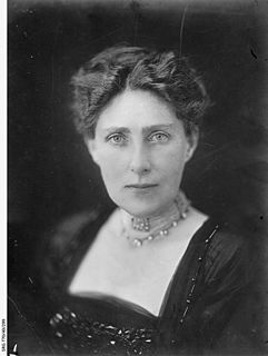
Marie Carola Franciska Roselyne Galway, Lady Galway, CBE, DStJ, née Blennerhassett, was a British charity and civic worker and advocate for women's rights. She was married to Sir Henry Galway, Governor of South Australia.

Governor of South Australia South Australian vice-regal representative of the Australian monarch

The Governor of South Australia is the representative in the Australian state of South Australia of Elizabeth II, Queen of Australia. The Governor performs the same constitutional and ceremonial functions at the state level as does the Governor-General of Australia at the national level. In accordance with the conventions of the Westminster system of parliamentary government, the Governor nearly always acts solely on the advice of the head of the elected government, the Premier of South Australia. Nevertheless, the Governor retains the reserve powers of the Crown, and has the right to dismiss the Premier. As from June 2014, the Queen, upon the recommendation of the Premier, accorded all current, future and living former Governors the title 'The Honourable' for life. The first six Governors oversaw the colony from proclamation in 1836 until self-government and an elected Parliament of South Australia was enacted in the year prior to the inaugural 1857 election.

Sir Rowland Blennerhassett, 4th Baronet was a Roman Catholic Anglo-Irish baronet and Liberal Party politician from County Kerry.

Krondorf (or Kronsdorf) was first settled in 1847 by Germans from nearby Bethany. The Zum Kripplein Christi Lutheran church was built in 1864 and closed in 1955. [4] The church has been renovated by the owners of Charles Melton Wines, a local winery, to provide bed-and-breakfast accommodation. [5]

Bethany, South Australia Town in South Australia

Bethany is a small village about 2 km south-east of Tanunda in the Barossa Valley. It was originally named Bethanien, but was changed during World War I in an attempt to remove all German place names from Australia. Similarly, the German-language school was forced to close by the state government in 1917, with 60 students at the time.

Charles Melton Wines

Charles Melton Wines is an Australian winery based in Tanunda, within the Barossa Valley wine region of South Australia.

Related Research Articles

City of Port Augusta Local government area in South Australia

The City of Port Augusta is a local government area located at the northern end of Spencer Gulf in South Australia. It is centred on the town of Port Augusta. The city was the site of South Australia's main power supplier, the Port Augusta powerhouse, located on the coast of the Spencer Gulf.

Kudla, South Australia Suburb of Gawler, South Australia

Kudla is a locality in the northern Adelaide suburbs, 34 km from the city centre, just south of Gawler. It is in the Town of Gawler local government area.

Cadell, South Australia Town in South Australia

Cadell is a town and locality situated near the north western edge of South Australia's Riverland on the inside of the large southward bend in the Murray River. It is named after Captain Francis Cadell, a pioneer of steam-powered navigation on the Murray River. The town of Cadell was surveyed in 1919 and named in 1920. It is slightly upstream of the earlier failed village settlement of New Era, however what is now the Cadell Irrigation Area is the same as was previously the New Era irrigation area.

Kaiserstuhl Conservation Park Protected area in South Australia

The Kaiserstuhl Conservation Park is a protected area located in the Australian state of South Australia in the suburb of Flaxman Valley about 80 kilometres (50 mi) north-east of the state capital of Adelaide and about 12 kilometres (7.5 mi) south-east of the town of Tanunda.

Callington, South Australia Town in South Australia

Callington is a small town on the eastern slopes of the Adelaide Hills, in South Australia. Callington is situated on the Bremer River, and is adjacent to the South Eastern Freeway and the Adelaide-Wolseley railway line, however no trains have stopped at the station for many years. Callington is located within the state electoral district of Kavel and the federal division of Mayo.

Cooltong, South Australia Town in South Australia

Cooltong is a town and locality in the Australian state of South Australia. At the 2011 census, Cooltong had a population of 317.

Moculta, South Australia Suburb of Barossa Council, South Australia

Moculta is a locality in the Australian state of South Australia located about 69 kilometres (43 mi) north-east of the state capital of Adelaide and about 12 kilometres (7.5 mi) north-east of the municipal seat of Angaston. At the 2016 census, Moculta shared a population of 227 with part of Truro).

Perponda, South Australia Town in South Australia

Perponda is a town and locality in the Australian state of South Australia located about 111 kilometres (69 mi) east of the state capital of Adelaide.

Ramco, South Australia Town in South Australia

Ramco is a town in the Riverland region of South Australia 170 kilometres (110 mi) north-east of the state capital, Adelaide and 7 kilometres (4.3 mi) west of Waikerie. At the 2016 census, Ramco had a population of 166. It is on the south (left) bank of the Murray River downstream from Waikerie.

Springton, South Australia Town in South Australia

Springton is a settlement in South Australia. At the 2011 census, Springton had a population of 607. It draws its name from Springs Dairy which was on the site before the town subdivision was surveyed.

Sandergrove, South Australia Town in South Australia

Sandergrove is a locality in the Australian state of South Australia about 9km south of Strathalbyn. It was a junction on the Victor Harbor railway line, where the Milang railway line branched off. The railway was authorised in 1881 and closed in 1970.

Buchfelde, South Australia Town in South Australia

Buchfelde is now a suburb of Gawler, South Australia, on the northern outskirts of Adelaide in South Australia. A property in the area was settled in 1848 by Dr. Richard von Schomburgk and his brother Otto, and is named after their financial benefactor Leopold von Buch who helped them flee Germany. The name was changed from Buchfelde to Loos in 1918 after a town in France which was the site of a battle in 1915. This was to remove a "name of enemy origin". The name returned to Buchfelde in November 1990.

Bungama, South Australia Town in South Australia

Bungama is a locality to the east of Port Pirie in the Mid North region of South Australia. It contains the intersection that is the southern entrance to Port Pirie from the Augusta Highway ) onto Warnertown Road, and is bisected by the Adelaide-Port Augusta railway line. It also contains a regional 275kV electricity substation operated by ElectraNet. Bungama is on the plains to the west of the Southern Flinders Ranges.

Claypans, South Australia Town in South Australia

Claypans is a locality in the Murray Mallee region of South Australia. Claypans had a Methodist church in 1928. The school opened in 1907 and closed in 1947. The name refers to the claypan at which the settlers camped on their first night.

Edillilie, South Australia Town in South Australia

Edillilie is a small town on Eyre Peninsula in South Australia. It is on the Tod Highway and Eyre Peninsula Railway north of Port Lincoln.

Elwomple, South Australia Town in South Australia

Elwomple is a locality in The Coorong District Council in the South Australian Murray Mallee, southeast of Tailem Bend. The northwest corner is the junction of the Mallee Highway which forms the northern boundary of Elwomple, and the Dukes Highway which forms the southwestern boundary. The Bend Motorsport Park was developed in Elwomple adjacent to this junction. In September 2017, before the facility opened, the boundary between Tailem Bend and Elwomple was adjusted so that The Bend Motorsport Park was officially in Tailem Bend, not Elwomple.

Stockyard Creek, South Australia Suburb of Wakefield Regional Council, South Australia

Stockyard Creek is a locality between Hamley Bridge and Owen, South Australia in the Mid North region of South Australia. It was established on the Hamley Bridge to Balaklava railway at the site of stockyards used by CB Fisher, 51 34 miles (83.3 km) north of Adelaide railway station. A private subdivision was surveyed, and there was a post office near the station, but very little remains now.

Kybunga, South Australia Town in South Australia

Kybunga is a locality in the Mid North of South Australia. It was on the Gladstone railway line 87 12 miles (140.8 km) north of Adelaide on the plains to the west of the Clare Valley. Kybunga school opened in 1881 and closed in 1988. The former Methodist and Uniting church opened in 1886 and is now a private residence.

Gomersal, South Australia Town in South Australia

Gomersal is a locality on the western side of the Barossa Valley in South Australia. It is between the Sturt Highway and the North Para River and town of Tanunda on the valley floor. Prior to 1918, it was known as New Mecklenburg, but like many others, the name was changed due to anti-German sentiment in World War I. The new name was derived from the town of Gomersal, West Yorkshire.

Goyder, South Australia Town in South Australia

Goyder is a locality in South Australia's Mid North situated in the central east of the cadastral Hundred of Goyder. It was named for the hundred which was in turn named for George Goyder, Surveyor General of South Australia at the time.

References

  1. 1 2 "Placename Details: Krondorf". Land Services Group, Department of Planning, Transport and Infrastructure, Government of South Australia. 6 February 2007. SA0037771. Retrieved 8 February 2015.
  2. "Placename Details: Kabminye". Land Services Group, Department of Planning, Transport and Infrastructure, Government of South Australia. 6 February 2007. SA0033366. Retrieved 8 February 2015.
  3. "Placename Details: Blennerhassett". Land Services Group, Department of Planning, Transport and Infrastructure, Government of South Australia. 27 August 2009. SA0032806. Retrieved 8 February 2015.
  4. "Krondorf, South Australia". Graeme Moad. Retrieved 8 February 2015.
  5. "Introducing The Kirche @ Charles Melton" . Retrieved 8 February 2015.