
Nobby is a rural town and locality on the Darling Downs in the Toowoomba Region, Queensland, Australia. It is located halfway between Toowoomba and Warwick. It is known for its association with Steele Rudd (author) and Sister Elizabeth Kenny.

The District Council of Loxton Waikerie is a local government area in the Murray Mallee region of South Australia. The council seat lies at Loxton, while it maintains a branch office at Waikerie.
Eudlo is a rural town and locality in the Sunshine Coast Region, Queensland, Australia. In the 2021 census, the locality of Eudlo had a population of 1,192 people.
The District Council of Loxton was a local government area in South Australia from 1910 to 1997, centring on the town of Loxton.

Moorook is a small town in the Australian state of South Australia, one of a series of towns surrounding lakes in the Riverland region.

Wanbi is a township on the Karoonda Highway in the Australian state of South Australia, about 160 kilometres (99 mi) east of the state capital of Adelaide and about 56 kilometres (35 mi) north-east of the municipal seat of Karoonda. Situated on a ridgeline covered by mallee trees, it has a one-street layout common to many South Australian townships. A hotel, advertised as being "in the heart of the scrub, stumps and sand", was built in 1932, when commercial activity was increasing and a general store, cream depot and several houses – most housing South Australian Railways employees – were present.

Bowenville is a rural town and locality in the Toowoomba Region, Queensland, Australia. The town's economy rested on the rail industry and with the winding down of the railways the population declined. In the 2021 census, the locality of Bowenville had a population of 219 people.

Ideraway is a rural town and locality in the North Burnett Region, Queensland, Australia. In the 2021 census, the locality of Ideraway had a population of 31 people.

Baree is a rural locality in the Rockhampton Region, Queensland, Australia. In the 2021 census, Baree had a population of 201 people.

The Yinkanie railway line was a 50.6 kilometres (31.4 mi) railway line on the South Australian Railways network. Named the Wanbi to Moorook Railway in its enabling Act, it never reached its intended destination on the River Murray. The railway ran from a junction with the Barmera line at Wanbi northwards to Yinkanie, opening on 7 September 1925 and closing on 1 May 1971.
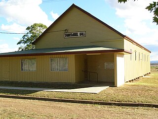
Tannymorel is a rural town and locality in the Southern Downs Region, Queensland, Australia. In the 2021 census, the locality of Tannymorel had a population of 148 people.

Eba is a locality in the Murray Mallee region of South Australia, between the Mount Lofty Ranges and the Murray River. It is on the Thiele Highway and was on the Morgan railway line, 10 kilometres (6.2 mi) southwest of Morgan near the northwest bend of the Murray River.
Wetheron is a rural town and locality in the North Burnett Region, Queensland, Australia. In the 2021 census, the locality of Wetheron had a population of 40 people.

Willows is a rural locality in the Central Highlands Region, Queensland, Australia. In the 2021 census, Willows had a population of 139 people.
Owanyilla is a rural town and locality in the Fraser Coast Region, Queensland, Australia. In the 2021 census, the locality of Owanyilla had a population of 245 people.

Goomburra is a rural town and locality in the Southern Downs Region, Queensland, Australia. In the 2021 census, the locality of Goomburra had a population of 256 people.
Caliph is a locality in the Murray Mallee region of South Australia. Its name was derived from a variety of wheat grown in the area.
Wappilka is a locality in the Murray Mallee region of South Australia.

Yinkanie is a locality, formerly a small settlement established at the terminus of the Moorook railway line, in the Murraylands region of South Australia near the River Murray. The railway line opened in 1925 and closed in 1971; it was never extended to the river.
Monteith railway station was located in the locality of Monteith, about 110 kilometres from Adelaide station.

