Maggea, South Australia

Last updated

Maggea
South Australia
Maggea railway sign.JPG
Australia South Australia location map.svg
Red pog.svg
Maggea
Coordinates 34°28′37″S140°03′53″E / 34.47698°S 140.064645°E / -34.47698; 140.064645 Coordinates: 34°28′37″S140°03′53″E / 34.47698°S 140.064645°E / -34.47698; 140.064645 [1]
Population12 (2016 census) [2]
Established1915 (town) [1]
Postcode(s) 5311
Elevation63 m (207 ft)
Time zone ACST (UTC+9:30)
 • Summer (DST) ACDT (UTC+10:30)
Location45 km (28 mi) E of Swan Reach
LGA(s) District Council of Loxton Waikerie [1]
Region Murray and Mallee [1]
County Albert [1]
State electorate(s) Chaffey [3]
Federal Division(s) Barker [4]
Localities around Maggea:
New Well Boolgun, Waikerie Wappilka
Naidia, Swan Reach Maggea Wunkar
Galga, Bakara Mercunda Mantung

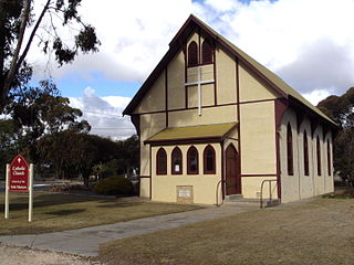
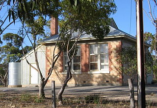
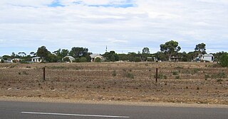
Maggea is a locality and former settlement in the Murray Mallee region of South Australia. It is on the Stott Highway between Swan Reach and Loxton and was on the former Waikerie railway line. The town is almost deserted now that the railway line has closed.

The Murray Mallee is the grain-growing and sheep-farming area of South Australia bounded to the north and west by the Murray River, to the east by the Victorian border, and extending about 50 km south of the Mallee Highway.

South Australia State of Australia

South Australia is a state in the southern central part of Australia. It covers some of the most arid parts of the country. With a total land area of 983,482 square kilometres (379,725 sq mi), it is the fourth-largest of Australia's states and territories by area, and fifth largest by population. It has a total of 1.7 million people, and its population is the second most highly centralised in Australia, after Western Australia, with more than 77 percent of South Australians living in the capital, Adelaide, or its environs. Other population centres in the state are relatively small; Mount Gambier, the second largest centre, has a population of 28,684.

Stott Highway

The Stott Highway is the road from Angaston through Sedan and Swan Reach to Loxton in South Australia. It was named after Tom Stott, a long-time farmer in and member of state parliament for areas traversed by the highway in 2008.

Maggea was named in 1915 after the local Aboriginal Australian name for camp. [1] The school operated in the hall from 1919 to 1967. [5]

Maggea hall building showing 1919 date of first use Maggea Hall.JPG
Maggea hall building showing 1919 date of first use

The 2016 Australian census which was conducted in August 2016 reports that Maggea had a population of 12 people. [2]

The 2016 Australian census was the seventeenth national population census held in Australia. The census was officially conducted with effect on Tuesday, 9 August 2016. The total population of the Commonwealth of Australia was counted as 23,401,892 – an increase of 8.8 per cent or 1,894,175 people since the 2011 census. Norfolk Island joined the census for the first time in 2016, adding 1,748 to the population.

Related Research Articles

Karoonda, South Australia Town in South Australia

Karoonda is in the middle of the Murray Mallee region of South Australia. Karoonda takes its name from the Aboriginal word for "winter camp". The current boundaries include the former town of Lowaldie, which was the next stop on the railway line away from Adelaide.

Parilla, South Australia Town in South Australia

Parilla is a town and a locality in the Australian state of South Australia located in the state's Murray Mallee region about 192 kilometres (119 mi) east of the state capital of Adelaide, about 32 kilometres (20 mi) west of the municipal seat of Pinnaroo and about 14 kilometres (8.7 mi) east of the town of Lameroo.

Lameroo, South Australia Town in South Australia

Lameroo is a town in the Murray Mallee region of South Australia. It is on the Mallee Highway and Pinnaroo railway line about 40 km west of the Victorian border, or 210 km east of Adelaide. It is primarily a service town for the surrounding rural areas, growing grain and sheep. Lameroo now includes the former settlements of Kulkami, Mulpata, Wirha and Gurrai, which were on the Peebinga railway line, and Wilkawatt, which was between Parrakie and Lameroo on the Pinnaroo railway.

Jabuk, South Australia Town in South Australia

Jabuk is a locality in the Australian state of South Australia located about 142 kilometres (88 mi) south-east of the state capital of Adelaide and respectively about 78 kilometres (48 mi) west and 58 kilometres (36 mi) east of the municipal seats of Pinnaroo and Tailem Bend.

Marama, South Australia Town in South Australia

Marama is a town and a locality in the Australian state of South Australia located in the state's south-east about 146 kilometres (91 mi) east of the state capital of Adelaide and about 28 kilometres (17 mi) east of the municipal seat of Karoonda.

Wynarka, South Australia Town in South Australia

Wynarka is a very small town in South Australia 120 kilometres (75 mi) southeast of Adelaide on the Karoonda Highway (B55) and Loxton railway line in the Murray Mallee. Wynarka lies within the District Council of Karoonda East Murray.

Parrakie, South Australia Town in South Australia

Parrakie, South Australia is a small town on the Mallee Highway and Pinnaroo railway line approximately 26 kilometres west of Lameroo. The name is derived from the Aboriginal word perki which means cave or limestone sink hole. The town was surveyed in 1907.

Borrika, South Australia Town in South Australia

Borrika is a town and locality in South Australia. It is on the Karoonda Highway 16 kilometres (9.9 mi) east of Karoonda, and was on the Barmera railway line, later known as the Loxton railway line when the end of the main line closed but the Loxton branch remained open until 2015 and has now also closed.

Burrungule, South Australia Town in South Australia

Burrungule is a locality in South Australia.

Galga, South Australia Town in South Australia

Galga is a settlement in the northern Murray Mallee region of South Australia. The town of Galga was surveyed in 1915 after the Waikerie railway line from Karoonda to Waikerie was opened in 1914. The line was shortened to Galga in 1990, and closed completely in 1994. There is a small bulk grain silo at Galga, but it is no longer regularly used. Galga has an active Country Fire Service brigade with one fire truck.

Perponda, South Australia Town in South Australia

Perponda is a town and locality in the Australian state of South Australia located about 111 kilometres (69 mi) east of the state capital of Adelaide.

Sandalwood, South Australia Town in South Australia

Sandalwood is a town and locality in the Australian state of South Australia located about 139 kilometres (86 mi) east of the state capital of Adelaide.

Wanbi, South Australia Town in South Australia

Wanbi is a town and locality in the Australian state of South Australia located about 157 kilometres (98 mi) east of the state capital of Adelaide and about 56 kilometres (35 mi) north-east of the municipal seat of Karoonda.

Peebinga, South Australia Town in South Australia

Peebinga is a town and locality in the Australian state of South Australia. Peebinga was the terminus of the Peebinga railway line which was built in 1914 as part of a major state government project to open up the Murray Mallee for grazing and cropping.

Mantung, South Australia Town in South Australia

Mantung is a town and a locality in the Australian state of South Australia located in the state's south-east about 140 kilometres (87 mi) east of the state capital of Adelaide, and about 58 kilometres (36 mi) north-east and about 48 kilometres (30 mi) south-west respectively of the municipal seats of Karoonda and Loxton.

Mount Mary, South Australia Town in South Australia

Mount Mary is a small town on the Thiele Highway between Eudunda and Morgan in South Australia. It was also served by the Morgan railway line from 1878 until 1969 and is named for the Mount Mary railway station on that line.

Suttontown, South Australia Town in South Australia

Suttontown is a hamlet located immediately north of Mount Gambier in the south-east of South Australia.

Yantanabie, South Australia Town in South Australia

Yantanabie is a town and rural locality in the wheat belt of South Australia, 37 miles inland from Streaky Bay, South Australia.

Mercunda, South Australia Town in South Australia

Mercunda is a town and a locality in the Australian state of South Australia located in the state's south-east about 134 kilometres (83 mi) east of the state capital of Adelaide, and about 52 kilometres (32 mi) north-east and about 53 kilometres (33 mi) south-west respectively of the municipal seats of Karoonda and Loxton.

Kringin, South Australia Suburb of District Council of Loxton Waikerie , South Australia

Kringin is a town and a locality in the Australian state of South Australia located in the state’s east about 199 kilometres (124 mi) east of the state capital of Adelaide and about 61 kilometres (38 mi) south of the municipal seat of Loxton.

References

  1. 1 2 3 4 5 6 "Search results for 'Maggea, LOCB' with the following datasets being selected - 'Suburbs and Localities', 'Government Towns', 'Counties', 'Local Government Areas', 'SA Government Regions', 'Railways' and 'Gazetteer'". Location SA Map Viewer. Government of South Australia. Retrieved 7 May 2018.
  2. 1 2 Australian Bureau of Statistics (27 June 2017). "Maggea". 2016 Census QuickStats. Retrieved 7 May 2018. OOjs UI icon edit-ltr-progressive.svg
  3. "District of Chaffey (map)". Electoral Commission SA. Retrieved 7 May 2018.
  4. "Federal electoral division of Barker, boundary gazetted 16 December 2011" (PDF). Australian Electoral Commission. Retrieved 17 September 2015.
  5. Plaque on hall building. file:Plaque on Maggea hall.JPG, photographed 1 February 2015