
Kingston On Murray is a town on the south bank of the Murray River in the Riverland region of South Australia. Its name is ultimately derived from Charles Kingston who was Premier of South Australia from 1893-99. At the 2006 census, the town had a population of 257.
Nildottie is a locality in the Australian state of South Australia located on the east side of the Murray River about 99 kilometres (62 mi) east of the state capital of Adelaide and about 40 kilometres (25 mi) north-east of the municipal seat in Mannum.
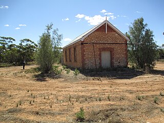
Borrika is a town and locality in South Australia. It is on the Karoonda Highway 16 kilometres (9.9 mi) east of Karoonda, and was on the Barmera railway line, later known as the Loxton railway line when the end of the main line closed but the Loxton branch remained open until 2015 and has now also closed.
Galga is a settlement in the northern Murray Mallee region of South Australia. The town of Galga was surveyed in 1915 after the Waikerie railway line from Karoonda to Waikerie was opened in 1914. The line was shortened to Galga in 1990, and closed completely in 1994. There is a small bulk grain silo at Galga, but it is no longer regularly used. Galga has an active Country Fire Service brigade with one fire truck.

Ramco is a town in the Riverland region of South Australia 170 kilometres (110 mi) north-east of the state capital, Adelaide and 7 kilometres (4.3 mi) west of Waikerie. At the 2016 census, Ramco had a population of 166. It is on the south (left) bank of the Murray River downstream from Waikerie.

Paruna is a town in eastern South Australia. The town is located on the Browns Well Highway, where it crosses the former Barmera railway line, 237 kilometres (147 mi) east of the state capital, Adelaide.
Peebinga is a town and locality in the Australian state of South Australia. Peebinga was the terminus of the Peebinga railway line which was built in 1914 as part of a major state government project to open up the Murray Mallee for grazing and cropping.
Maggea is a town and locality in the Murray Mallee region of South Australia. It is on the Stott Highway between Swan Reach and Loxton and was on the former Waikerie railway line. The town is almost deserted now that the railway line has closed.

Ngarkat is a locality in the Australian state of South Australia located in the south-east of the state at the border with the state of Victoria in both the Murray Mallee and the Limestone Coast regions about 227 kilometres south east of the state capital of Adelaide.
Mantung is a town and a locality in the Australian state of South Australia located in the state's south-east about 140 kilometres (87 mi) east of the state capital of Adelaide, and about 58 kilometres (36 mi) north-east and about 48 kilometres (30 mi) south-west respectively of the municipal seats of Karoonda and Loxton.
Taylorville Station is a locality in the Australian state of South Australia located about 250 kilometres north-east of the Adelaide and about 35 kilometres to the north-west of the municipal seat of Renmark.

Katarapko is a locality in the Australian state of South Australia located in the Riverland about 188 kilometres north-east of the state capital of Adelaide and about 6.6 kilometres (4.1 mi) north of Loxton.
Spectacle Lake is a locality in the Australian state of South Australia located in the Riverland on the northern side of the Murray River about 180 kilometres north-east of the Adelaide city centre and about 16 kilometres (9.9 mi) northwest of Loxton. Its boundaries were created in August 1999 along with the selection of its name which was derived from the Spectacle Lakes, a lake system which is situated within the locality on the floodplain of the Murray River. In 2014, a portion of Spectacle Lake was removed and added to the adjoining locality of Loveday to ensure the full extent of Nynes Island is within Loveday. As of 2012, the land use within Spectacle Lake was divided between conservation and agriculture with the former being concerned with the floodplain. Spectacle Lake is located within the federal division of Barker, the state electoral district of Chaffey and the unincorporated area of South Australia.
Gerard is a locality in the Australian state of South Australia located in the Riverland on the northern side of the Murray River about 182 kilometres north-east of the state capital of Adelaide and about 12 kilometres (7.5 mi) northwest of Loxton.
Sunlands is a locality on the left bank of the Murray River, 10 kilometres (6.2 mi) west of Waikerie, South Australia. The Waikerie Golf and Country Club course is in Sunlands.
Mercunda is a town and a locality in the Australian state of South Australia located in the state's south-east about 134 kilometres (83 mi) east of the state capital of Adelaide, and about 52 kilometres (32 mi) north-east and about 53 kilometres (33 mi) south-west respectively of the municipal seats of Karoonda and Loxton.
Mundic Creek is a locality in the Australian state of South Australia located in the Riverland in the state’s east on the southern side of the Murray River about 217 kilometres (135 mi) north-east of the state capital of Adelaide, and about 6 kilometres (3.7 mi) south-east of the municipal seat of Renmark.
Pike River is a locality in the Australian state of South Australia located in the Riverland in the state’s east on the southern side of the Murray River about 210 kilometres (130 mi) north-east of the state capital of Adelaide and about 9 kilometres (5.6 mi) south-east of the municipal seat of Renmark.
Kringin is a town and a locality in the Australian state of South Australia located in the state’s east about 199 kilometres (124 mi) east of the state capital of Adelaide and about 61 kilometres (38 mi) south of the municipal seat of Loxton.
Pooginook is a locality in the Australian state of South Australia located in the state’s east about 167 kilometres (104 mi) north-east of the state capital of Adelaide and about 60 kilometres (37 mi) north-west of the municipal seat in Loxton.
