
Murray Bridge is a city in the Australian state of South Australia, located 78 kilometres (48 mi) east-southeast of the state's capital city, Adelaide, and 77 kilometres (48 mi) north of the town of Meningie.

The District Council of Loxton Waikerie is a local government area in the Murray Mallee region of South Australia. The council seat lies at Loxton, while it maintains a branch office at Waikerie.
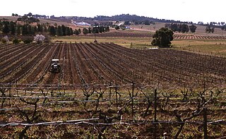
Pokolbin is a rural locality in the Hunter Region of New South Wales Australia. It is part of the Singleton Council local government area and the city of Cessnock. The area is the centre of the Lower Hunter Valley wine region. Pokolbin lies within the Hunter Valley Important Bird Area.

Coorong is a locality in the Australian state of South Australia which is associated with the lagoon known as the Coorong in the south-east of the state and which overlooks the continental coastline from the mouth of the Murray River about 80 kilometres south-east of the state capital of Adelaide to the immediate north of the town of Kingston SE extending for a distance of at least 140 kilometres (87 mi).

Tanah Merah is a residential suburb in the City of Logan, Queensland, Australia. It was officially named by the Queensland Place Names Board in 1971. In the 2021 census, Tanah Merah had a population of 4,754 people.
Nildottie is a locality in the Australian state of South Australia located on the east side of the Murray River about 99 kilometres (62 mi) east of the state capital of Adelaide and about 40 kilometres (25 mi) north-east of the municipal seat in Mannum.

Upper Caboolture is a rural locality in the City of Moreton Bay, Queensland, Australia. In the 2016 census, Upper Caboolture had a population of 4214 people. Formerly a rural area on the fringe of the town of Caboolture, since the 1990s the suburb has become increasingly urbanised.
In South Australia, one of the states of Australia, there are many areas which are commonly known by regional names. Regions are areas that share similar characteristics. These characteristics may be natural such as the Murray River, the coastline, desert or mountains. Alternatively, the characteristics may be cultural, such as common land use. South Australia is divided by numerous sets of regional boundaries, based on different characteristics. In many cases boundaries defined by different agencies are coterminous.
North Eton is a rural locality in the Mackay Region, Queensland, Australia. In the 2016 census North Eton had a population of 186 people.

NNeales Flat is a rural locality southeast of Eudunda in the Mid North region in South Australia. It is in the Regional Council of Goyder local government area, the South Australian House of Assembly electoral district of Stuart and the Australian House of Representatives Division of Grey.

Jimbour East is a rural locality in the Western Downs Region, Queensland, Australia. In the 2016 census Jimbour East had a population of 199 people. The town of Jimbour in the locality.
Murrays Bridge is a rural locality in the Southern Downs Region, Queensland, Australia. In the 2016 census Murrays Bridge had a population of 103 people.

Murray Upper is a rural locality in the Cassowary Coast Region, Queensland, Australia. In the 2016 census Murray Upper had a population of 266 people.
Mercunda is a town and a locality in the Australian state of South Australia located in the state's south-east about 134 kilometres (83 mi) east of the state capital of Adelaide, and about 52 kilometres (32 mi) north-east and about 53 kilometres (33 mi) south-west respectively of the municipal seats of Karoonda and Loxton.
Meningie West is a locality in the Australian state of South Australia located in the state’s south-east about 99 kilometres (62 mi) south-east of the state capital of Adelaide and about 50 kilometres (31 mi) south-west of the municipal seat in Tailem Bend.

Glen Boughton is a rural locality in the Cairns Region, Queensland, Australia. In the 2021 census, Glen Boughton had a population of 19 people.
Wombats Rest is a locality in the Australian state of South Australia located in the state’s east on the western side of the Murray River about 133 kilometres (83 mi) north-east of the state capital of Adelaide and about 94 kilometres (58 mi) north-east of the municipal seat of Mannum.
McBean Pound is a locality in the Australian state of South Australia located in the Riverland in the state’s east on the western side of the Murray River about 118 kilometres (73 mi) north-east of the state capital of Adelaide about 76 kilometres (47 mi) north-east of the municipal seat of Mannum.
Bilyana is a coastal locality in the Cassowary Coast Region, Queensland, Australia. In the 2021 census, Bilyana had a population of 190 people.
Erakala is a mixed-use locality in the Mackay Region, Queensland, Australia. In the 2021 census, Erakala had a population of 763 people.
