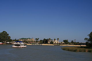
Renmark is a town in South Australia's rural Riverland area, and is located 254 km (157.83 mi) northeast of Adelaide, on the banks of the River Murray. The Sturt Highway between Adelaide and Sydney runs through the town; Renmark is the last major town encountered in South Australia when driving this route. It is 31 m (101.71 ft) above sea level. At the 2016 census, Renmark had a population of 4,634.

Birdwood is a town near Adelaide, South Australia. It is located in the local government areas of the Adelaide Hills Council and the Mid Murray Council.

Hahndorf is a small town in the Adelaide Hills region of South Australia. Currently an important tourism spot, it has previously been a centre for farming and services.

The Riverland is a region of South Australia. It covers an area of 9,386 square kilometres (3,624 sq mi) along the River Murray from where it flows into South Australia from New South Wales and Victoria downstream to Blanchetown. The major town centres are Renmark, Berri, Loxton, Waikerie, Barmera and Monash, and many minor townships. The population is approximately 35,000 people.
Loxton is a town on the south bank of the River Murray in the Riverland region of South Australia. It is located on the lands of the Erawirung people who occupied the area before European colonisation.
Gatton is a rural town and locality in the Lockyer Valley Region, Queensland, Australia. In the 2016 census, the locality of Gatton had a population of 7,101 people.

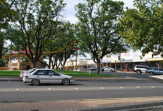
Waikerie is a rural town in the Riverland region of South Australia on the south bank of the Murray River. At the 2016 census, Waikerie had a population of 2,684. The Sturt Highway passes to the south of the town at the top of the cliffs. There is a cable ferry crossing the river to provide vehicle access from the north side of the river. Waikerie is known for citrus growing, along with stone fruit and grapes.

August Ludwig Christian Kavel was a founder of Lutheranism in Australia.

Yalata is an Aboriginal community located 200 kilometres (120 mi) west of Ceduna and 140 km (87 mi) south of Ooldea on the edge of the Nullarbor Plain in South Australia. It lies on the traditional lands of the Wirangu people, but the settlement began as Yalata Mission in the early 1950s when Pila Nguru people were moved from Ooldea Mission when that closed, after previously being moved from their land in the Great Victoria Desert owing to nuclear testing by the British Government.

Sedan is a rural town in South Australia. It is located about 100 kilometres east of Adelaide and about 20 kilometres west of the Murray River. It is located on the dry eastern side of the Mount Lofty Ranges.

Waterloo is a settlement in South Australia, located just off the Barrier Highway between Manoora and Black Springs, approximately 121 kilometres (75 mi) north-east of the state capital of Adelaide.

Bethel is a locality and former settlement in South Australia, west of Kapunda. Its name means Place of God.

Steinfeld is a locality in South Australia on the plains east of the Mount Lofty Ranges, and north of the Sturt Highway. The village of Steinfeld was established in the 19th century. It was renamed to Stonefield in 1918 as many places with German or German-sounding names were changed around World War I. The name reverted to Steinfeld in 1986.

Murtho is a locality in South Australia. It is northeast of Renmark and Paringa. It is bounded by the Murray River on its north and west sides and the Victorian border on the east.
Sandleton is a locality and former town in South Australia. It is located on the plains on the eastern side of the Mount Lofty Ranges. The current boundaries for the locality were created in 2003 for the long-established name of the area.
Dalkey is a locality in the Mid North of South Australia. It was established as a private subdivision of section 171 in the Hundred of Dalkey on the main road from Adelaide to Balaklava. It is named for the Hundred of Dalkey which in turn was named after Dalkey in Ireland. The boundaries of the locality were defined in 2000 for the long-established name.
Emu Downs is a rural locality in the Mid North region of South Australia, situated in the Regional Council of Goyder.
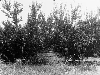
Holder is a locality in the Riverland region of South Australia. It lies on the inside of a bend in the Murray River east (upstream) of Waikerie. Holder is bounded on the south side by the Sturt Highway and includes the Waikerie Airport and Maize Island Lagoon Conservation Park. The locality includes low-lying wetlands near river level and rising and higher ground up to the level at the top of the Murray cliffs where the airport and highway are. The sloping and higher ground is used for vineyards and fruit orchards, irrigated from the river. The school opened in 1925 and closed in 1991.
Carl Heinrich Conrad Loessel or Lössel, generally known as Carl or Carl Heinrich Loessel, was a German-born Lutheran pastor and schoolteacher in the early days of the British colony of South Australia. He was a founder of the Lutheran Church in Flinders Street, Adelaide, and pastor of the church at Lobethal.
