
Murray River National Park is a protected area in South Australia located between 180 kilometres (110 mi) and 240 km (150 mi) north east of the Adelaide city centre. The national park was proclaimed in 1972 "to conserve a significant proportion of South Australia’s floodplain environments which are not represented widely in other reserve systems." The national park consists of three sections adjoining the Murray River and extending from near Loxton in the south west to near Renmark in the north-east. The first which is known as the ‘Katarapko’ section is located on the north side of the river between Loxton in the south and Berri in the north. The second section which is known as the ‘Lyrup Flats’ section is located on the north side of the river midway between Berri and Loxton. The third section is known as the ‘Bulyong’ section is located on the west side of the river upstream from Renmark. The national park is classified as an IUCN Category VI protected area.

The Riverland is a region of South Australia. It covers an area of 9,386 square kilometres (3,624 sq mi) along the Murray River from where it flows into South Australia from New South Wales and Victoria downstream to Blanchetown. The major town centres are Renmark, Berri, Loxton, Waikerie, Barmera and Monash, along with many minor townships; the population is approximately 35,000 people.
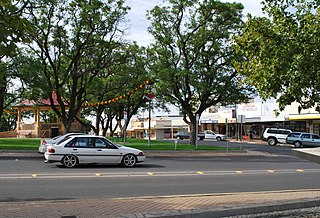
Loxton is a town on the south bank of the River Murray in the Riverland region of South Australia. At the 2016 census, Loxton had a population of 4,568. It is a service town for the surrounding districts. The area near Loxton is a significant citrus fruit and summer fruit growing area. Loxton is also the main town for the northern part of the Murray Mallee which is a dryland farming and grain cropping area.

The District Council of Loxton Waikerie is a local government area in the Murray Mallee region of South Australia. The council seat lies at Loxton, while it maintains a branch office at Waikerie.

Samuel John Everett Loxton, OBE was an Australian cricketer, footballer and politician. Among these three pursuits, his greatest achievements were attained on the cricket field; he played in 12 Tests for Australia from 1948 to 1951. A right-handed all-rounder, Loxton was part of Don Bradman's Invincibles, who went through the 1948 tour of England undefeated, an unprecedented achievement that has never been matched. As well as being a hard-hitting middle-order batsman, Loxton was a right-arm fast-medium swing bowler who liked to aim at the upper bodies of the opposition, and an outfielder with an accurate and powerful throw. After being dropped from the national team, Loxton represented Victoria for seven more seasons before retiring from first-class cricket. He served as an administrator after his playing days were over and spent 24 years as a Liberal Party member of the Victorian Legislative Assembly. Up until 1946, Loxton also played in the Victorian Football League (VFL) for St Kilda as a forward. In all three arenas, he was known for his energetic approach.
The District Council of Loxton was a local government area in South Australia from 1910 to 1997, centring on the town of Loxton.

Borrika is a town and locality in South Australia. It is on the Karoonda Highway 16 kilometres (9.9 mi) east of Karoonda, and was on the Barmera railway line, later known as the Loxton railway line when the end of the main line closed but the Loxton branch remained open until 2015 and has now also closed.

Moorook is a town and locality in Australian state of South Australia. It is part of a series of towns surrounding lakes in the Riverland region in Australia. At the 2006 census, Moorook had a population of 289.
Sandalwood is a small settlement in the Murray Mallee region of South Australia.
Wanbi is a settlement in South Australia.

Paruna is a town in eastern South Australia. The town is located on the Browns Well Highway, where it crosses the former Barmera railway line, 237 kilometres (147 mi) east of the state capital, Adelaide.
The Karoonda Highway is a 172-kilometre-long (107 mi) state-controlled highway in South Australia linking the Murray River towns of Murray Bridge and Loxton. It was created after local councils called for the renaming of the B55 road route.
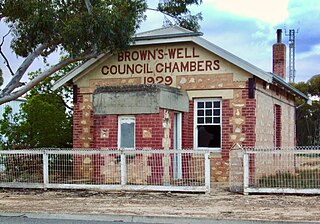
The District Council of Brown's Well was a local government area in South Australia from 1916 to 1997. The name stemmed from the Brown's Well pastoral station, which was located near the council seat of Paruna. Meetings were also held on a regular basis in the institute at Alawoona, which was the district's major centre.
Peebinga is a town and locality in the Australian state of South Australia. Peebinga was the terminus of the Peebinga railway line which was built in 1914 as part of a major state government project to open up the Murray Mallee for grazing and cropping.

Katarapko is a locality in the Australian state of South Australia located in the Riverland about 188 kilometres north-east of the state capital of Adelaide and about 6.6 kilometres (4.1 mi) north of Loxton.
Billiatt is a locality in the Australian state of South Australia located in the south-east of the state in the Murray Mallee region about 168 kilometres north-east of the state capital of Adelaide.
Kapunda Island Conservation Park is a protected area in the Australian state of South Australia located on the Riverland in the gazetted locality of Loxton about 1 kilometre (0.62 mi) north-west of the Loxton town centre.
Pyap is a locality in the Riverland region of South Australia. It is on the left (south) bank of the Murray River about 7 km downstream from Loxton. It includes both flat land near the river and higher land away from it. The environment is dry, so vineyards and orchards are irrigated from the river. It lies on the Kingston Road from Loxton, at the junction with the Stott Highway towards Swan Reach.
Kringin is a town and a locality in the Australian state of South Australia located in the state’s east about 199 kilometres (124 mi) east of the state capital of Adelaide and about 61 kilometres (38 mi) south of the municipal seat of Loxton.
Pooginook is a locality in the Australian state of South Australia located in the state’s east about 167 kilometres (104 mi) north-east of the state capital of Adelaide and about 60 kilometres (37 mi) north-west of the municipal seat in Loxton.


