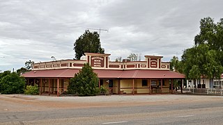
Moorine Rock is located in the eastern agricultural region of Western Australia, 347 km east of Perth and 22 km west south west of Southern Cross.

Halbury is a former railway town in South Australia, west of the Clare Valley, halfway between Balaklava and Auburn. At the 2006 census, Halbury had a population of 363.

Witchcliffe is a small town in the South West region of Western Australia, located a few kilometres south of Margaret River on the Bussell Highway. The name originates from a cave in the area, Witchcliffe cave, that was recorded by a surveyor in 1900. It is believed the name was given by the Bussell family whose property, Wallcliffe, was established in the area in the 1850s.
Benjaberring is a small town in the Wheatbelt region of Western Australia. The name of the town originates from the Aboriginal name of a nearby water source. The name of the area first appears on charts in 1846; the town site was first declared as Benjabbering in 1910, but the spelling was changed to Benjaberring in 1911 to more accurately reflect the correct pronunciation. In 1927 - the wheat statistics were showing over 2,000 tons annually for the years 1924/1925, and 1925/1926.
Lake View is a locality in South Australia beside the Augusta Highway between Snowtown and Redhill. The name is from that of the historic railway siding, Lake View Railway Station, within the locality and refers to the string of small salt lakes at the location, beside Barunga East Road.

Moorook is a town and locality in Australian state of South Australia. It is part of a series of towns surrounding lakes in the Riverland region in Australia. At the 2016 census, Moorook had a population of 189.
Wharminda is a locality in the Australian state of South Australia located on the Eyre Peninsula about 242 kilometres west of the state capital of Adelaide.

Bumbunga is a locality in the Mid North of South Australia 125 kilometres (78 mi) north of Adelaide. It lies 5 kilometres (3.1 mi) east of Lake Bumbunga.

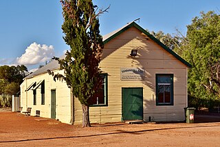
Yandanooka is a small town in the Mid West region of Western Australia. The town is located between Mingenew and Three Springs on the Midlands Road.
The locality of Barinia is situated in South Australia in the Mid North region, approximately 10 km north of Clare. It was a railway siding on the Spalding railway line, which closed in 1984. In November 2009 it became the northern terminus of the Riesling Trail, which utilises the route of the former railway.

Wunkar is a small town in the Murray Mallee region of South Australia. Wunkar was originally a station on the Moorook railway line. The town was surveyed in 1926 after the railway station name was approved in 1925. The railway closed in 1971. Wunkar now lies adjacent to the Stott Highway approximately 27 km west of Loxton. There are bulk grain silos at the former railway station. The school opened in 1925 and closed in 1973.
Edillilie is a small town on Eyre Peninsula in South Australia. It is on the Tod Highway and Eyre Peninsula Railway north of Port Lincoln.
Winninowie is a locality in the Mid North of South Australia. It is traversed by the Augusta Highway which is part of the Australian National Highway on Highway 1. It includes the intersection of Horrocks Pass Road, also known as Main North Road with the main highway. Winninowie is 21 kilometres (13 mi) southeast of Port Augusta, on the plain between Spencer Gulf on the west and the southern Flinders Ranges on the east.
Cunyarie is a locality on northern Eyre Peninsula in South Australia. The Hundred of Cunyarie was proclaimed in 1922 and the town was surveyed in November 1927. Land was released, surveyed and apportioned on an application basis, with the latest sections being surveyed as late as the 1960s and 1970s. However, the limiting factor for early settlers was the availability of water, and allocations were generally preferentially selected around rare rocky outcrops or uplands which could afford some opportunities for increased runoff into earthen dams. Indeed, access to water was a critical factor in European settlement of Eyre Peninsula.

Hilltown is a locality in the District Council of Clare and Gilbert Valleys of South Australia. The former town centre is located on Hilltown Road, which runs north-south between Andrews and Hill River, while the unsealed Harvey Highway connects the former town centre to RM Williams Way. It is about 4 km east of RM Williams Way, on the former Spalding railway line.
Murray Bridge East is a semi-rural satellite locality of Murray Bridge in South Australia east of the Murray River and the eponymous bridge. Its boundaries were formalised in March 2000 to cover a portion of land immediately across the river to the east of the main Murray Bridge conurbation. It is bounded on the southwest by the Adelaide-Melbourne railway line and the defunct Rabila Railway Station is thus on the locality's southern boundary. The Karoonda Highway motor traffic route commences at Murray Bridge East and heads northeast through Karoonda to Loxton.
Hampden is a rural locality in the Mid North region of South Australia, situated in the Regional Council of Goyder. It was established in August 2000, when boundaries were formalised for the "long established local name". It was named for William Hampden Dutton, brother of Frederick Dutton, who established Anlaby Station.
Reedy Creek is a locality located within the Kingston District Council in the Limestone Coast region of South Australia. The Kingston-Naracoorte railway line opened through the area on 1 September 1876. The Reedy Creek township grew around the railway siding. The railway closed in 1987.
Waddikee is a locality on Eyre Peninsula in South Australia. It is on the Eyre Peninsula Railway southwest of Kimba.
Caliph is a locality in the Murray Mallee region of South Australia. Its name was derived from a variety of wheat grown in the area.


