
The Yorke Peninsula, known as Guuranda by the original inhabitants, the Narungga people, is a peninsula located northwest and west of Adelaide in South Australia, between Spencer Gulf on the west and Gulf St Vincent on the east. The peninsula is separated from Kangaroo Island to the south by Investigator Strait.
Wallaroo is a port town on the western side of Yorke Peninsula in South Australia, 160 kilometres (100 mi) northwest of Adelaide. It is one of the three Copper Triangle towns famed for their historic shared copper mining industry, and known together as "Little Cornwall", the other two being Kadina, about 8 kilometres (5 mi) to the east, and Moonta, about 18 kilometres (11 mi) south. In 2016, Wallaroo had a population of 3,988 according to the census held.

Port Broughton is a small South Australian town located at the northern extent of the Yorke Peninsula on the east coast of Spencer Gulf. It is situated about 170 km north-west of Adelaide, and 56 km south of Port Pirie. At the 2016 census, the town of Port Broughton had a population of 1,034.

Edithburgh is a small town on the south-east corner of Yorke Peninsula situated on the coastline of Salt Creek Bay, in the state of South Australia. Edithburgh is about 50 km (31 mi) west of Adelaide across Gulf St Vincent, but 226 km (140 mi) away by road.

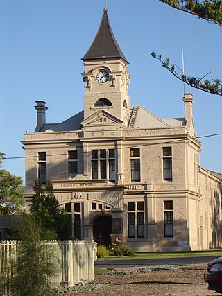
Moonta is a town on the Yorke Peninsula of South Australia, 165 km (103 mi) north-northwest of the state capital of Adelaide. It is one of three towns known as the Copper Coast or "Little Cornwall" for their shared copper mining history.

Marion Bay is a small township in the Australian state of South Australia at the southern tip of the Yorke Peninsula.

Cowell is a coastal town on Franklin Harbor on the eastern side of the Eyre Peninsula, in South Australia on the Lincoln Highway 111 km south of the major town of Whyalla. It is 493 km by road from Adelaide.
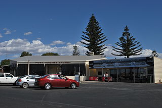
Port Hughes is a town and locality in the Australian state of South Australia located on northern Yorke Peninsula about 135 kilometres (84 mi) north-west of the state capital of Adelaide. It is considered part of the Moonta urban area by the Australian Bureau of Statistics. At the 2016 census, Port Hughes had a population of 571.

Wool Bay is a locality and a former government town in the Australian state of South Australia on the east coast of southern Yorke Peninsula. It is located between Stansbury and Coobowie on Yorke Peninsula, approximately 220 kilometres from Adelaide by road, but only just over 60 km due west across Gulf St Vincent.
Balgowan is a small coastal town on the west coast of South Australia's Yorke Peninsula. It is located approximately 20 kilometres west of Maitland. Like other towns popular with tourists on Yorke Peninsula, it has a large number of shacks, holiday houses, caravan facilities and a boat ramp. The population generally increases during peak holiday periods.

Copper Coast is a region of South Australia situated in Northern Yorke Peninsula and comprising the towns of Wallaroo, Kadina, Moonta, Paskeville and Port Hughes. The area approximately bounded by Wallaroo, Kadina and Moonta is also known as the Copper Triangle. The area is so named because copper was mined from there in the late 19th and early 20th centuries, a significant source of economic prosperity for South Australia at the time. These three towns are known for their large Cornish ethnicity, often called "Little Cornwall". Kernewek Lowender is the world's largest Cornish Festival, held biennially in the Cornish Triangle. The area continues to make a significant contribution to the economy of South Australia, as a major producer of grain, particularly barley and wheat.

The Copper Coast Council is a local government area in the Australian state of South Australia located at the northern end of the Yorke Peninsula. It was established in 1997 and its seat is in Kadina.

Point Turton is a coastal town 114 kilometres (71 mi) west of Adelaide, South Australia. It is located in the Yorke Peninsula Council.

Clinton is a locality in the Australian state of South Australia located on the east coast of Yorke Peninsula overlooking the north west head of Gulf St Vincent about 101 kilometres (63 mi) west of the state capital of Adelaide and about 36 kilometres (22 mi) north-east of the municipal seat of Maitland.

Port Arthur is a locality in the Australian state of South Australia located on the Yorke Peninsula at the northern end of Gulf St Vincent about 105 kilometres north west of the state capital of Adelaide and about 9 kilometres north of the town of Port Wakefield.
Warburto is a locality in South Australia located on the west coast of Yorke Peninsula, consisting of the rural areas south of the town of Wallaroo around the headland of Warburto Point. It immediately adjoins Spencer Gulf, and is located about 140 kilometres north-west of the Adelaide city centre.
East Moonta is a rural locality at the northern end of the Yorke Peninsula and a satellite village to the town of Moonta. It is located in the Copper Coast Council.
Hamley is a locality in the Australian state of South Australia located on the Yorke Peninsula on the southern side of the urban area associated with Moonta about 130 kilometres north-west of the Adelaide city centre.
North Moonta is a locality in the Australian state of South Australia located at the northern end of the Yorke Peninsula on the north side of the town of Moonta.
Paramatta is a locality in the Australian state of South Australia located on the Yorke Peninsula on the north-east side of the urban area associated with Moonta about 132 kilometres north-west of the Adelaide city centre. It was named using the same Aboriginal phrase for the suburb of Sydney spelled Parramatta.


