Jerusalem, South Australia

Last updated

Jerusalem
South Australia
Australia South Australia location map.svg
Red pog.svg
Jerusalem
Coordinates 33°58′47″S137°42′39″E / 33.979630°S 137.710830°E / -33.979630; 137.710830
Population424 (SAL 2021) [1]
Postcode(s) 5554 [2]
LGA(s) Copper Coast Council
State electorate(s) Narungga [3]
Federal division(s) Grey [2]
Localities around Jerusalem:
Matta Flat Kadina Kadina
Matta Flat Jerusalem Kadina
Kadina Kadina Kadina
FootnotesCoordinates [4]

Jerusalem (originally New Jerusalem) is a suburb of the town of Kadina on the Yorke Peninsula. It is located in the Copper Coast Council. [2] The boundaries were formally gazetted in January, 1999, although the name had long been in use for the area. [4]

History

It was surveyed in 1871 as a result of demand for housing from those involved in the nearby Wallaroo Mines, forming one of four "occupation blocks" in the area. [5] An old resident claimed that the suburb was intended for "gentleman's residences" as opposed to the other occupation blocks, and that a "Councillor Rosenberg" had suggested Jerusalem as a name for an "aristocratic suburb". [6] In 1874, the local newspaper stated that "the name is not considered suitable to the place, and generally strikes the ear of a stranger as somewhat ridiculous", while the local Bible Christian minister stated that "dog-fighting, wombat and wallaby-hunting were the regular Sunday exercises, and sin had stamped its wretched impress upon the whole neighbourhood." [7] [8]

A Bible Christian chapel opened at Jerusalem in February 1874. [8] The main Jerusalem football team merged with the Kadina club in 1908, [9] and the "Jews" football and cricket teams were later based at Jerusalem in the 1920s, competing in the local Kadina competitions. [10] [11] The Jerusalem Methodist Church opened in January 1922, built by voluntary labour on a block of land donated by the Wallaroo and Kadina Mining Company. [12] [13] The Jerusalem Sunday School began in March of the same year. [14] Prior to the church's opening, the Wallaroo Mines Gospel Mission Band had been holding open-air and cottage meetings at Jerusalem for three years. [15] It remains in operation as the Jerusalem Uniting Church. [16]

Related Research Articles

<span class="mw-page-title-main">Wallaroo, South Australia</span> Town in South Australia

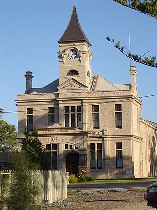
Wallaroo is a port town on the western side of Yorke Peninsula in South Australia, 160 kilometres (100 mi) northwest of Adelaide. It is one of the three Copper Triangle towns famed for their historic shared copper mining industry, and known together as "Little Cornwall", the other two being Kadina, about 8 kilometres (5 mi) to the east, and Moonta, about 18 kilometres (11 mi) south. In 2016, Wallaroo had a population of 3,988 according to the census held.

<span class="mw-page-title-main">Kadina, South Australia</span> Town in South Australia

Kadina is a town on the Yorke Peninsula of the Australian state of South Australia, approximately 144 kilometres north-northwest of the state capital of Adelaide. The largest town of the Peninsula, Kadina is one of the three Copper Triangle towns famous for their shared copper mining history. The three towns are known as "Little Cornwall" for the significant number of immigrants from Cornwall who worked at the mines in the late 19th century.

<span class="mw-page-title-main">Moonta, South Australia</span> Town in South Australia

Moonta is a town on the Yorke Peninsula of South Australia, 165 km (103 mi) north-northwest of the state capital of Adelaide. It is one of three towns known as the Copper Coast or "Little Cornwall" for their shared copper mining history.

<span class="mw-page-title-main">Paskeville, South Australia</span> Town in South Australia

Paskeville is a town on South Australia's Yorke Peninsula. It is located approximately 20 km east of Kadina on the Copper Coast Highway towards Adelaide. At the 2016 census, Paskeville had a population of 178. The town's district is administratively divided between the Copper Coast Council and the District Council of Barunga West.

<span class="mw-page-title-main">Copper Coast Council</span> Local government area in South Australia

The Copper Coast Council is a local government area in the Australian state of South Australia located at the northern end of the Yorke Peninsula. It was established in 1997 and its seat is in Kadina.

<span class="mw-page-title-main">Wallaroo Mines, South Australia</span> Suburb of Kadina, South Australia

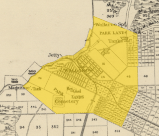
Wallaroo Mines is a suburb of the inland town of Kadina on the Yorke Peninsula in the Copper Coast Council area. It was named for the land division in which it was established in 1860, the Hundred of Wallaroo, as was the nearby coastal town of Wallaroo. The boundaries were formally gazetted in January 1999 for "the long established name".

Jericho is a suburb of the town of Kadina on the Yorke Peninsula. It is located in the Copper Coast Council. The boundaries were formally gazetted in January 1999, although the name had long been in use for the area. It was surveyed in 1871 as one of four "occupation blocks" to meet high demand for housing near Wallaroo Mines.

Matta Flat is a suburb of the town of Kadina on the Yorke Peninsula. It is located in the Copper Coast Council. The boundaries were formally gazetted in January 1999, although the name had long been in use for the area.

Ninnes is a locality at the northeastern corner of Yorke Peninsula and western side of the Mid North of South Australia. It lies where the Upper Yorke Road from Kulpara to Bute is crossed by the road from Paskeville to Lochiel. The dominant industry is broadacre grain and sheep farming.

New Town is a suburb of the town of Kadina on the Yorke Peninsula. It is located in the Copper Coast Council. The boundaries were formally gazetted in January 1999, although the name had long been in use for the area.

<span class="mw-page-title-main">Cross Roads, South Australia</span> Town in South Australia

Cross Roads is a locality at the northern end of the Yorke Peninsula and a satellite village to the town of Moonta on its east. It is located in the Copper Coast Council.

<span class="mw-page-title-main">Balaklava-Moonta railway line</span> Former railway line in South Australia

The Balaklava-Moonta railway line was a railway line on the South Australian Railways network. It ran across the top of the Yorke Peninsula.

The District Council of Bute was a local government area in South Australia from 1885 to 1997.

Boors Plain is a rural locality at the north end of the Yorke Peninsula of South Australia, situated east of Moonta and south of Kadina. It is located in the Copper Coast Council.

<span class="mw-page-title-main">Corporate Town of Wallaroo</span>

The Corporate Town of Wallaroo was a local government area in South Australia from 1874 to 1997, centred on the town of Wallaroo.

The District Council of Kadina was a local government area in South Australia from 1888 to 1984.

Hancock's Billiard Saloon is a heritage-listed former billiard saloon and barber shop at 36-38 Taylor Street, Kadina, South Australia. It is also known as Hancock's Barber Shop and Humphries Barber Shop. It was listed on the South Australian Heritage Register on 28 May 1987 and on the former Register of the National Estate on 1 November 1983.

Kadina Cemetery is a heritage-listed cemetery in Drain Road, Kadina, South Australia. It was listed on the South Australian Heritage Register on 28 November 1985 and on the former Register of the National Estate on 1 November 1983. It is managed by the District Council of the Copper Coast.

The Plain Dealer was a weekly Saturday newspaper in Kadina, South Australia, operating from 1894 until 1926 as a smaller competitor to the Kadina and Wallaroo Times.

<span class="mw-page-title-main">Hundred of Wallaroo</span> Cadastral in South Australia

The Hundred of Wallaroo is a cadastral unit of hundred located on the Copper Coast of South Australia. It is one of the 16 hundreds of the County of Daly. It was named in 1862 by Governor Dominick Daly after the indigenous term wadla warru presumed to mean wallaby urine.

References

  1. Australian Bureau of Statistics (28 June 2022). "Jerusalem (Suburb and Locality)". Australian Census 2021 QuickStats. Retrieved 28 June 2022.  OOjs UI icon edit-ltr-progressive.svg
  2. 1 2 3 "Search result(s) for Jerusalem, 5554". Location SA Map Viewer. Government of South Australia. Retrieved 21 January 2017.
  3. Narungga (Map). Electoral District Boundaries Commission. 2016. Retrieved 1 March 2018.
  4. 1 2 "Search result(s) for Jerusalem, 5554". Property Location Browser. Government of South Australia. Archived from the original on 12 October 2016. Retrieved 26 November 2016.
  5. Drew, Greg (1990). Discovering Historic Kadina, South Australia. Department of Mines and Energy and the District Council of Northern Yorke Peninsula. p. 15.
  6. Bailey, Keith (1990). Copper City Chronicle: A History of Kadina. p. 166.
  7. Payton, Philip (2007). Making Moonta: The Invention of Australia's Little Cornwall. University of Exeter Press. p. 158.
  8. 1 2 "The Wallaroo Times". The Wallaroo Times and Mining Journal . Vol. X, no. 926. South Australia. 21 February 1874. p. 2. Retrieved 21 January 2017 via National Library of Australia.
  9. Bailey, Keith (1990). Copper City Chronicle: A History of Kadina. p. 163.
  10. "JERUSALEM NEWS". The Kadina And Wallaroo Times . Vol. LVII, no. 6072. South Australia. 29 August 1923. p. 3. Retrieved 21 January 2017 via National Library of Australia.
  11. "JERUSALEM ITEMS". The Kadina And Wallaroo Times . Vol. LIX, no. 6859. South Australia. 24 October 1925. p. 2. Retrieved 21 January 2017 via National Library of Australia.
  12. "JERUSALEM METHODIST CHURCH". The Kadina And Wallaroo Times . Vol. LVI, no. 5899. South Australia. 1 February 1922. p. 2. Retrieved 21 January 2017 via National Library of Australia.
  13. "NEW CHURCH AT JERUSALEM". The Kadina And Wallaroo Times . Vol. LVI, no. 5897. South Australia. 25 January 1922. p. 2. Retrieved 21 January 2017 via National Library of Australia.
  14. "GENERAL NEWS". The Kadina And Wallaroo Times . Vol. LVII, no. 6023. South Australia. 10 March 1923. p. 2. Retrieved 21 January 2017 via National Library of Australia.
  15. "KADINA AND DISTRICT CHURCHES". The Kadina And Wallaroo Times . Vol. LXV, no. 7405. South Australia. 2 May 1931. p. 3. Retrieved 21 January 2017 via National Library of Australia.
  16. "Jerusalem Uniting Church (Kadina)". Uniting Church of Australia. Retrieved 21 January 2017.