Moonta Mines, South Australia

Last updated

Moonta Mines
South Australia
Map of Moonta Mines pre-1923 (SA Dept of Mines and Energy).tif
Map of Moonta Mines pre-1923 (click to enlarge)
Australia South Australia location map.svg
Red pog.svg
Moonta Mines
Coordinates 34°04′33″S137°36′04″E / 34.075810°S 137.601150°E / -34.075810; 137.601150 Coordinates: 34°04′33″S137°36′04″E / 34.075810°S 137.601150°E / -34.075810; 137.601150
Population177 (SAL 2021) [1]
Postcode(s) 5558 [2]
LGA(s) Copper Coast Council
State electorate(s) Goyder [2]
Federal division(s) Grey [2]
Localities around Moonta Mines:
Moonta Moonta Yelta
Kooroona
Hamley
Moonta Mines East Moonta
Nalyappa Agery Agery
FootnotesCoordinates [3]

Moonta Mines is a locality at the northern end of the Yorke Peninsula, adjoining the town of Moonta. It is located in the Copper Coast Council. [2] From 1861 to 1923, it was the centre of a copper mining industry that formed colonial South Australia's largest mining enterprise. [4] [5] A substantial portion of the locality is listed on the South Australian Heritage Register as the Moonta Mines State Heritage Area and on the National Heritage List as the Australian Cornish Mining Heritage Site, Moonta Mines. [4] [6]

Contents

History

Hughes's enginehouse, similar to Richman's enginehouse in the photo below below Moonta Mines Hughes' Enginehouse 4 (22049325459).jpg
Hughes's enginehouse, similar to Richman's enginehouse in the photo below below
Richman's Plant during the 1890s - copper ore processing plant, workers and two steam locomotives. Behind the timber buildings is the enginehouse, the shell of which remains at the site; the beam engine protrudes on its right, just below the overhanging gangway. Richman's Plant at Moonta Mines -- Beyer, Peacock 0-4-0WT no 3057 and Hudswell Clarke 0-4-2ST no 394 c1890s (SRSA).jpg
Richman's Plant during the 1890s – copper ore processing plant, workers and two steam locomotives. Behind the timber buildings is the enginehouse, the shell of which remains at the site; the beam engine protrudes on its right, just below the overhanging gangway.

Patrick " Paddy " Ryan, a shepherd for pastoralist Sir Walter Hughes, discovered copper on Hughes' property at Moonta in May 1861. The Tiparra Mining Association (later the Moonta Mining Company) commenced operations in 1862 after a legal battle over title to the claim. [7] It proved extremely successful, with the Moonta deposits resulting in high yields. It saw a particular influx of miners from Cornwall in England. The government town of Moonta was surveyed in 1863, which resulted in a division between the professional classes in Moonta and a more informal township dominated by mining workers at Moonta Mines. The Moonta miners' undertook a major strike in 1864 over concerns about mining practices. [8] [9] [10]

By 1875, the success of the Moonta Mines and those in the surrounding area had made Moonta the second largest town in South Australia and the largest copper region in the British Empire; Moonta Mines itself had a population of 5,000 residents. In 1876, the Moonta Mining Company became the first mining company in Australia to pay out one million pounds in dividends. However, living conditions were poor and many people died to disease during this time. Copper prices had begun to decline by the 1880s, and in 1889 forced the Moonta Mining Company to merge with the owners of Wallaroo Mines to form the Wallaroo and Moonta Mining and Smelting Co. Ltd. The mine finally closed in 1923, after which the Moonta Mines locality sharply declined, although the cementation works continued in use until 1943. The Moonta Mines State Heritage Area was declared in 1984. [8] [9] [10] The modern locality of Moonta Mines was established in January 1999, when boundaries were formalised for the long established name. [11]

Industrial railway

A narrow gauge steam locomotive was used at the Moonta Mines on the 2 ft 9 in (838 mm) gauge line between Taylor's Shaft and Richman's Plant. Built in 1889 in Manchester, England by Beyer, Peacock & Company it was works number 3057 and was later converted to 3 ft 6 in (1,067 mm) gauge for operation on the mines' railway system. It was sold about 1911 to Henry & Sons, sawmillers of Forrest, Victoria via Cameron & Sutherland, Melbourne dealers. [12]

Moonta Mines today

Moonta Mines Museum (formerly Moonta Mines Model School, 1878-1968) Moonta Mines Museum (former Moonta Mines School) at Moonta, South Australia.jpg
Moonta Mines Museum (formerly Moonta Mines Model School, 1878–1968)

The National Trust of South Australia has a substantial presence at Moonta Mines, operating seven properties as tourist attractions through its Moonta branch. [13] These include the National Trust Museum in the former Moonta Mines Model School (1878-1968), the Moonta Mines Tourist Railway offering 50-minute guided tours of the former mining works, the Moonta Mines Sweet Shop in the former Moonta Mines Post Office building (1946-1970s), a former miners' cottage and garden in Verco Street, the Hughes Enginehouse (1865-1923), Richmans Enginehouse (1869-1923) and the Family History and Resource Centre in the former School of Mines. [14] [15]

The historic Moonta Mines Uniting Church, which dates from 1865 when it opened as the Wesleyan Methodist church, remains in operation with weekly services. It also has open days during the week or on weekends, depending upon the time of year. [16]

Heritage listings

Moonta Mines contains a number of individually heritage-listed sites, including:

Notes

  1. The locomotives are Beyer, Peacock 0-4-0 WT (Works Number 3057) (foreground) and Hudswell Clarke 0-4-2 ST (Works Number 394).

Related Research Articles

<span class="mw-page-title-main">Quorn, South Australia</span> Town in South Australia

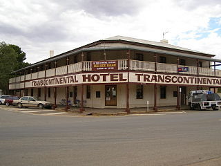
Quorn is a small town and railhead in the Flinders Ranges in the north of South Australia, 39 kilometres (24 mi) northeast of Port Augusta. At the 2016 census, the locality had a population of 1,230, of which 1,131 lived in its town centre.

<span class="mw-page-title-main">Wallaroo, South Australia</span> Town in South Australia

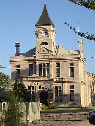
Wallaroo is a port town on the western side of Yorke Peninsula in South Australia, 160 kilometres (100 mi) northwest of Adelaide. It is one of the three Copper Triangle towns famed for their historic shared copper mining industry, and known together as "Little Cornwall", the other two being Kadina, about 8 kilometres (5 mi) to the east, and Moonta, about 18 kilometres (11 mi) south. In 2016, Wallaroo had a population of 3,988 according to the census held.

<span class="mw-page-title-main">Truro, South Australia</span> Town in South Australia

Truro is a town in South Australia, 80 km northeast of Adelaide. It is situated in an agricultural and pastoral district on the Sturt Highway, east of the Barossa Valley, where the highway crosses somewhat lofty and rugged parts of the Mount Lofty Ranges. At the 2021 census, Truro had a population of 523.

<span class="mw-page-title-main">Blinman</span> Town in South Australia

Blinman is a locality incorporating two towns located in the Australian state of South Australia within the Flinders Ranges about 425 kilometres (264 mi) north of the state capital of Adelaide. It is very small but has the claim of being the highest surveyed town in South Australia. It serves as a base for large acre pastoralists and tourism. The town is just north of the Flinders Ranges National Park, is 60 kilometres north of Wilpena Pound.

<span class="mw-page-title-main">Kadina, South Australia</span> Town in South Australia

Kadina is a town on the Yorke Peninsula of the Australian state of South Australia, approximately 144 kilometres north-northwest of the state capital of Adelaide. The largest town of the Peninsula, Kadina is one of the three Copper Triangle towns famous for their shared copper mining history. The three towns are known as "Little Cornwall" for the significant number of immigrants from Cornwall who worked at the mines in the late 19th century.

<span class="mw-page-title-main">Moonta, South Australia</span> Town in South Australia

Moonta is a town on the Yorke Peninsula of South Australia, 165 km (103 mi) north-northwest of the state capital of Adelaide. It is one of three towns known as the Copper Coast or "Little Cornwall" for their shared copper mining history.

<span class="mw-page-title-main">Copper Coast</span> Region of South Australia

Copper Coast is a region of South Australia situated in Northern Yorke Peninsula and comprising the towns of Wallaroo, Kadina, Moonta, Paskeville and Port Hughes. The area approximately bounded by Wallaroo, Kadina and Moonta is also known as the Copper Triangle. The area is so named because copper was mined from there in the late 19th and early 20th centuries, a significant source of economic prosperity for South Australia at the time. These three towns are known for their large Cornish ethnicity, often called "Little Cornwall". Kernewek Lowender is the world's largest Cornish Festival, held biennially in the Cornish Triangle. The area continues to make a significant contribution to the economy of South Australia, as a major producer of grain, particularly barley and wheat.

<span class="mw-page-title-main">Moonta Bay, South Australia</span> Town in South Australia

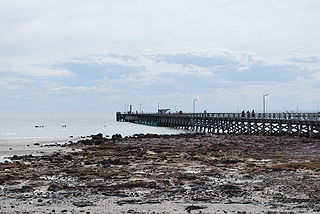
Moonta Bay is located in the Copper Coast region of Northern Yorke Peninsula South Australia, adjacent to the historic town of Moonta and Port Hughes.

<span class="mw-page-title-main">Wallaroo Mines, South Australia</span> Suburb of Kadina, South Australia

Wallaroo Mines is a suburb of the inland town of Kadina on the Yorke Peninsula in the Copper Coast Council area. It was named for the land division in which it was established in 1860, the Hundred of Wallaroo, as was the nearby coastal town of Wallaroo. The boundaries were formally gazetted in January 1999 for "the long established name".

Matta Flat is a suburb of the town of Kadina on the Yorke Peninsula. It is located in the Copper Coast Council. The boundaries were formally gazetted in January 1999, although the name had long been in use for the area.

<span class="mw-page-title-main">Cross Roads, South Australia</span> Town in South Australia

Cross Roads is a locality at the northern end of the Yorke Peninsula and a satellite village to the town of Moonta on its east. It is located in the Copper Coast Council.

East Moonta is a rural locality at the northern end of the Yorke Peninsula and a satellite village to the town of Moonta. It is located in the Copper Coast Council.

Hamley is a locality in the Australian state of South Australia located on the Yorke Peninsula on the southern side of the urban area associated with Moonta about 130 kilometres north-west of the Adelaide city centre.

Kooroona is a rural locality at the north end of the Yorke Peninsula of South Australia, situated directly south of the town of Moonta. It is located in the Copper Coast Council.

North Yelta is a rural locality in the Australian state of South Australia at the northern end of the Yorke Peninsula.

Yelta is a rural locality at the northern end of the Yorke Peninsula and a satellite village to the town of Moonta, centred on the former Yelta Mine. It is located in the Copper Coast Council. The modern locality was established when the name and boundaries were selected in January 1999.

Boors Plain is a rural locality at the north end of the Yorke Peninsula of South Australia, situated east of Moonta and south of Kadina. It is located in the Copper Coast Council.

<span class="mw-page-title-main">Flinders Ranges, South Australia</span> Suburb of Flinders Ranges Council, South Australia

Flinders Ranges is a locality in the Australian state of South Australia located in the mountain range of the same name, about 380 km (240 mi) north of the state capital of Adelaide, about 86 km (53 mi) north-east of the municipal seat in Quorn and about 131 km (81 mi) north-east of the regional centre of Port Augusta.

The Australian Cornish Mining Sites are historic sites in South Australia listed jointly on the Australian National Heritage List. There are two distinct sites – Burra in the mid-north of the state and Moonta Mines in the northern Yorke Peninsula region. The heritage value of both sites relates to their history as mines worked by migrant miners from Cornwall. The sites were inscribed on the Australian National Heritage List on 9 May 2017.

References

  1. Australian Bureau of Statistics (28 June 2022). "Moonta Mines (Suburb and Locality)". Australian Census 2021 QuickStats. Retrieved 28 June 2022.  OOjs UI icon edit-ltr-progressive.svg
  2. 1 2 3 4 "Search result(s) for Moonta Mines, 5558". Location SA Map Viewer. Government of South Australia. Retrieved 18 May 2016.
  3. "Search result for "Moonta Mines (Locality Bounded)" (Record no SA0046045)". Property Location Browser. Government of South Australia. Archived from the original on 12 October 2016. Retrieved 30 May 2016.
  4. 1 2 "Moonta Mines State Heritage Area". South Australian Heritage Register. Department of Environment, Water and Natural Resources. Retrieved 19 May 2016.
  5. "Moonta Mines State Heritage Area". Department of Environment, Water and Natural Resources. Retrieved 19 May 2016.
  6. "Australian Cornish Mining Heritage Sites, Barrier Hwy, Burra, SA, Australia". National Heritage List. Department of the Environment. Retrieved 19 May 2016.
  7. "Moonta Mines". Copper Coast Council. Retrieved 26 July 2017.
  8. 1 2 "The Moonta Mine". Flinders Ranges Research. Retrieved 19 May 2016.
  9. 1 2 "State Heritage Area Guidelines for Development" (PDF). Department of Environment, Water and Natural Resources. Retrieved 19 May 2016.
  10. 1 2 "Mining in Australia". Adelaide Resources. Retrieved 19 May 2016.
  11. "Search result(s) for Moonta Mines, 5558". Property Location Browser. Government of South Australia. Archived from the original on 12 October 2016. Retrieved 19 May 2016.
  12. Steam locomotive at Moonta mines. State Library of South Australia B 36083.
  13. "Branches SA". National Trust of Australia. Retrieved 12 January 2018.
  14. "Attractions". National Trust of Australia, Moonta Branch. Retrieved 19 May 2016.
  15. "Moonta Mines Tourist Train". Moonta and District Progress Association. Retrieved 19 May 2016.
  16. "Moonta Mines Uniting Church". Uniting Church of Australia. Retrieved 19 May 2016.
  17. "Moonta Mines Uniting (former Wesleyan Methodist) Church, including Fence and Sunday School Building". South Australian Heritage Register. Department of Environment, Water and Natural Resources. Retrieved 19 May 2016.
  18. "Moonta Mines Model Sunday School Site". South Australian Heritage Register. Department of Environment, Water and Natural Resources. Retrieved 19 May 2016.
  19. "Miner's Cottage & Fence". South Australian Heritage Register. Department of Environment, Water and Natural Resources. Retrieved 19 May 2016.
  20. "National Trust Museum (former Moonta Mines Model School)". South Australian Heritage Register. Department of Environment, Water and Natural Resources. Retrieved 19 May 2016.
  21. "Former Hughes Pump House & Chimney". South Australian Heritage Register. Department of Environment, Water and Natural Resources. Retrieved 19 May 2016.