
Kadina is a town on the Yorke Peninsula of the Australian state of South Australia, approximately 144 kilometres north-northwest of the state capital of Adelaide. The largest town of the Peninsula, Kadina is one of the three Copper Triangle towns famous for their shared copper mining history. The three towns are known as "Little Cornwall" for the significant number of immigrants from Cornwall who worked at the mines in the late 19th century.

Moonta is a town on the Yorke Peninsula of South Australia, 165 km (103 mi) north-northwest of the state capital of Adelaide. It is one of three towns known as the Copper Coast or "Little Cornwall" for their shared copper mining history.
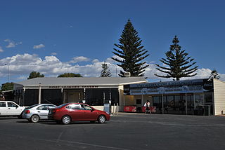
Port Hughes is a town and locality in the Australian state of South Australia located on northern Yorke Peninsula about 135 kilometres (84 mi) north-west of the state capital of Adelaide. It is considered part of the Moonta urban area by the Australian Bureau of Statistics. At the 2016 census, Port Hughes had a population of 571.

The Copper Coast Council is a local government area in the Australian state of South Australia located at the northern end of the Yorke Peninsula. It was established in 1997 and its seat is in Kadina.

Coobowie is a town in the Australian state of South Australia near the south-eastern tip of Yorke Peninsula. Coobowie was proclaimed in 1875. Coobowie comes from an Aboriginal word meaning "wild fowl water". At the 2011 census, Coobowie shared a population of 220 with other localities. Coobowie's current outlook is to create many new features including making improvements to the foreshore play area.

Weetulta is a locality in the Australian state of South Australia located on the Yorke Peninsula. The locality is in the Yorke Peninsula Council local government area, 162 kilometres (101 mi) west of the state capital, Adelaide.
Jerusalem is a suburb of the town of Kadina on the Yorke Peninsula. It is located in the Copper Coast Council. The boundaries were formally gazetted in January, 1999, although the name had long been in use for the area.

Wallaroo Mines is a suburb of the inland town of Kadina on the Yorke Peninsula in the Copper Coast Council area. It was named for the land division in which it was established in 1860, the Hundred of Wallaroo, as was the nearby coastal town of Wallaroo. The boundaries were formally gazetted in January 1999 for "the long established name".
Matta Flat is a suburb of the town of Kadina on the Yorke Peninsula. It is located in the Copper Coast Council. The boundaries were formally gazetted in January 1999, although the name had long been in use for the area.
Winulta was a town in the Australian state of South Australia on northern Yorke Peninsula around 10 km from Clinton on the Clinton-Maitland road. It was first settled for farming around 1876. The earliest farmers were William Short, Thomas Kenny and John Sharrad.
New Town is a suburb of the town of Kadina on the Yorke Peninsula. It is located in the Copper Coast Council. The boundaries were formally gazetted in January 1999, although the name had long been in use for the area.

Cross Roads is a locality at the northern end of the Yorke Peninsula and a satellite village to the town of Moonta on its east. It is located in the Copper Coast Council.
East Moonta is a rural locality at the northern end of the Yorke Peninsula and a satellite village to the town of Moonta. It is located in the Copper Coast Council.
Hamley is a locality in the Australian state of South Australia located on the Yorke Peninsula on the southern side of the urban area associated with Moonta about 130 kilometres north-west of the Adelaide city centre.
Kooroona is a rural locality at the north end of the Yorke Peninsula of South Australia, situated directly south of the town of Moonta. It is located in the Copper Coast Council.
North Yelta is a rural locality in the Australian state of South Australia at the northern end of the Yorke Peninsula.
Paramatta is a locality in the Australian state of South Australia located on the Yorke Peninsula on the north-east side of the urban area associated with Moonta about 132 kilometres north-west of the Adelaide city centre. It was named using the same Aboriginal phrase for the suburb of Sydney spelled Parramatta.
Yelta is a rural locality at the northern end of the Yorke Peninsula and a satellite village to the town of Moonta, centred on the former Yelta Mine. It is located in the Copper Coast Council. The modern locality was established when the name and boundaries were selected in January 1999.
Boors Plain is a rural locality at the north end of the Yorke Peninsula of South Australia, situated east of Moonta and south of Kadina. It is located in the Copper Coast Council.
Koolywurtie is a locality in the Australian state of South Australia located on the Yorke Peninsula about 93 kilometres (58 mi) west of the state capital of Adelaide and about 20 kilometres (12 mi) south of the municipal seat of Maitland.
