Wallaroo Mines, South Australia

Last updated

Wallaroo Mines
Kadina,  South Australia
Wallaroo mines, Kadina (17).JPG
Harvey's Pumping Station
Australia South Australia location map.svg
Red pog.svg
Wallaroo Mines
Coordinates 33°57′58″S137°41′53″E / 33.966202°S 137.698080°E / -33.966202; 137.698080
Population408 (SAL 2021) [1]
Established1860 [2]
Postcode(s) 5554 [3]
LGA(s) Copper Coast Council
State electorate(s) Narungga [4]
Federal division(s) Grey [3]
Suburbs around Wallaroo Mines:
Matta Flat New Town Kadina
Jericho Wallaroo Mines Matta Flat
Kadina Kadina Kadina
FootnotesCoordinates [5]

Wallaroo Mines is a suburb of the inland town of Kadina on the Yorke Peninsula in the Copper Coast Council area. [3] It was named for the land division in which it was established in 1860, the Hundred of Wallaroo, as was the nearby coastal town of Wallaroo. The boundaries were formally gazetted in January 1999 for "the long established name". [5]

Contents

History

With the arrival of British pioneers in the late 1830s and 1840s, pastoralists began grazing livestock in the vicinity but no permanent settlements were formed.

Development

On 17 December 1859, James Boor, a shepherd on the Wallaroo sheep run, owned by Walter Watson Hughes, discovered copper at what was to become Wallaroo Mines. Thirty or forty men were reportedly working at the site by the end of the year. By August 1860, the new copper mines employed 150 men and were "turning out ores of a rich quality", and by the end of 1860 there was a total population of 500. The mines had an enginehouse, office, a residence for the captain and secretary, and an assay office by this point, along with its own store for the miners. The growth of the mines saw the town of Kadina surveyed in 1860, with the first blocks being put up for sale in March 1861. [6] The proprietors formed the business into a private company, the Wallaroo Mining Company, with the first board meeting in August 1860 and Edward Stirling the first chairman. [7]

A settlement developed around the mine in 1860, described as "a collection of miners' cottages, sheds, mine shafts, enginehouses and other mine buildings". [2] A Primitive Methodist chapel was built in 1861. [8] A canvas structure that had served as a courthouse was moved from the mines to the present courthouse site in Kadina on 2 April 1861, with the "gipsy tent" police station following in January 1862. Lay Methodist services began at the mines in 1861, before a church was opened in Kadina in November 1862. In June 1862, the Kadina and Wallaroo Railway and Pier Company opened a horse-driven railway connecting the mines to the port at Wallaroo, with a branch into Kadina. It was subsequently bought out by the South Australian government on 1 March 1878, with the steam railway from Adelaide arriving in the same year; the old horse-driven line was later pulled up. [9] A Bible Christian church was built in 1866, and the Wallaroo Mines Wesleyan Methodist Church was built in 1867. [10]

Peak

The mine reached its peak between 1870 and 1875, when it had up to 1000 employees. [7] Wallaroo Mines Primary School opened on 31 January 1878 as the first public school in the Kadina area. [11] [12] The mine temporarily closed from August 1878 until 1880 due to low copper prices, resulting in a large exodus from the district. It remained in restricted operations through much of the 1880s. [13] [14] Wallaroo Mines Post Office opened on 1 July 1890. [15]

Wallaroo Mines miners in 1900 Wallaroo miners 1900.jpg
Wallaroo Mines miners in 1900

In 1889–90, the Wallaroo and Moonta Mines merged to form the Wallaroo and Moonta Mining and Smelting Company, becoming the largest industrial operation in South Australia. [7] Prior to their amalgamation, the Wallaroo Mine had produced 491,934 tonnes of copper, valued at £2,229,096, with dividends of £430,254. The production of the Wallaroo Mine outpaced that of the Moonta Mines in 1899. [16] 1n 1900, there was an outbreak of typhoid at Wallaroo Mines, and after a new doctor described the town's sanitary conditions as "disgusting and barbarous", the mining company undertook several improvements and mains water was introduced. [17] The Wallaroo Mines Institute was built by the mining company in 1902. [8] In 1904, a fire in Taylor's Shaft, then the main point of operations, lasted for over a month and cost £50,000, resulting in a "modernisation program" for the mine. The employment of the mine peaked in 1906 at a total of 2700 employees. [7]

Closure

The mines struggled in the years after World War I due to a downturn in the price of copper, closing for long periods and losing large amounts of money between 1919 and 1922. In November 1923, the mining company went into voluntary liquidation and the mine shut down. [18] The total production throughout its lifetime was about 165,000 tonnes with a value of £9.7 million. [19] The closure had a flow-on effect to the broader Kadina area, with an exodus from the region large enough to result in the closure of several churches and other facilities there. [20]

The Elders Engine House was demolished, with its stone being used several years later, in 1936, to build the new Kadina Catholic Church. The Primitive Methodist church was demolished in 1927. [21] The former Bible Christian church was demolished in the late 1930s; while it had closed as a church some decades before, it had later been used as a community hall and cinema. [10] Wallaroo Mines had a football club in the Yorke Peninsula Football Association as the "Federal Rovers"; however, the league went into recess in 1936. [22] A small store existed on Lipson Road for many years, run by Will Harwood from 1920. The original school building closed around 1967 and was demolished in 1977. Wallaroo Mines Post Office closed on 30 April 1976. [15] The Wallaroo Mines Methodist Church building was demolished in 1980, and the church subsequently moved into the Wallaroo Mines Institute. [8] An ore-processing plant was built on the former site of the school in 1988 by Moonta Mining NL, treating ore from their Poona mine 5 km north of Moonta; however, the Poona mine had closed by 1992. [23] [24]

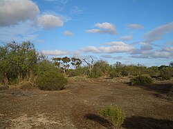
Wallaroo Mines today

On the grounds of Wallaroo Mines, some areas still hardly have any vegetation other than mosses etc. Wallaroo-mines-0749.jpg
On the grounds of Wallaroo Mines, some areas still hardly have any vegetation other than mosses etc.

There is a self-guided walking trail around the former Wallaroo Mines site. [8] The former Harvey's Pumping Station (also known as Harvey's Enginehouse), dating from 1874, is the last of the former mine pumping stations to survive, and is listed on the South Australian Heritage Register. [25] The Kadina Heritage Trail also notes the site of an 1860 pioneer cemetery, the site of the former Methodist Church, the former police residence, the former post office, the mine explosives magazine, captains' residences, mine manager's residence ruins, the site of the Devon mine, and a number of old residences associated with the Wallaroo Mines settlement. [7] The Wallaroo Mines Primary School remains in operation on a new site to the north of the original location, and had 102 enrolled students in 2015. [26]

See also

Related Research Articles

<span class="mw-page-title-main">Wallaroo, South Australia</span> Town in South Australia

Wallaroo is a port town on the western side of Yorke Peninsula in South Australia, 160 kilometres (100 mi) northwest of Adelaide. It is one of the three Copper Triangle towns famed for their historic shared copper mining industry, and known together as "Little Cornwall", the other two being Kadina, about 8 kilometres (5 mi) to the east, and Moonta, about 18 kilometres (11 mi) south. In 2016, Wallaroo had a population of 3,988 according to the census held.

<span class="mw-page-title-main">Kadina, South Australia</span> Town in South Australia

Kadina is a town on the Yorke Peninsula of the Australian state of South Australia, approximately 144 kilometres north-northwest of the state capital of Adelaide. The largest town of the Peninsula, Kadina is one of the three Copper Triangle towns famous for their shared copper mining history. The three towns are known as "Little Cornwall" for the significant number of immigrants from Cornwall who worked at the mines in the late 19th century.

<span class="mw-page-title-main">Moonta, South Australia</span> Town in South Australia

Moonta is a town on the Yorke Peninsula of South Australia, 165 km (103 mi) north-northwest of the state capital of Adelaide. It is one of three towns known as the Copper Coast or "Little Cornwall" for their shared copper mining history.

<span class="mw-page-title-main">Copper Coast</span> Region of South Australia

Copper Coast is a region of South Australia situated in Northern Yorke Peninsula and comprising the towns of Wallaroo, Kadina, Moonta, Paskeville and Port Hughes. The area approximately bounded by Wallaroo, Kadina and Moonta is also known as the Copper Triangle. The area is so named because copper was mined from there in the late 19th and early 20th centuries, a significant source of economic prosperity for South Australia at the time. These three towns are known for their large Cornish ethnicity, often called "Little Cornwall". Kernewek Lowender is the world's largest Cornish Festival, held biennially in the Cornish Triangle. The area continues to make a significant contribution to the economy of South Australia, as a major producer of grain, particularly barley and wheat.

<span class="mw-page-title-main">Copper Coast Council</span> Local government area in South Australia

The Copper Coast Council is a local government area in the Australian state of South Australia located at the northern end of the Yorke Peninsula. It was established in 1997 and its seat is in Kadina.

Jerusalem is a suburb of the town of Kadina on the Yorke Peninsula. It is located in the Copper Coast Council. The boundaries were formally gazetted in January, 1999, although the name had long been in use for the area.

Jericho is a suburb of the town of Kadina on the Yorke Peninsula. It is located in the Copper Coast Council. The boundaries were formally gazetted in January 1999, although the name had long been in use for the area. It was surveyed in 1871 as one of four "occupation blocks" to meet high demand for housing near Wallaroo Mines.

Matta Flat is a suburb of the town of Kadina on the Yorke Peninsula. It is located in the Copper Coast Council. The boundaries were formally gazetted in January 1999, although the name had long been in use for the area.

<i>Kadina and Wallaroo Times</i>

The Kadina and Wallaroo Times was a newspaper published in Kadina, and also serving the nearby Wallaroo, South Australia from August 1888 to August 1966. In 1968 the paper merged to form the Yorke Peninsula Country Times.

Doora Mine was a copper mine in the Copper Coast region of South Australia, to the south of Kadina. It began to produce copper around the start of 1871.

New Town is a suburb of the town of Kadina on the Yorke Peninsula. It is located in the Copper Coast Council. The boundaries were formally gazetted in January 1999, although the name had long been in use for the area.

<span class="mw-page-title-main">Cross Roads, South Australia</span> Town in South Australia

Cross Roads is a locality at the northern end of the Yorke Peninsula and a satellite village to the town of Moonta on its east. It is located in the Copper Coast Council.

Hamley is a locality in the Australian state of South Australia located on the Yorke Peninsula on the southern side of the urban area associated with Moonta about 130 kilometres north-west of the Adelaide city centre.

<span class="mw-page-title-main">Moonta Mines, South Australia</span> Town in South Australia

Moonta Mines is a locality at the northern end of the Yorke Peninsula, adjoining the town of Moonta. It is located in the Copper Coast Council. From 1861 to 1923, it was the centre of a copper mining industry that formed colonial South Australia's largest mining enterprise. A substantial portion of the locality is listed on the South Australian Heritage Register as the Moonta Mines State Heritage Area and on the National Heritage List as the Australian Cornish Mining Heritage Site, Moonta Mines.

The District Council of Kadina was a local government area in South Australia from 1888 to 1984.

Hancock's Billiard Saloon is a heritage-listed former billiard saloon and barber shop at 36-38 Taylor Street, Kadina, South Australia. It is also known as Hancock's Barber Shop and Humphries Barber Shop. It was listed on the South Australian Heritage Register on 28 May 1987 and on the former Register of the National Estate on 1 November 1983.

Kadina Cemetery is a heritage-listed cemetery in Drain Road, Kadina, South Australia. It was listed on the South Australian Heritage Register on 28 November 1985 and on the former Register of the National Estate on 1 November 1983. It is managed by the District Council of the Copper Coast.

Matta House is a heritage-listed house in Matta Road, Matta Flat, South Australia. It was listed on the South Australian Heritage Register on 24 July 1980 and on the former Register of the National Estate on 21 March 1978.

The Australian Cornish Mining Sites are historic sites in South Australia listed jointly on the Australian National Heritage List. There are two distinct sites – Burra in the mid-north of the state and Moonta Mines in the northern Yorke Peninsula region. The heritage value of both sites relates to their history as mines worked by migrant miners from Cornwall. The sites were inscribed on the Australian National Heritage List on 9 May 2017.

Henry Richard Hancock almost invariably referred to as "Captain Hancock" was a mine superintendent in Moonta and Wallaroo, South Australia. He was noted for his business acumen and the respect with which he was held by both workers and mine owners.

References

  1. Australian Bureau of Statistics (28 June 2022). "Wallaroo Mines (Suburb and Locality)". Australian Census 2021 QuickStats. Retrieved 28 June 2022.  OOjs UI icon edit-ltr-progressive.svg
  2. 1 2 Drew, Greg (1990). Discovering Historic Kadina, South Australia. Department of Mines and Energy and the District Council of Northern Yorke Peninsula. p. 15.
  3. 1 2 3 "Search result(s) for Wallaroo Mines, 5554". Location SA Map Viewer. Government of South Australia. Retrieved 21 January 2017.
  4. Narungga (Map). Electoral District Boundaries Commission. 2016. Retrieved 1 March 2018.
  5. 1 2 "Search result(s) for Wallaroo Mines, 5554". Property Location Browser. Government of South Australia. Retrieved 26 November 2016.
  6. Bailey, Keith (1990). Copper City Chronicle: A History of Kadina. pp. 7–9.
  7. 1 2 3 4 5 Drew, Greg (1990). Discovering Historic Kadina, South Australia. Department of Mines and Energy and the District Council of Northern Yorke Peninsula. p. 4.
  8. 1 2 3 4 Drew, Greg (1990). Discovering Historic Kadina, South Australia. Department of Mines and Energy and the District Council of Northern Yorke Peninsula. pp. 21–22.
  9. Bailey, Keith (1990). Copper City Chronicle: A History of Kadina. pp. 16–18, 21, 49.
  10. 1 2 Bailey, Keith (1990). Copper City Chronicle: A History of Kadina. pp. 153–155.
  11. "MEMORABILIA, 1878". Adelaide Observer . Vol. XXXVI, no. 1944. 4 January 1879. p. 22. Retrieved 28 January 2017 via National Library of Australia.
  12. Bailey, Keith (1990). Copper City Chronicle: A History of Kadina. p. 31.
  13. "Closing of the Wallaroo Mine". Evening Journal . Vol. X, no. 2935. Adelaide. 26 August 1878. p. 3 (Second Edition). Retrieved 28 January 2017 via National Library of Australia.
  14. Bailey, Keith (1990). Copper City Chronicle: A History of Kadina. p. 45.
  15. 1 2 "Wallaroo Mines". Post Office Reference. Premier Postal. Retrieved 28 January 2017.
  16. "IMPORTANCE OF THE WALLAROO MINES". Adelaide Observer . Vol. LXI, no. 3, 251. 23 January 1904. p. 34. Retrieved 28 January 2017 via National Library of Australia.
  17. Bailey, Keith (1990). Copper City Chronicle: A History of Kadina. pp. 87–88.
  18. Bailey, Keith (1990). Copper City Chronicle: A History of Kadina. p. 125.
  19. Drew, Greg (1990). Discovering Historic Kadina, South Australia. Department of Mines and Energy and the District Council of Northern Yorke Peninsula. pp. 9–10.
  20. Bailey, Keith (1990). Copper City Chronicle: A History of Kadina. pp. 21, 45.
  21. Drew, Greg (1990). Discovering Historic Kadina, South Australia. Department of Mines and Energy and the District Council of Northern Yorke Peninsula. pp. 30, 152.
  22. Bailey, Keith (1990). Copper City Chronicle: A History of Kadina. p. 163.
  23. Drew, Greg (1990). Discovering Historic Kadina, South Australia. Department of Mines and Energy and the District Council of Northern Yorke Peninsula. p. 30.
  24. "Poona and Wheal Hughes Cu Deposits, Moonta, South Australia" (PDF). Cooperative Research Centre for Landscape Environments and Mineral Exploitaiton. Retrieved 6 February 2017.
  25. "Former Harvey's Pumping Station". South Australian Heritage Register. Department of Environment, Water and Natural Resources. Retrieved 28 January 2017.
  26. "2015 Site Summary Statistics" (PDF). Department for Education and Child Development. Retrieved 28 January 2017.