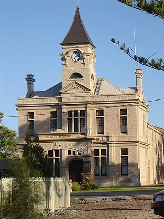
Wallaroo is a port town on the western side of Yorke Peninsula in South Australia, 160 kilometres (100 mi) northwest of Adelaide. It is one of the three Copper Triangle towns famed for their historic shared copper mining industry, and known together as "Little Cornwall", the other two being Kadina, about 8 kilometres (5 mi) to the east, and Moonta, about 18 kilometres (11 mi) south. In 2016, Wallaroo had a population of 3,988 according to the census held.

Kadina is a town on the Yorke Peninsula of the Australian state of South Australia, approximately 144 kilometres north-northwest of the state capital of Adelaide. The largest town of the Peninsula, Kadina is one of the three Copper Triangle towns famous for their shared copper mining history. The three towns are known as "Little Cornwall" for the significant number of immigrants from Cornwall who worked at the mines in the late 19th century.

Moonta is a town on the Yorke Peninsula of South Australia, 165 km (103 mi) north-northwest of the state capital of Adelaide. It is one of three towns known as the Copper Coast or "Little Cornwall" for their shared copper mining history.

Copper Coast is a region of South Australia situated in Northern Yorke Peninsula and comprising the towns of Wallaroo, Kadina, Moonta, Paskeville and Port Hughes. The area approximately bounded by Wallaroo, Kadina and Moonta is also known as the Copper Triangle. The area is so named because copper was mined from there in the late 19th and early 20th centuries, a significant source of economic prosperity for South Australia at the time. These three towns are known for their large Cornish ethnicity, often called "Little Cornwall". Kernewek Lowender is the world's largest Cornish Festival, held biennially in the Cornish Triangle. The area continues to make a significant contribution to the economy of South Australia, as a major producer of grain, particularly barley and wheat.

The Copper Coast Council is a local government area in the Australian state of South Australia located at the northern end of the Yorke Peninsula. It was established in 1997 and its seat is in Kadina.
Jerusalem is a suburb of the town of Kadina on the Yorke Peninsula. It is located in the Copper Coast Council. The boundaries were formally gazetted in January, 1999, although the name had long been in use for the area.

Wallaroo Mines is a suburb of the inland town of Kadina on the Yorke Peninsula in the Copper Coast Council area. It was named for the land division in which it was established in 1860, the Hundred of Wallaroo, as was the nearby coastal town of Wallaroo. The boundaries were formally gazetted in January 1999 for "the long established name".
Jericho is a suburb of the town of Kadina on the Yorke Peninsula. It is located in the Copper Coast Council. The boundaries were formally gazetted in January 1999, although the name had long been in use for the area. It was surveyed in 1871 as one of four "occupation blocks" to meet high demand for housing near Wallaroo Mines.
New Town is a suburb of the town of Kadina on the Yorke Peninsula. It is located in the Copper Coast Council. The boundaries were formally gazetted in January 1999, although the name had long been in use for the area.

Cross Roads is a locality at the northern end of the Yorke Peninsula and a satellite village to the town of Moonta on its east. It is located in the Copper Coast Council.
East Moonta is a rural locality at the northern end of the Yorke Peninsula and a satellite village to the town of Moonta. It is located in the Copper Coast Council.
Hamley is a locality in the Australian state of South Australia located on the Yorke Peninsula on the southern side of the urban area associated with Moonta about 130 kilometres north-west of the Adelaide city centre.
Yelta is a rural locality at the northern end of the Yorke Peninsula and a satellite village to the town of Moonta, centred on the former Yelta Mine. It is located in the Copper Coast Council. The modern locality was established when the name and boundaries were selected in January 1999.
Boors Plain is a rural locality at the north end of the Yorke Peninsula of South Australia, situated east of Moonta and south of Kadina. It is located in the Copper Coast Council.
The District Council of Kadina was a local government area in South Australia from 1888 to 1984.
Hancock's Billiard Saloon is a heritage-listed former billiard saloon and barber shop at 36-38 Taylor Street, Kadina, South Australia. It is also known as Hancock's Barber Shop and Humphries Barber Shop. It was listed on the South Australian Heritage Register on 28 May 1987 and on the former Register of the National Estate on 1 November 1983.
Kadina Cemetery is a heritage-listed cemetery in Drain Road, Kadina, South Australia. It was listed on the South Australian Heritage Register on 28 November 1985 and on the former Register of the National Estate on 1 November 1983. It is managed by the District Council of the Copper Coast.
Matta House is a heritage-listed house in Matta Road, Matta Flat, South Australia. It was listed on the South Australian Heritage Register on 24 July 1980 and on the former Register of the National Estate on 21 March 1978.
The Plain Dealer was a weekly Saturday newspaper in Kadina, South Australia, operating from 1894 until 1926 as a smaller competitor to the Kadina and Wallaroo Times.
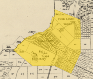
The Hundred of Wallaroo is a cadastral unit of hundred located on the Copper Coast of South Australia. It is one of the 16 hundreds of the County of Daly. It was named in 1862 by Governor Dominick Daly after the indigenous term wadla warru presumed to mean wallaby urine.
