
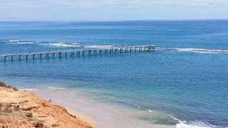
Port Noarlunga is a suburb in the City of Onkaparinga, South Australia. It is a small sea-side suburb, population 2,918, about 30 kilometres to the south of the Adelaide city centre and was originally created as a sea port. This area is now popular as a holiday destination or for permanent residents wishing to commute to Adelaide or work locally. There is a jetty that connects to a 1.6 kilometres long natural reef that is exposed at low tide. The beach is large and very long and has reasonable surfing in the South Port area whose name is taken from its location - "South of the Port".

Sellicks Beach, formerly spelt Sellick's Beach, is a suburb in the Australian state of South Australia located within Adelaide metropolitan area about 47 kilometres (29 mi) from the Adelaide city centre. It is an outer southern suburb of Adelaide and is located in the local government area of the City of Onkaparinga at the southern boundary of the metropolitan area. It is known as Witawali or Witawodli by the Traditional Owners, the Kaurna people, and is of significance as being the site of a freshwater spring said to be created by the tears of Tjilbruke, the creator being.

Aldinga Beach is an outer southern suburb of Adelaide, South Australia. It lies within the City of Onkaparinga and has the postcode 5173. At the 2011 census, Aldinga Beach had a population of 9,697. It lies about a kilometre west of the smaller suburb of Aldinga. The beach is a well-known spot for surfing, swimming, scuba diving, and snorkelling during the summer months. It overlooks an aquatic reserve which has been created to safeguard a unique reef formation.

Nepean Bay is a bay located on the north-east coast of Kangaroo Island in the Australian state of South Australia about 130 kilometres south-south-west of Adelaide. It was named by the British navigator, Matthew Flinders, after Sir Evan Nepean on 21 March 1802.

Rosetta Head, known as Kongkengguwar by the Ramindjeri people but more commonly known as The Bluff, is a headland located on the south coast of Fleurieu Peninsula in Encounter Bay, South Australia, within the local government area of the City of Victor Harbor. It is a prominent landmark on the coast, about 77 kilometres south of the state capital of Adelaide, and currently used as a recreational reserve.
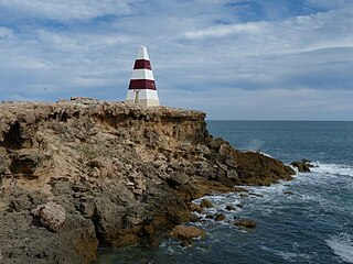
Lacepede Bay is a bay in the Australian state of South Australia located on the state's south-east coast about 140 kilometres northwest of Mount Gambier and about 240 kilometres southeast of Adelaide. It was named in 1802 by the Baudin expedition of 1800-03 after Bernard Germain de Lacépède, the French naturalist. It is one of four ‘historic bays’ located on the South Australian coast.

Point Labatt is a headland located on the west coast of Eyre Peninsula in the Australian state of South Australia about 39 kilometres south by east of Streaky Bay. It is notable as one of the largest Australian mainland breeding sites for Australian sea lions. The land and the sea adjoining Point Labatt is part of three protected areas - the Point Labatt Conservation Park, the Point Labatt Aquatic Reserve and the West Coast Bays Marine Park.
Guichen Bay, is a bay located on the south-east coast of the Australian state of South Australia about 115 kilometres northwest of the regional city of Mount Gambier and about 270 kilometres south-southeast of the state capital of Adelaide. It was named in 1802 by the Baudin expedition of 1800-03 after Luc Urbain de Bouëxic, comte de Guichen. The town of Robe is located at the southern end of the bay.

Pondalowie Bay is a bay in the Australian state of South Australia located on the west coast of the south-west tip of Yorke Peninsula in Spencer Gulf about 12 kilometres west of Marion Bay. The coastline of Pondalowie Bay is both within the gazetted locality of Inneston and the Innes National Park.

Cape Finniss is a headland located at the southern extremity of Anxious Bay on the west coast of Eyre Peninsula in South Australia about 6 kilometres Northwest by west of the town of Elliston. It is described as being ‘a rocky headland with a rounded top, 47 metres high.’ Cape Finniss is linked by a submerged reef which is considered to be ‘remnants of a once more prominent Cape Finnis(s)’ to the Waldegrave Islands which are located to the cape's north west.
Point Whidbey is a headland located at the southern western extremity of both Coffin Bay Peninsula and Avoid Bay on the west coast of Eyre Peninsula in South Australia about 34 kilometres west of the town of Coffin Bay. It was described in 2012 as being “fronted by low cliffs and rises to a round hill, 62 metres high, about 1 mile inland.” It is one of the features named by Matthew Flinders in February 1802 after his friend and Royal Navy officer, Joseph Whidbey. The point is currently located within the boundaries of the protected area, the Coffin Bay National Park.
Cape Radstock is a headland located on the west coast of Eyre Peninsula in South Australia about 45 kilometres south south-east of the town of Streaky Bay and about 9.3 kilometres (5 nmi) south east of Point Labatt. The cape is both the north western extremity of Anxious Bay and the southern extremity of the Calca Peninsula. The cape is described by one source as being “steep and bold” and where the cliffs reach a height of 135 metres, being the high point of a line of cliffs starting at Point Labatt in the west and from within Anxious Bay in the east. It was named by Matthew Flinders on 9 February 1802 after William Waldegrave, 1st Baron Radstock. Since 2012, the waters adjoining its shoreline are within a habitat protection zone in the West Coast Bays Marine Park.
Slade Point is a headland in the Australian state of South Australia located on the west coast of Eyre Peninsula in the locality of Sceale Bay about 29 kilometres (18 mi) south of the town of Streaky Bay. The point is the northern extremity of Searcy Bay and the southern extremity of a promontory that separates Searcy Bay in the south east from Sceale Bay in the north west. While it is within the coastline first charted by Matthew Flinders on 9 February 1802, it is not named by Flinders possibly due to the coastline being obscured by a thick haze. Slade Point was named in 1908 after “the late Mr. W. E. Slade” who served as the Assistant Engineer of Harbours in the South Australian Government. The cape has adjoined the boundary of the Cape Blanche Conservation Park since 2012 while the waters adjoining its shoreline have been within a habitat protection zone in the West Coast Bays Marine Park also since 2012.
Port Noarlunga Reef Aquatic Reserve is a marine protected area in the Australian state of South Australia located in waters in Gulf St Vincent adjoining the Adelaide metropolitan area and including part of the Onkaparinga River about 28 kilometres (17 mi) south-west of the state capital of Adelaide.
Royston Island is an island in the Australian state of South Australia at the northern end of Pondalowie Bay on the south-west extremity of Eyre Peninsula about 13 kilometres north-west of the town of Stenhouse Bay. The island has enjoyed protected area status since 1967 and since 1972, it has been part of the Innes National Park.
Hardwicke Bay is a bay in the Australian state of South Australia located on the west coast of Yorke Peninsula in Spencer Gulf.
Germein Bay is a bay in the Australian state of South Australia located at the northern end Spencer Gulf on the gulf's east coast to the immediate north of the city of Port Pirie. Its extent includes the port known as ‘Port Pirie’ and the former port of Port Germein. Since 2012, the majority of the bay has been within the protected area known as the Upper Spencer Gulf Marine Park.
Aldinga Reef Aquatic Reserve is a marine protected area in the Australian state of South Australia located in waters adjoining the east coast of Gulf St Vincent including land within the intertidal zone in the suburbs of Aldinga Beach and Port Willunga about 40 kilometres (25 mi) south of the state capital of Adelaide.

Sleaford Bay is a bay located in the Australian state of South Australia on the southern coast of Eyre Peninsula. It was named by the British navigator, Matthew Flinders in 1802.

