Barker Inlet

Last updated

Barker Inlet
Barker Inlet location.png
The inlet in relation to Adelaide's Central business district
Australia South Australia relief location map.png
Red pog.svg
Barker Inlet
Location South Australia
Coordinates 34°44′42″S138°30′00″E / 34.745°S 138.50°E / -34.745; 138.50 Coordinates: 34°44′42″S138°30′00″E / 34.745°S 138.50°E / -34.745; 138.50
Type Inlet
Etymology Collet Barker
Part of Gulf St Vincent
River sources Dry Creek, Little Para River
Basin  countries Australia
Settlements Adelaide

The Barker Inlet is a tidal inlet of the Gulf St Vincent in Adelaide, South Australia, named after Captain Collet Barker who first sighted it in 1831. It contains one of the southernmost mangrove forests in the world, a dolphin sanctuary, seagrass meadows and is an important fish and shellfish breeding ground. The inlet separates Torrens Island and Garden Island from the mainland to the east, and is characterised by a network of tidal creeks, artificially deepened channels, and wide mudflats. The extensive belt of mangroves are bordered by samphire saltmarsh flats and low-lying sand dunes.

Contents

There are two boardwalks (at Garden Island and St Kilda), and ships graveyards in Broad Creek, Angas Inlet and the North Arm (which is just south of North Arm Creek). The Eastern Passage runs between Garden Island and the mainland, narrowing to form Angas Channel north of North Arm Creek.

The inlet has been adversely impacted since the settlement of South Australia, with stormwater and raw sewage discharge, fishing, landfill rubbish dumping, power generation and other activities adversely affecting its flora and fauna. Much of this has changed with the landfill dump on adjacent Garden Island being closed in 2000 and remediation work begun. [1] Some stormwater is now being filtered through wetlands before discharge and the inlet has been declared a reserve for the preservation of dolphins, fish, crabs and aquatic plants. The mangroves and waterways are still affected[ when? ] by the adjacent former salt crystallization pans (closed in 2014), [2] hot wastewater discharge from Torrens Island power station, heavy metal contamination from stormwater and treated sewage, and disturbances from boat traffic.

Physical structure

Barker Inlet is a shallow tidal inlet which, with the adjacent Port River Estuary, formed during the Holocene by the progressive extension of the Lefevre Peninsula by northward littoral drift of sand carried by wave action along the eastern shore of Gulf St Vincent. [3]

It has a narrow central channel used for boating. Spring tides are over 212 metres and at low tide much of the inlet is mudflats that are above water level. Most of the creeks through the mangroves drain surrounding land and are not navigable except at high tide by very small boats. There is an artificial channel, running along the side of a breakwater, from a boat ramp at St Kilda near the inlet's northern end.[ citation needed ] The coast side of the mangroves are bounded by extensive salt evaporation ponds leased for industrial usage by the South Australian Government. Most of these salt fields are no longer used. [4]

Most of the creeks on the eastern side are tidal, although Swan Alley creek is the outlet for the Dry Creek and the Little Para River, and the North Arm Creek for the Barker Inlet Wetlands. The wetlands were created in 1994 as part of a stormwater treatment system with both tidal and freshwater sections. There is 1.72 km2 (0.66 sq mi) of constructed wetlands holding 1.2 gigalitres of stormwater before discharging via the creek. [5]

Flora and fauna

Flora

The grey mangroves are uniformly of the type Avicennia marina var. resinifera and cover most of the pre-settlement area, but the surrounding samphire salt flats have been greatly reduced in size by changes in the landform with Tecticornia flabelliformis now listed as threatened in the area. [6] The inlet's deeper sections are dominated by strap or tape weed ( Posidonia spp.). Eelgrass ( Zostera muelleri) and garweed ( Heterozostera tasmanica) dominate the shallows, often being exposed on mudflats at low tide. [7]

Fauna

Over 70 species of fish have been recorded, along with over 110 of crustaceans and almost 50 of molluscs including species such as western king prawns, King George and yellowfin whiting and blue swimmer crabs. [7] Many bird species use the inlet including cormorants, terns, ducks, swans, pelicans, egrets and herons, as well as silver gulls and white-bellied sea eagles. Including migratory birds, over 250 species have been recorded in the inlet, surrounding wetlands and lagoons. [8]

Pelicans on mudflats, Barker Inlet Barker inlet with pelicans.JPG
Pelicans on mudflats, Barker Inlet

Former uses

From 1906 until 1972, the inlet's Broad Creek was used as a landing point for explosives that were then transported by a 2.4 km (1.5 mi) tramway to the Dry Creek explosives depot. There are abandoned ships in Broad Creek, Angas Inlet and the North Arm of the Port River. The remains of over 30 iron and wooden ships abandoned up until 1945 are now bird roosts and a canoeing attraction. [9]

Protected areas and other designations

Reserves declared by the South Australian government

The Barker Inlet is associated with the following protected areas - the Adelaide Dolphin Sanctuary, the Barker Inlet-St Kilda Aquatic Reserve, the southern part of the St Kilda – Chapman Creek Aquatic Reserve and the Torrens Island Conservation Park. [10]

Non-statutory arrangements

The Baker Inlet is located both within a nationally recognised wetland system known as 'Barker Inlet & St Kilda' and at the southern extent of an Important Bird Area (IBA) known as the Gulf St Vincent Important Bird Area. [11] [12]

See also

Related Research Articles

<span class="mw-page-title-main">Protected areas of South Australia</span> Areas protected by legislation in South Australia

Protected areas of South Australia consists of protected areas located within South Australia and its immediate onshore waters and which are managed by South Australian Government agencies. As of March 2018, South Australia contains 359 separate protected areas declared under the National Parks and Wildlife Act 1972, the Crown Land Management Act 2009 and the Wilderness Protection Act 1992 which have a total land area of 211,387.48 km2 (81,617.16 sq mi) or 21.5% of the state's area.

<span class="mw-page-title-main">Spencer Gulf</span> Large inlet in South Australia

The Spencer Gulf is the westernmost and larger of two large inlets on the southern coast of Australia, in the state of South Australia, facing the Great Australian Bight. It spans from the Cape Catastrophe and Eyre Peninsula in the west to Cape Spencer and Yorke Peninsula in the east.

<span class="mw-page-title-main">Mudflat</span> Coastal wetlands where sediments have been deposited by tides or rivers

Mudflats or mud flats, also known as tidal flats or, in Ireland, slob or slobs, are coastal wetlands that form in intertidal areas where sediments have been deposited by tides or rivers. A global analysis published in 2019 suggested that tidal flat ecosystems are as extensive globally as mangroves, covering at least 127,921 km2 (49,391 sq mi) of the Earth's surface. They are found in sheltered areas such as bays, bayous, lagoons, and estuaries; they are also seen in freshwater lakes and salty lakes alike, wherein many rivers and creeks end. Mudflats may be viewed geologically as exposed layers of bay mud, resulting from deposition of estuarine silts, clays and aquatic animal detritus. Most of the sediment within a mudflat is within the intertidal zone, and thus the flat is submerged and exposed approximately twice daily.

<span class="mw-page-title-main">Western Port</span>

Western Port, commonly but unofficially known as Western Port Bay, is a large tidal bay in southern Victoria, Australia, opening into Bass Strait. It is the second largest bay in the state. Geographically, it is dominated by two large islands; French Island and Phillip Island. At the time it was renamed, its position was west of other known ports and bays, but Western Port has become something of a misnomer as it lies just to the east of the larger Port Phillip and the city of Melbourne. It is visited by Australian fur seals, whales and dolphins, as well as many migratory waders and seabirds. It is listed under the Ramsar Convention as a wetland of international significance.

<span class="mw-page-title-main">Sundarbans National Park</span> National park and nature reserve in West Bengal, India

The Sundarbans National Park is a national park, tiger reserve and biosphere reserve in West Bengal, India. It is part of the Sundarbans on the Ganges Delta and adjacent to the Sundarban Reserve Forest in Bangladesh. It is located to south-west of the Bangladesh. The delta is densely covered by mangrove forests, and is one of the largest reserves for the Bengal tiger. It is also home to a variety of bird, reptile and invertebrate species, including the salt-water crocodile. The present Sundarban National Park was declared as the core area of Sundarban Tiger Reserve in 1973 and a wildlife sanctuary in 1977. On 4 May 1984 it was declared a national park. It is a UNESCO World Heritage Site inscribed in 1987, and it has been designated as a Ramsar site since 2019. It is considered as a World Network of Biosphere Reserve from 1989.

<span class="mw-page-title-main">Port River</span> Tidal estuary north of Adelaide, South Australia

The Port River is part of a tidal estuary located north of the Adelaide city centre in the Australian state of South Australia. It has been used as a shipping channel since the beginning of European settlement of South Australia in 1836, when Colonel Light selected the site to use as a port. Before colonisation, the Port River region and the estuary area were known as Yerta Bulti by the Kaurna people, and used extensively as a source of food and plant materials to fashion artefacts used in daily life.

<span class="mw-page-title-main">Roebuck Bay</span>

Roebuck Bay is a bay on the coast of the Kimberley region of Western Australia. Its entrance is bounded in the north by the town of Broome, and in the south by Bush Point and Sandy Point. It is named after HMS Roebuck, the ship captained by William Dampier when he explored the coast of north-western Australia in 1699. The Broome Bird Observatory lies on the northern coast of the bay.

<span class="mw-page-title-main">Dry Creek, South Australia</span> Suburb of Adelaide, South Australia

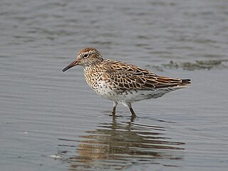
Dry Creek is a mostly industrial suburb north of Adelaide, containing significant wetlands. A substantial area was devoted to salt crystallisation pans until 2014, with plans to redevelop the site for housing.

<span class="mw-page-title-main">Broad Sound (Queensland)</span> Sound in Central Queensland, Australia

Broad Sound is a large bay on the east coast of Australia, in the state of Queensland, 675 kilometers northwest of the state capital, Brisbane. It is about 50 kilometers long and 20 kilometers across at its widest point. The Torilla Peninsula forms the eastern side of the bay; Shoalwater Bay is on the other side of the peninsula. The sound has a large tidal range of about 10 metres (33 ft). This is the largest variance on the eastern Australia coastline.

<span class="mw-page-title-main">St Kilda, South Australia</span> Suburb of Adelaide, South Australia

St Kilda is a coastal suburb in Adelaide, South Australia. Its seafront faces the Barker Inlet, which is part of the Port River estuarine area, the largest tidal estuary of Gulf St Vincent, and includes a large area of mangroves. St Kilda is an internationally recognised bird watching area with over 100 species of birds feeding in and around the mudflats, salt lagoons, mangroves and seagrass beds, which are part of the estuarine ecosystem.

<span class="mw-page-title-main">Torrens Island</span> Island in South Australia

Torrens Island is an island in the Australian state of South Australia located in the Adelaide metropolitan area in the Port River Estuary about 15 kilometres (9.3 mi) northwest of the Adelaide city centre. Since European settlement of Adelaide in 1836, it has been used for a number of purposes.

<span class="mw-page-title-main">Gulf St Vincent Important Bird Area</span>

The Gulf St Vincent Important Bird Area comprises land extending along the coast of Gulf St Vincent, north of Adelaide, South Australia.

Torrens Island Conservation Park is a protected area in the Australian state of South Australia located on Torrens Island in the Adelaide metropolitan area about 17 kilometres north-northwest of the state capital of Adelaide and about 3.9 kilometres north-northeast of Port Adelaide.

<span class="mw-page-title-main">Adelaide International Bird Sanctuary National Park—Winaityinaityi Pangkara</span> Protected area in South Australia

The Adelaide International Bird Sanctuary National Park—Winaityinaityi Pangkara is a protected area in South Australia established by the South Australian government on the northeast coast of Gulf St Vincent, between Parham in the north and the southern end of Barker Inlet in the south, for the purpose of rehabilitating land used as salt pans, protecting habitat for international migratory shorebirds, managing water quality in adjoining parts of Gulf St Vincent, creation of "green" space, development of niche tourism and creation of opportunities for Indigenous people.

<span class="mw-page-title-main">Garden Island (South Australia)</span> Island in South Australia

Garden Island is an island in the Australian state of South Australia located about 14 kilometres (8.7 mi) north-west of the capital city of Adelaide in an estuary system within the Adelaide metropolitan area which drains into Gulf St Vincent. It is notable as being a site for a mangrove forest, a landfill, a part of the site for the Multifunction Polis, a ship graveyard and a venue for recreational boating activities. It has enjoyed varying degrees of protected area status since 1973.

Barker Inlet – St Kilda Aquatic Reserve is a marine protected area in the Australian state of South Australia located in waters adjoining the east coast of Gulf St Vincent in Barker Inlet about 16 kilometres (9.9 mi) north of the state capital of Adelaide.

St Kilda – Chapman Creek Aquatic Reserve is a marine protected area in the Australian state of South Australia located in waters on the east coast of Gulf St Vincent adjoining the suburbs of Buckland Park and St Kilda about 24.8 kilometres (15.4 mi) north of the state capital of Adelaide.

<span class="mw-page-title-main">Adelaide Dolphin Sanctuary</span> Protected area in South Australia

Adelaide Dolphin Sanctuary (ADS) is a marine protected area in the Australian state of South Australia located on the east coast of Gulf St Vincent in and adjoining the north-western part of Adelaide, covering the estuary of the Port River around Port Adelaide and northwards past St Kilda. It was established in 2005 for the protection of a resident population of Indo-Pacific bottlenose dolphins.

The St Kilda saltfields brine spill is an ongoing environmental disaster occurring in St Kilda, South Australia. Former salt production ponds are leaking brine into adjacent wetlands causing death and distress to mangroves, the salt marsh and intertidal ecological communities of Barker Inlet.

References

  1. Thomas, Brett; Fitzpatrick R; Merry R. (July 2001). "Literature Review of Acid Sulfate Soils and the environment in the Barker Inlet/ Gillman area" (PDF). CSIRO Land and Water. Archived from the original (PDF) on 20 September 2006. Retrieved 2006-12-26.
  2. Tauriello, Giuseppe (27 September 2014). "Ridley seeks Dry Creek offers". The Advertiser. Retrieved 7 June 2020.
  3. Bowman, G. & Harvey, N. (1986): Geomorphic Evolution of a Holocene Beach-Ridge Complex, LeFevre Peninsula, South Australia. Journal of Coastal Research 2(3):345-362
  4. "Dry Creek salt fields". Business & Industry. Environmental Protection Agency. Archived from the original on 7 June 2020. Retrieved 7 June 2020.
  5. "A cleaner future for the dolphins of Barker Inlet (media release)". Department of the Environment and Heritage. 21 September 2001. Archived from the original on 10 September 2006. Retrieved 2006-12-26.
  6. Edyvane, K (2000). "Ecology". Barker Inlet Port Estuary Committee. Archived from the original on 25 August 2006. Retrieved 26 December 2006.
  7. 1 2 The Port River. City of Port Adelaide Enfield. 2001. pp. 4, 44. ISBN   0-646-40920-4.
  8. "Important Bird Areas factsheet: Gulf St Vincent". BirdLife International. 2014. Retrieved 21 October 2014.
  9. "Port Adelaide Ships' Graveyards". South Australian Department of Environment and Heritage. Retrieved 26 December 2006.
  10. "Search result for "Barker Inlet-St Kilda Aquatic Reserve" with the following databases selected - "Suburbs and Localities", "Aquatic Reserves", "Dolphin Sanctuary" and "NPW and Conservation Reserve Boundaries", "Coastline MHWM" and "Metropolitan Adelaide Boundary (Development Act 1993)"". Location SA Map Viewer. Government of South Australia. Retrieved 15 October 2016.
  11. "Search result for "Barker Inlet & St Kilda - SA005"". Directory of Important Wetlands. Department of Environment and Energy, Government of Australia. Retrieved 15 October 2016.
  12. Dutson, Guy; Garnett, Stephen; Gole, Cheryl (October 2009). Australia’s Important Bird Areas, Key sites for bird conservation (PDF). Birds Australia. p. 33. Retrieved 5 October 2014.