
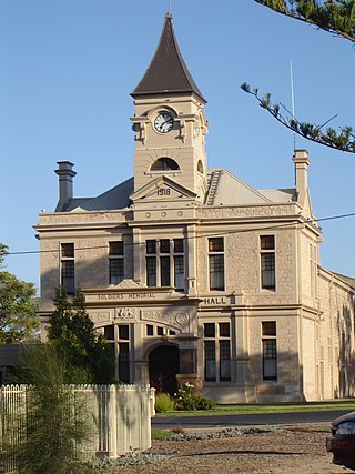
Port Lincoln is a city on the Lower Eyre Peninsula in the Australian state of South Australia. Known as Galinyala by the traditional owners, the Barngarla people, it is situated on the shore of Boston Bay, which opens eastward into Spencer Gulf. It is the largest city in the West Coast region, and is located approximately 280 km (170 mi) from the state's capital city of Adelaide.

The Eyre Peninsula is a triangular peninsula in South Australia. It is bounded by the Spencer Gulf on the east, the Great Australian Bight on the west, and the Gawler Ranges to the north.
Wallaroo is a port town on the western side of Yorke Peninsula in South Australia, 160 kilometres (100 mi) northwest of Adelaide. It is one of the three Copper Triangle towns famed for their historic shared copper mining industry, and known together as "Little Cornwall", the other two being Kadina, about 8 kilometres (5 mi) to the east, and Moonta, about 18 kilometres (11 mi) south. In 2016, Wallaroo had a population of 3,988 according to the census held.
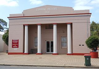
Cummins is a town on Eyre Peninsula in South Australia, 67 km north of Port Lincoln and 60 m above sea level.

Thevenard is a port town in the far west of Eyre Peninsula, South Australia. It is contiguous with the larger town of Ceduna. Its name derives from nearby Cape Thevenard, which in turn was named after Antoine-Jean-Marie Thévenard, a French admiral. In the 2021 census, Thevenard had a population of 563.

Kimba is a rural service town on the Eyre Highway at the top of Eyre Peninsula in the Australian state of South Australia with an annual rainfall of 348 millimetres (13.7 in). There is an 8-metre (26 ft) tall statue of a galah beside the highway, marking halfway between the east and west coasts of Australia. The Gawler Ranges are north of the highway near the town.

Wudinna is a town of about 500 people on the Eyre Highway in the wheat-growing region of Eyre Peninsula, South Australia.
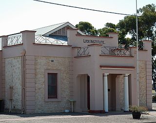
Lock is a town in the centre of Eyre Peninsula in South Australia. It is central Eyre Peninsula's main grain storage hub, as it is surrounded by a predominantly farming community, with emphasis on cereal crop production. The town has a hotel, caravan park, motel, supermarket, post office, police station, library, sporting complex, golf and bowling clubs and area school. At the 2006 census, Lock had a population of 290.
Wirrulla is a small grain belt town located 60 km from Streaky Bay on the Eyre Peninsula. The town is a focus point for many of the surrounding agricultural districts, and features a number of silos used to store grain from the surrounding areas. The name of the town is derived from an Aboriginal word meaning "to make haste, to be quick".
Ungarra is a small swamp town located on the Eyre Peninsula, in the Australian state of South Australia about 248 kilometres (154 mi) from the state's capital, Adelaide and around 80 kilometres (50 mi) north of Port Lincoln. At the 2021 census, Ungarra had a population of 156. This has decreased since the 2006 census, when Ungarra is recorded to have a population of 241.
Darke Peak is a small agricultural town located in central Eyre Peninsula, South Australia. The town is the population centre for the surrounding agricultural district and has become a minor historical tourist town. It is situated on Barngarla lands. The J. C. Darke Memorial and Grave, commemorating early European explorer John Charles Darke, is located near the township and is located on the South Australian Heritage Register.

Kyancutta is a small wheatbelt town at the junction of the Eyre and Tod Highways on the Eyre Peninsula in South Australia. Once a busy town with an airport, Kyancutta is now nearly a ghost town, acting only as a centre for the agricultural districts surrounding it, as well as passing tourists.

Penong is a town and locality on the Nullarbor Plain, in the far west of the state of South Australia located about 616 kilometres (383 mi) north-west of the state capital of Adelaide. With no settlements between it and Border Village on the border with Western Australia, 400 km (250 mi) away on the Eyre Highway, it is a popular rest-stop for travellers.

The Eyre Peninsula Railway is a 1,067 mm gauge railway on the Eyre Peninsula of South Australia. Radiating out from the ports at Port Lincoln and Thevenard, it is isolated from the rest of the South Australian railway network. It peaked at 777 kilometres in 1950; today only a 60 kilometre section remains open. It is currently operated by Aurizon.
This article describes the railway stations on the Eyre Peninsula of South Australia that were located on the lines of the Port Lincoln Division of the former South Australian Railways (SAR). Few of them were staffed. All stations were closed in 1968 when the SAR withdrew all passenger services.

Warramboo (wɔrˑræmˑbʉː) is a locality in the Australian state of South Australia located on the Eyre Peninsula about 334 kilometres (208 mi) north-west of the state capital of Adelaide and about 26 kilometres (16 mi) south-east of the municipal seat of Wudinna. It is 189 kilometres (117 mi) north of Port Lincoln on the Tod Highway and is the north-western terminus of the wheat haulage lines radiating from Port Lincoln on the Eyre Peninsula Railway. The railway line was built from 1907–1915 to develop the cereal industry. The grain silos are a distinctive local landmark of the town.
Yeelanna is a town on the Lower Eyre Peninsula in South Australia located 77 kilometres (48 mi) north of Port Lincoln. It is on the Tod Highway and Eyre Peninsula Railway between Lock and Cummins. The Yeelanna district is known for its extremely fertile farming land, where nearly all farms in the district are continuously cropped.
Edillilie is a small town on Eyre Peninsula in South Australia. It is on the Tod Highway and Eyre Peninsula Railway north of Port Lincoln.
Cunyarie is a locality on northern Eyre Peninsula in South Australia. The Hundred of Cunyarie was proclaimed in 1922 and the town was surveyed in November 1927. Land was released, surveyed and apportioned on an application basis, with the latest sections being surveyed as late as the 1960s and 1970s. However, the limiting factor for early settlers was the availability of water, and allocations were generally preferentially selected around rare rocky outcrops or uplands which could afford some opportunities for increased runoff into earthen dams. Indeed, access to water was a critical factor in European settlement of Eyre Peninsula.
Moody Tank Conservation Park is a protected area located in the Australian state of South Australia on the Eyre Peninsula about 26 kilometres north-east of Cummins.

