
Port Phillip or Port Phillip Bay is a horsehead-shaped enclosed bay on the central coast of southern Victoria, Australia. The bay opens into the Bass Strait via a short, narrow channel known as The Rip, and is completely surrounded by localities of Victoria's two largest cities — metropolitan Greater Melbourne in the bay's main eastern portion north of the Mornington Peninsula, and the city of Greater Geelong in the much smaller western portion north of the Bellarine Peninsula. Geographically, the bay covers 1,930 km2 (750 sq mi) and the shore stretches roughly 264 km (164 mi), with the volume of water around 25 km3 (6.0 cu mi). Most of the bay is navigable, although it is extremely shallow for its size — the deepest portion is only 24 m (79 ft) and half the bay is shallower than 8 m (26 ft). Its waters and coast are home to seals, whales, dolphins, corals and many kinds of seabirds and migratory waders.

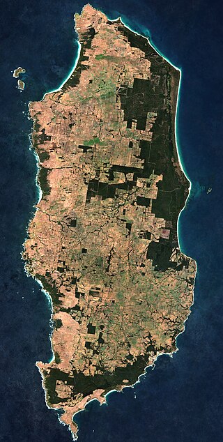
Phillip Island is an Australian island about 125 km (78 mi) south-southeast of Melbourne, Victoria. The island is named after Governor Arthur Phillip, the first Governor of New South Wales, by explorer and seaman George Bass, who sailed in a whaleboat, arriving from Sydney on 5 January 1798.

The Mornington Peninsula is a peninsula located south of Melbourne, Victoria, Australia. It is surrounded by Port Phillip to the west, Western Port to the east and Bass Strait to the south, and is connected to the mainland in the north. Geographically, the peninsula begins its protrusion from the mainland in the area between Pearcedale and an area north of Frankston. The area was originally home to the Mayone-bulluk and Boonwurrung-Balluk clans, and formed part of the Boonwurrung nation's territory prior to European settlement.
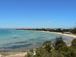
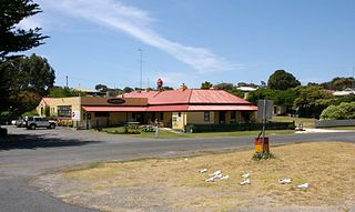
Sorrento is a coastal suburb on the Mornington Peninsula in Melbourne, Victoria, Australia, 103 km (64 mi) south-west of Melbourne's Central Business District, located within the Shire of Mornington Peninsula local government area. Sorrento recorded a population of 2,013 at the 2021 census. Sorrento is known for its appealing weather, limestone buildings, and its world-class day-spas, which take advantage of the local water pressure to provide an unparalelled scrub.
King Island is an island in the Bass Strait, belonging to the Australian state of Tasmania. It is the largest of four islands known as the New Year Group and the second-largest island in Bass Strait. The island's population at the 2016 census was 1,585 people, up from 1,566 in 2011. The local government area of the island is the King Island Council.

Lysterfield is a suburb in Melbourne, Victoria, Australia, 32 km south-east of Melbourne's Melbourne CBD, located within the City of Knox and the Yarra Ranges Shire local government areas. Lysterfield recorded a population of 6,681 at the 2021 census.

Arthurs Seat is a mountainous and small locality on the Mornington Peninsula in Melbourne, Victoria, Australia, about 85 km south east of Melbourne's Central Business District, located within the Shire of Mornington Peninsula local government area. Arthurs Seat recorded a population of 414 at the 2021 census.
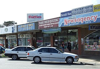
Tyabb is a township and Country town locality on the Mornington Peninsula in Melbourne, Victoria, Australia, 53 km (33 mi) south-east of Melbourne's central business district, located within the Shire of Mornington Peninsula local government area. Tyabb recorded a population of 3,449 at the 2021 census.

Point Nepean marks the southern point of The Rip and the most westerly point of the Mornington Peninsula, in Victoria, Australia. It was named in 1802 after the British politician and colonial administrator Sir Evan Nepean by John Murray in HMS Lady Nelson. Its coast and adjacent waters are included in the Port Phillip Heads Marine National Park, while its land area is part of the Point Nepean National Park. The point includes Cheviot Beach on its southern side, notable as the site of the disappearance in 1967 of Australia's then-Prime Minister Harold Holt.
The Boonwurrung, also spelt Bunurong or Bun wurrung, are an Aboriginal people of the Kulin nation, who are the traditional owners of the land from the Werribee River to Wilsons Promontory in the Australian state of Victoria. Their territory includes part of what is now the city and suburbs of Melbourne. They were called the Western Port or Port Philip tribe by the early settlers, and were in alliance with other tribes in the Kulin nation, having particularly strong ties to the Wurundjeri people.
Wonthaggi is a seaside town located 132 kilometres (82 mi) south east of Melbourne via the South Gippsland and Bass highways, in the Bass Coast Shire of Gippsland, Victoria, Australia. Known originally for its coal mining, it is now the largest town in South Gippsland, a regional area with extensive tourism, beef and dairy industries.
Nelson is a small fishing town in Victoria, Australia. It is located at the mouth of the Glenelg River and Discovery Bay, a few kilometres from the South Australian border, and 422 kilometres (262 mi) west of Melbourne. At the 2016 census, Nelson and the surrounding area had a population of 190.

Cape Bridgewater is a locality in the Australian state of Victoria located on the western shore of Bridgewater Bay about 21 kilometres (13 mi) south-west of Portland and about 383 kilometres (238 mi) west of Melbourne.
Portland Bay is a small bay off the coast of Victoria, Australia. It is about 360 kilometres (220 mi) west of Melbourne. The city of Portland is located on the bay. The western end of the bay is marked by the headland of Point Danger.
Lady Julia Percy Island, known as Deen Maar or Dhinmar in the Gunditjmara language, lies 8.1 kilometres (5.0 mi) off the coast, in the Barwon South West region of Victoria, Australia in Bass Strait. The island is an unincorporated area under the direct administration of the Government of Victoria.
Cape Otway is a cape and a bounded locality of the Colac Otway Shire in southern Victoria, Australia on the Great Ocean Road; much of the area is enclosed in the Great Otway National Park. The cape marks the boundary between the Southern Ocean on the west and Bass Strait on the east.
St Andrews Beach is a coastal village in the southern extremity of the Mornington Peninsula in Melbourne, Victoria, Australia, 68 km (42 mi) south of Melbourne's Central Business District, located within the Shire of Mornington Peninsula local government area. St Andrews Beach recorded a population of 974 at the 2021 census.
The Powlett River is a perennial river of the West Gippsland catchment, located in the West Gippsland region of the Australian state of Victoria.
The Boonwurrung language, also anglicised as Bunurong, Bun wurrung, and other variant spellings, is an Aboriginal Australian language traditionally spoken by the Boonwurrung people of the Kulin nation of central Victoria prior to European settlement in the colony of Victoria. The last remaining traditional native speakers died in the early 20th century.

Pulpit Rock is a rock located in Cape Schanck, Victoria, Australia. It is in the Mornington Peninsula National Park, near the Bass Strait.


