
The Shire of Mornington Peninsula is a local government area in Victoria, Australia. It is located to the south of the city of Melbourne on the Mornington Peninsula. It has an area of 724 square kilometres and in June 2018 it had a population of 165,822.

The Mornington Peninsula National Park is a national park located in the Greater Melbourne region of Victoria, Australia. The 2,686-hectare (6,640-acre) national park is situated approximately 90 kilometres (56 mi) south of Melbourne on the Mornington Peninsula.

The Mornington Peninsula is a peninsula located south-east of Melbourne, Victoria, Australia. It is surrounded by Port Phillip to the west, Western Port to the east and Bass Strait to the south, and is connected to the mainland in the north. Geographically, the peninsula begins its protrusion from the mainland in the area between Pearcedale and an area south of Frankston. The area was originally home to the Mayone-bulluk and Boonwurrung-Balluk clans and formed part of the Boonwurrung nation's territory prior to European settlement.

Dromana is a town located 75km south of Melbourne on the Mornington Peninsula. Its local government area is the Shire of Mornington Peninsula.

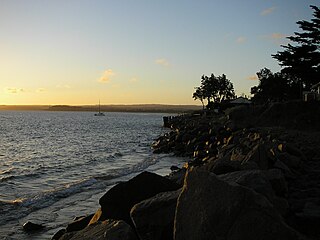
Flinders once known as Mendi-Moke, is a town south of Melbourne, Victoria, Australia, located on the Mornington Peninsula at the point where Western Port meets Bass Strait. Its local government area is the Shire of Mornington Peninsula. At the 2016 census, Flinders had a population of 905.

Hastings is a large fishing town and port on the Mornington Peninsula, Victoria, Australia, as a part of the urban enclave on Western Port comprising Hastings, Bittern, Crib Point, Tyabb, and Somerville. Its local government area is the Shire of Mornington Peninsula. It is served by Hastings railway station on the Stony Point greater-metropolitan line.

Merricks is a small town in Victoria, Australia in the southeastern Mornington Peninsula between Hastings and Flinders. Its local government area is the Shire of Mornington Peninsula.

Merricks North is a rural locality in the south side of Victoria, Australia. Its local government area is the Shire of Mornington Peninsula.

Mornington is a seaside town on the edge of wider Melbourne on the Mornington Peninsula, Victoria, Australia, located 57 km (35 mi) south of Melbourne's central business district. It is in the local government area of the Shire of Mornington Peninsula.
Mount Martha is a seaside town south east of Melbourne, Victoria, Australia 68 kilometres (42 mi) south-east of Melbourne's central business district. Its local government area is the Shire of Mornington Peninsula. It is on the south-eastern shores of Port Phillip and offers a bathing beach. A boardwalk winds its way for more than 5 kilometres (3 mi) along the Balcombe Creek, its North beach mouth to the Briars Historic Park. The suburb's highest point bears the area's name and reaches 160 metres (520 ft). The peak was named after Martha Lonsdale, the wife of the colonist William Lonsdale.
Safety Beach is a bayside residential township on the Mornington Peninsula, Victoria, Australia. Its local government area is the Shire of Mornington Peninsula. At the 2016 census, Safety Beach had a population of 4,821.
Somers is a small town approximately 90 km south-east of Melbourne, Victoria, Australia, in the south-eastern corner of the Mornington Peninsula on Western Port. Its local government area is the Shire of Mornington Peninsula.
St Andrews Beach is located on the Bass Strait side of the southern Mornington Peninsula and it is south of Rye. It was first subdivided in the 1959 and the subdivision was originally marketed as "Capri Beach". In the 1962 a golf course was constructed and the subdivision was remarketed as St. Andrews by the Sea. Originally the homes that were built were small holiday homes but later in the 20th century more substantial homes began to be built as its location became more appreciated. At this time the name St Andrews Beach was adopted by the Council as its official name. The price of land in this area has increased dramatically over the last 10 years.
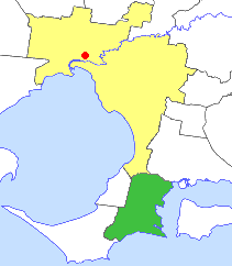
The Shire of Hastings was a local government area about 60 kilometres (37 mi) south-southeast of Melbourne, the state capital of Victoria, Australia, encompassing the eastern extremity of the Mornington Peninsula. The shire covered an area of 304.6 square kilometres (117.6 sq mi), and existed from 1960 until 1994.
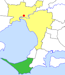
The Shire of Flinders was a local government area, encompassing the extremity of the Mornington Peninsula, about 65 kilometres (40 mi) south of Melbourne, the state capital of Victoria, Australia. The shire covered an area of 324 square kilometres (125.1 sq mi), and existed from 1874 until 1994.
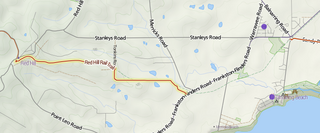
Red Hill Rail Trail is a 6.5 kilometre rail trail connecting Red Hill with Merricks, on the Mornington Peninsula, Victoria, Australia. It is primarily used by horse riders. It has gravel, dirt and grass surfaces.
Fingal is a rural locality of the Mornington Peninsula abutting Bass Strait along Gunnamatta Beach and lying between the suburbs of Rye and Cape Schanck. Its local government area is the Shire of Mornington Peninsula.

The Coolart Wetlands and Homestead Reserve, or just Coolart, is an 87.5 ha estate on the Western Port coast of the Mornington Peninsula of Victoria, south-eastern Australia, about 70 km south-east of Melbourne. It comprises a late 19th-century mansion-like homestead and surrounding grounds west of the village of Somers. Coolart is the remnant of one of the oldest grazing properties on the Mornington Peninsula. The homestead is set in a garden with adjacent wetlands and coastal woodlands with walking tracks. It is managed by Parks Victoria and the homestead is open to the public. The homestead features an exhibition of historic photographs, and hosts changing art exhibitions. Coolart is a popular venue for picnics, nature walks and birdwatching.

The Mornington Peninsula is an Australian wine region located south of Melbourne, Victoria. The region has a cool climate making wine growing ideal and focuses on Pinot noir production but has had success with other varietals including Chardonnay, Pinot gris and Tempranillo. The region is known for its medium bodied, dry wines and sparkling wines that show structure and complexity. The still wine versions of Chardonnay reflect a diversity of styles, all typically oaked, from more citrus to more tropical fruit flavors.


