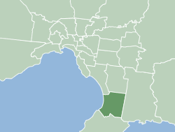
The City of Frankston is a local government area (LGA) in Victoria, Australia in the southern suburbs of Melbourne. It has an area of 130 square kilometres, and in June 2018, the City of Frankston recorded a population of 141,845.

The Mornington Peninsula is a peninsula located south of Melbourne, Victoria, Australia. It is surrounded by Port Phillip to the west, Western Port to the east and Bass Strait to the south, and is connected to the mainland in the north. Geographically, the peninsula begins its protrusion from the mainland in the area between Pearcedale and an area north of Frankston. The area was originally home to the Mayone-bulluk and Boonwurrung-Balluk clans and formed part of the Boonwurrung nation's territory prior to European settlement.

Pearcedale is a township and coastal rural locality in Victoria, Australia, 49 km south-east of Melbourne's Central Business District, located within the City of Casey and the Shire of Mornington Peninsula local government areas. Pearcedale recorded a population of 3,867 at the 2021 census.

Frankston is a suburb in Melbourne, Victoria, Australia, 41 km (25 mi) south-east of Melbourne's Central Business District, located within the City of Frankston local government area. Frankston recorded a population of 37,331 at the 2021 census.
Langwarrin is a suburb in Melbourne, Victoria, Australia, 42 km (26 mi) south-east of Melbourne's Central Business District, located within the City of Frankston local government area. Langwarrin recorded a population of 23,588 at the 2021 census.

Balnarring is a town in the south-eastern extremity of the Mornington Peninsula in Melbourne, Victoria, Australia, approximately 63 km (39 mi) south-east of Melbourne's Central Business District, located within the Shire of Mornington Peninsula local government area. Balnarring recorded a population of 2,371 at the 2021 census.

Bittern is a town on the Mornington Peninsula in Melbourne, Victoria, Australia, 61 km (38 mi) south-east of Melbourne's Central Business District, located within the Shire of Mornington Peninsula local government area. Bittern recorded a population of 4,276 at the 2021 census.

Merricks is a town in the south-eastern extremity of the Mornington Peninsula in Melbourne, Victoria, Australia, approximately 65 km (40 mi) south-east of Melbourne's Central Business District, located within the Shire of Mornington Peninsula local government area. Merricks recorded a population of 184 at the 2021 census.

Moorooduc is a rural township on the Mornington Peninsula in Melbourne, Victoria, Australia, 54 km (34 mi) south-east of Melbourne's central business district, located within the Shire of Mornington Peninsula local government area. Moorooduc recorded a population of 1,004 at the 2021 census.
Mount Martha is a suburb on the Mornington Peninsula in Melbourne, Victoria, Australia, 50 kilometres (31 mi) south-east of Melbourne's Central Business District, located within the Shire of Mornington Peninsula local government area. Mount Martha recorded a population of 19,746 at the 2021 census.

Shoreham is a seaside surfing town located on the shore of Western Port bay on the Mornington Peninsula in the Australian state of Victoria. It lies within the Shire of Mornington Peninsula local government area, about 68 km (42 mi) south-east of the central business district of Melbourne. Shoreham recorded a population of 679 at the 2021 census.

Somerville is a town on the Mornington Peninsula in Melbourne, Victoria, Australia, 49 km (30 mi) south-east of Melbourne's Central Business District, located within the Shire of Mornington Peninsula local government area. Somerville recorded a population of 11,767 at the 2021 census.
Tyabb is a township and semi rural locality on the Mornington Peninsula in Melbourne, Victoria, Australia, 53 km (33 mi) south-east of Melbourne's central business district, located within the Shire of Mornington Peninsula local government area. Tyabb recorded a population of 3,449 at the 2021 census.

Frankston railway station, in Victoria, Australia, is the terminus of the suburban electrified Frankston line and diesel-hauled services on the Stony Point line. It serves the south-eastern Melbourne suburb of Frankston, and opened on 1 August 1882.

Baxter railway station is located on the Stony Point line in Victoria, Australia. It serves the town of Baxter, and it opened on 1 October 1888 as Mornington Junction. It was renamed Baxter on 6 May 1918.

The Stony Point line is a commuter railway line in the outer metropolitan area of Melbourne, Victoria, Australia. Operated by Metro Trains Melbourne, it is the city's only diesel service on the metropolitan network and the tenth longest line at 31 kilometres (19 mi). The line acts as an extension of the Frankston line with services running from Frankston station to the small town of Stony Point in the south-east, serving 10 stations via Leawarra, Baxter, Hastings, and Bittern. The line operates for approximately 13 hours a day, unlike other lines on the network, which provide 24-hour service on Friday and Saturday nights. Headways of 90 to 120 minutes are operated throughout the day due to limited patronage and infrastructure constraints. Trains on the Stony Point line run as two one-car formations of V/Line Sprinter DMUs.

McCrae is a suburb on the Mornington Peninsula in Melbourne, Victoria, Australia, 59 km (37 mi) south of Melbourne's Central Business District, located within the Shire of Mornington Peninsula local government area. McCrae recorded a population of 3,311 at the 2021 census.
Moorooduc Highway is a 16 km highway which runs from Frankston to Tuerong and, together with the Mornington Peninsula Freeway, was part of the main route from Melbourne to the Mornington Peninsula until the completion of Peninsula Link in 2013. This name is not widely known to most drivers, as the entire allocation is still best known as by the names of its constituent parts: McMahons Road, Frankston–Flinders Road, and Moorooduc Road.

Frankston South is a suburb in Melbourne, Victoria, Australia, 43 km south-east of Melbourne's Central Business District, located within the City of Frankston local government area. Frankston South recorded a population of 18,801 at the 2021 census.

The Shire of Mornington was a local government area about 50 kilometres (30 mi) south of Melbourne, the state capital of Victoria, Australia, encompassing the western extremity of the Mornington Peninsula. The shire covered an area of 90.65 square kilometres (35.0 sq mi) immediately to the south of Frankston, and existed from 1860 until 1994.


