
The Shire of Mornington Peninsula is a local government area in Victoria, Australia. It is located to the south of the city of Melbourne on the Mornington Peninsula. It has an area of 724 square kilometres and in June 2018 it had a population of 165,822.

The Mornington Peninsula is a peninsula located south-east of Melbourne, Victoria, Australia. It is surrounded by Port Phillip to the west, Western Port to the east and Bass Strait to the south, and is connected to the mainland in the north. Geographically, the peninsula begins its protrusion from the mainland in the area between Pearcedale and an area south of Frankston. The area was originally home to the Mayone-bulluk and Boonwurrung-Balluk clans and formed part of the Boonwurrung nation's territory prior to European settlement.

Pearcedale is a township and coastal rural locality in Victoria, Australia, 49 km south-east of Melbourne's central business district. Its local government areas are the City of Casey and the Shire of Mornington Peninsula. A bus service operates to and from Frankston railway station via Baxter. At the 2016 Census, Pearcedale had a population of 3,821.

Frankston is a suburb of Melbourne in Victoria, Australia, in the local government area of the City of Frankston. It is located 41 km south-east of the Melbourne city centre, north of the Mornington Peninsula. Due to its geographic location, it is often referred to as "the gateway to the Mornington Peninsula".

Arthurs Seat is a mountainous and small locality on the Mornington Peninsula, within the Shire of Mornington Peninsula, about 85 km south east of Melbourne, Australia, noted for its exclusivity and the general affluence of the demographics which make up the enclave. The Aboriginal Boonwurrung name for the hill is Wonga.

Balnarring Beach is a town in Victoria, Australia, 2 km south of Balnarring. Its local government area is the Shire of Mornington Peninsula and at the 2016 Census, Balnarring Beach had a population of 418. In 2006 it was rated by the Keep Australia Beautiful Council as 'Australia's Cleanest Beach', out of 317 beaches in five states.

Boneo is a rural locality south of Melbourne, Victoria, Australia, south of and inland from Rosebud on the Mornington Peninsula. Its local government area is the Shire of Mornington Peninsula.

Flinders once known as Mendi-Moke, is a town south of Melbourne, Victoria, Australia, located on the Mornington Peninsula at the point where Western Port meets Bass Strait. Its local government area is the Shire of Mornington Peninsula. At the 2016 census, Flinders had a population of 905.

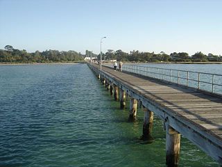
Hastings is a suburb of Melbourne on the Mornington Peninsula, Victoria, Australia, as a part of the urban enclave on Western Port comprising Hastings, Bittern, Crib Point, Tyabb, and Somerville. Its local government area is the Shire of Mornington Peninsula. It is served by Hastings railway station on the Stony Point greater-metropolitan line.
Moorooduc is a rural township in Victoria, Australia. Its local government area is the Shire of Mornington Peninsula.

Mornington is a seaside suburb of Melbourne on the Mornington Peninsula, Victoria, Australia, located 57 km (35 mi) south of Melbourne's central business district. It is in the local government area of the Shire of Mornington Peninsula.

Mount Martha is a seaside suburb of Melbourne, Victoria, Australia 68 kilometres (42 mi) south-east of Melbourne's central business district. Its local government area is the Shire of Mornington Peninsula. It is on the south-eastern shores of Port Phillip and offers a bathing beach. A boardwalk winds its way for more than 5 kilometres (3 mi) along the Balcombe Creek, its North beach mouth to the Briars Historic Park. The suburb's highest point bears the area's name and reaches 160 metres (520 ft). The peak was named in 1836 after Captain William Hobson’s mother, Martha Jones.

Red Hill is a small town and rural community, located in the hinterland of the Mornington Peninsula, about an hour's drive south of Melbourne, in Victoria, Australia. Its local government area is the Shire of Mornington Peninsula. At the 2016 census, Red Hill had a population of 924.
Red Hill South is a rural locality and township on the Mornington Peninsula, Victoria, Australia. Its local government area is the Shire of Mornington Peninsula. At the 2016 census, Red Hill South had a population of 603.
Rosebud is a seaside suburb of Melbourne on the Mornington Peninsula, Victoria, Australia approximately 75 km South of Melbourne’s central business district. It is wedged between the lower slopes of Arthurs Seat, the shores of Port Phillip and the plains of Boneo. Its local government area is the Shire of Mornington Peninsula. Rosebud is a popular tourist resort with families who appreciate its sandy beaches and shallow waters.

Shoreham is a seaside surfing town south of Melbourne, Victoria, Australia in the southern Mornington Peninsula region on the Western Port. Shoreham is situated on the shore of Western Port around the mouth of Stoney Creek. Its local government area is the Shire of Mornington Peninsula. It is a coastal recreation resort rich in artistic history, notable for its pine-covered cliffs, foreshore reserve, and Honeysuckle Beach. At the 2016 census, Shoreham had a population of 608.
Christmas Hills is a town in Victoria, Australia, 35 km north-east of Melbourne's Central Business District in the local government area of the Shire of Nillumbik. At the 2016 Census, Christmas Hills had a population of 355.

Hornsby Shire is a local government area situated in Northern Sydney, as well as parts of the Hills District, in the state of New South Wales, Australia. The shire stretches from the M2 Hills Motorway in the south to the Hawkesbury River town of Wisemans Ferry, some 53 kilometres (33 mi) to the north, making it the largest local government council in the Greater Sydney Metropolitan region by total area. As of the 2016 census the shire had an estimated population of 142,667.

Wollondilly Shire is a periurban local government area adjacent to the south-western fringe of Sydney, parts of which fall into the Macarthur, Blue Mountains and Central Tablelands regions in the state of New South Wales, Australia.
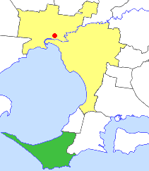
The Shire of Flinders was a local government area, encompassing the extremity of the Mornington Peninsula, about 65 kilometres (40 mi) south of Melbourne, the state capital of Victoria, Australia. The shire covered an area of 324 square kilometres (125.1 sq mi), and existed from 1874 until 1994.

