This article describes the history of the Australian colony and state of Victoria.

Hamilton Hume was an early explorer of the present-day Australian states of New South Wales and Victoria. In 1824, along with William Hovell, Hume participated in an expedition that first took an overland route from Sydney to Port Phillip. Along with Sturt in 1828, he was part of an expedition of the first Europeans to find the Darling River.

William Hilton Hovell was an English explorer of Australia. With Hamilton Hume, he made an 1824 overland expedition from Sydney to Port Phillip, and later explored the area around Western Port.

The Hume and Hovell expedition was a journey of exploration undertaken in eastern Australia. In 1824 the Governor of New South Wales, Sir Thomas Brisbane, commissioned Hamilton Hume and former Royal Navy Captain William Hovell to lead an expedition to find new grazing land in the south of the colony, and also to find an answer to the mystery of where New South Wales's western rivers flowed.

Risdon Cove is a cove located on the east bank of the Derwent River, approximately 7 kilometres (4 mi) north of Hobart, Tasmania. It was the site of the first British settlement in Van Diemen's Land, now Tasmania, the island state of Australia. The cove was named by John Hayes, who mapped the river in the ship Duke of Clarence in 1794, after his second officer William Bellamy Risdon.

Western Port, commonly but unofficially known as Western Port Bay, is a large tidal bay in southern Victoria, Australia, opening into Bass Strait. It is the second largest bay in the state. Geographically, it is dominated by two large islands; French Island and Phillip Island. At the time it was renamed, its position was west of other known ports and bays, but Western Port has become something of a misnomer as it lies just to the east of the larger Port Phillip and the city of Melbourne. It is visited by Australian fur seals, whales and dolphins, as well as many migratory waders and seabirds. It is listed under the Ramsar Convention as a wetland of international significance.

John Pascoe Fawkner was an early Australian pioneer, businessman and politician of Melbourne, Australia. In 1835 he financed a party of free settlers from Van Diemen's Land, to sail to the mainland in his ship, Enterprize. Fawkner's party sailed to Port Phillip and up the Yarra River to found a settlement which became the city of Melbourne.

The Tank Stream is a heritage-listed former fresh water tributary of Sydney Cove and now tunnel and watercourse located in the Sydney central business district, in the City of Sydney local government area of New South Wales, Australia. The Tank Stream was the fresh water supply for the fledgling colony of New South Wales in the late 18th century. Today it is little more than a storm water drain. It originated from a swamp to the west of present-day Hyde Park and at high tide entered Sydney Cove at what is now the intersection of Bridge and Pitt Streets in the Sydney central business district. The catchment was 65 hectares, corresponding roughly the size of the Sydney central business district. It was added to the New South Wales State Heritage Register on 2 April 1999.
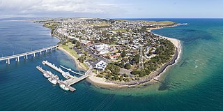
San Remo is a town in southern Victoria, Australia in the Gippsland region. Formed as a fishing village, its economy is now largely based on tourism. It is also notable as the town on the mainland end of the Phillip Island Bridge to Phillip Island. At the 2016 census, San Remo had a population of 1212.

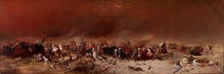
The city of Melbourne was founded in 1835. The exact circumstances of the foundation of Melbourne, and the question of who should take credit, have long been matters of dispute.

Between 1788 and 1868, about 162,000 convicts were transported from Britain and Ireland to various penal colonies in Australia.

William Lonsdale supervised the founding of the official settlement at Port Phillip from 1836 and went on to serve under the Superintendent La Trobe from 1839 to 1854.
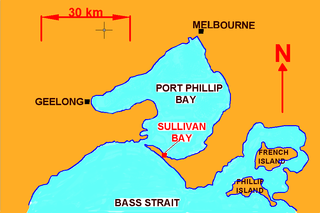
Sullivan Bay lies 60 km due south of Melbourne on Port Phillip, one kilometre east of Sorrento, Victoria. It was established as a short-lived convict settlement in 1803 by Lieutenant-Colonel David Collins, who named the bay after the Under-Secretary of State for War and the Colonies, John Sullivan.
The following lists events that happened during 1824 in Australia.

Corinella is a town in Victoria, Australia, located 114 km south-east of Melbourne via the M1 and the Bass Highway, on the eastern shore of Western Port.

The Moreton Bay Penal Settlement operated from 1825 to 1842. It became the city of Brisbane, Queensland, Australia.

The First Brisbane Burial Ground is a heritage-listed archaeological site at Skew Street, Brisbane City, City of Brisbane, Queensland, Australia. It is also known as Skew Street Cemetery. It was established in 1825 as part of the Moreton Bay penal settlement. It was added to the Queensland Heritage Register on 16 July 2010.

European land exploration of Australia deals with the opening up of the interior of Australia to European settlement which occurred gradually throughout the colonial period, 1788–1900. A number of these explorers are very well known, such as Burke and Wills who are well known for their failed attempt to cross the interior of Australia, as well as Hamilton Hume and Charles Sturt.

The European exploration of Australia first began in February 1606, when Dutch navigator Willem Janszoon landed in Cape York Peninsula and on October that year when Spanish explorer Luís Vaz de Torres sailed through, and navigated, Torres Strait islands. Twenty-nine other Dutch navigators explored the western and southern coasts in the 17th century, and dubbed the continent New Holland.

The Gurdies is a village located in Bass Coast Shire in Victoria, Australia.

