
The Shire of East Gippsland is a local government area in Gippsland, Victoria, Australia, located in the eastern part of the state. It covers an area of 20,940 square kilometres (8,080 sq mi) and as of the 2021 census had a population of 48,715.

The City of Melville is a local government area in the southern suburbs of the Western Australian capital city of Perth, east of the port city of Fremantle and about 12 kilometres (7.5 mi) south of Perth's central business district. The City covers an area of 52.73 square kilometres (20.36 sq mi) and had a population of about 98,000 as at the 2016 Census.
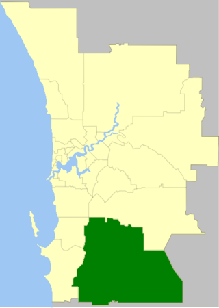
The Shire of Serpentine-Jarrahdale is a local government area in the outer southeastern metropolitan area of Perth, the capital of Western Australia, and has an area of 905 square kilometres (349 sq mi) and a population of 32,173 as at the 2021 Census. Despite being named after two towns in the area, neither Serpentine nor Jarrahdale function as either the Shire's largest settlement (Byford) or the seat of government (Mundijong).

The City of Mount Isa is a local government area in north west Queensland. The City covers the urban locality of Mount Isa, the administrative centre, and surrounding area, sharing a boundary with the Northern Territory to the west.
Wakeley is a suburb of Sydney, in the state of New South Wales, Australia 34 kilometres west of the Sydney central business district and is the council seat in the local government area of the City of Fairfield. Wakeley is part of the Greater Western Sydney region. At the 2021 census, Wakeley has a population of 4,893.

Woodbridge is a semi-rural locality in the local government area (LGA) of Kingborough in the Hobart LGA region of Tasmania. The locality is about 26 kilometres (16 mi) south of the town of Kingston. The 2021 Census recorded a population of 547 for the state suburb of Woodbridge, with the median age being 54. There are 180 families living in Woodbridge, with a mean of 1.8 children per household. It is located 38 kilometres (24 mi) south of the state capital, Hobart.

Athol Park is a north-western suburb of Adelaide, South Australia. It is located in the City of Charles Sturt.

Catherine Hill Bay is a coastal bay and village on the southern peninsula forming Lake Macquarie, south of the Pacific Ocean entrance channel at Swansea in New South Wales, Australia. It is part of the City of Lake Macquarie local government area. The village is the oldest continuous settlement in the City of Lake Macquarie. The Aboriginal people in this area, the Awabakal were the first people of this land.

Eungai is a town on the mid-North Coast of New South Wales, Australia. It is made up of two localities, Eungai Creek and Eungai Rail, although both have the same postcode. The Eungai district is midway between Sydney (500 km) and Brisbane, midway between Port Macquarie (90 km) and Coffs Harbour, and midway between Kempsey (20 km) and Macksville. It is in the Nambucca Valley. It has a population of 605 in the 2021 census.

Melrose Park is a suburb of Adelaide, South Australia in the City of Mitcham. It is bordered by South Road, Daws Road, Winston Avenue and Edward Street. Until 1989, Melrose Park was part of the suburb of Edwardstown. The name change occurred as the suburb was quite large, located on either side of South Road and was in the jurisdiction of two local government councils, with the larger western side belonging to the City of Marion. The suburb was named after early South Australian aviator, Charles James Melrose.

Collingullie is a village 26 kilometres (16 mi) north-west of Wagga Wagga in the Riverina region of New South Wales, Australia. The village is located on the Sturt Highway, between Wagga Wagga and Narrandera, at the crossroads with the road to Lockhart.
Coes Creek is a rural locality in the Sunshine Coast Region, Queensland, Australia. In the 2021 census, Coes Creek had a population of 1,515 people.

The Shire of Tammin is a local government area in the Wheatbelt region of Western Australia. Its seat of government is the town of Tammin, about 80 kilometres (50 mi) west of Merredin and about 180 kilometres (112 mi) east of Perth, the state capital.
Paddys River is a locality in the Southern Highlands of New South Wales, Australia, in Wingecarribee Shire. The locality was previously known as Murrimba. It is south of Canyonleigh.
Paralowie is a suburb in the north of Adelaide, South Australia, 21.4 km (13.3 mi) north of the Adelaide city centre. It is predominantly a residential suburb.
Flagstaff is a locality in Victoria, Australia, site of a former settlement, located on the Pyrenees Highway east of Maryborough in the Shire of Central Goldfields. 218 metres above sea level, the area is naturally characterised by Box-Ironbark forest. Remnants of aboriginal settlement include rock wells and aboriginal sculptures.
The 2016 Australian census was the 17th national population census held in Australia. The census was officially conducted with effect on Tuesday, 9 August 2016. The total population of the Commonwealth of Australia was counted as 23,401,892 – an increase of 8.8 per cent or 1,894,175 people over the 2011 census. Norfolk Island joined the census for the first time in 2016, adding 1,748 to the population.
Carbine Creek is a rural locality in the Central Highlands Region, Queensland, Australia. At the 2021 census, Carbine Creek had a population of 33 people.
Tabbil Creek is a small country town located between Dungog and Maitland in the Hunter Region of Australia. Tabbil Creek had a population of 53 people in the 2021 Census. Tabbil Creek includes a cemetery and a golf club.

