
The Bass Coast Shire is a local government area in Victoria, Australia, located in the southeastern part of the state. It covers an area of 866 square kilometres (334 sq mi) and in June 2018 had a population of 35,327. It includes the towns of Bass, Cape Paterson, Cape Woolamai, Corinella, Coronet Bay, Cowes, Inverloch, Kilcunda, Lang Lang, Newhaven, Rhyll, San Remo, Summerlands and Wonthaggi as well as the historic locality of Krowera. It also includes the popular tourist destination Phillip Island. It was formed in 1994 from the amalgamation of the Shire of Bass, Shire of Phillip Island, Borough of Wonthaggi, parts of the Shire of Woorayl, Shire of Korumburra and City of Cranbourne.

The Shire of South Gippsland is a local government area in Victoria, Australia, located in the south-eastern part of the state. It covers an area of 3,296 square kilometres (1,273 sq mi) and, in June 2018, had a population of 29,576.
The Bass Highway is an 87 kilometre highway in Victoria, Australia, branching off the South Gippsland Highway at the township of Lang Lang and running south, along the eastern shore of Western Port, to Anderson. The Bass Highway continues easterly to Kilcunda, Wonthaggi and Inverloch, then turns north-easterly to rejoin the South Gippsland Highway at Leongatha. It was named due to its proximity to the Bass Strait.

Inverloch is a seaside town in Victoria, Australia. It is 143 kilometres (89 mi) south east of Melbourne via the South Gippsland Highway on the Bass Highway in the Bass Coast Shire of Gippsland. Known originally for the calm waters of Anderson Inlet, it is now also known for the discovery of Australia's first dinosaur bone.

Korumburra is a town in the Australian state of Victoria. It is located on the South Gippsland Highway, 120 kilometres (75 mi) south-east of Melbourne, in the South Gippsland Shire local government area. At the 2016 census Korumburra had an urban population of 3,639.

Leongatha is a town in the foothills of the Strzelecki Ranges, South Gippsland Shire, Victoria, Australia, located 135 kilometres (84 mi) south-east of Melbourne. At the 2021 census, Leongatha had a population of 5,869.

Foster is a dairying and grazing town 174 kilometres (108 mi) south-east of Melbourne on the South Gippsland Highway in Victoria, Australia. At the 2016 census Foster had an urban population of 1,164. It is about 20 kilometres (12 mi) north of the Gippsland coastline which includes Shallow Inlet, Corner Inlet, Waratah Bay, Yanakie and Wilsons Promontory.
Langhorne Creek is a town in South Australia, located approximately 55 kilometres from the Adelaide city centre. At the 2021 census, Langhorne Creek had a population of 444 residents.

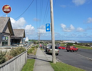
Cape Paterson is a cape and seaside village located near the town of Wonthaggi, 132 kilometres (82 mi) south-east of Melbourne via the South Gippsland and Bass Highways, in the Bass Coast Shire of Gippsland, Victoria, Australia. Known originally for the discovery of coal by William Hovell in 1826, it is now extremely popular for its beaches and rockpool and at the 2011 census, it had a population of 718.
Middle Beach is a small town in South Australia located about 40 kilometres northwest of the Adelaide city centre. It is located in the Adelaide Plains Council.

Dorrigo, a small town on the Waterfall Way, is located on the Northern Tablelands, in northern New South Wales, Australia. The town is part of Bellingen local government area.

Wilmington is a town and locality in the Yorke and Mid North region of South Australia.The town is located in the District Council of Mount Remarkable local government area, 305 kilometres (190 mi) north of the state capital, Adelaide.

The Shire of Bass was a local government area about 120 kilometres (75 mi) south-southeast of Melbourne, the state capital of Victoria, Australia. The shire covered an area of 526 square kilometres (203.1 sq mi), and existed from 1871 until 1994.
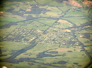
Nyora is a town in South Gippsland, Victoria, Australia, approximately 84 kilometres (52 mi) south-east of Melbourne's Central Business District, located within the Shires of Baw Baw, Cardinia and South Gippsland local government areas. Nyora recorded a population of 1,644 at the 2021 census.

The Shire of Woorayl was a local government area about 130 kilometres (81 mi) southeast of Melbourne, the state capital of Victoria, Australia. The shire covered an area of 1,245.79 square kilometres (481.0 sq mi), and existed from 1888 until 1994.
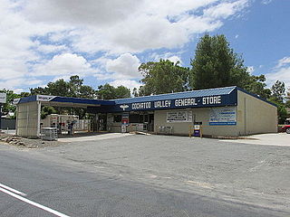
Cockatoo Valley is a locality in the Australian state of South Australia located about 41 kilometres (25 mi) north-east of the state capital of Adelaide and about 22 kilometres (14 mi) south-west of the municipal seat of Nuriootpa.
Pekina is a town and locality in the Mid North region of South Australia. The town is located in the District Council of Orroroo Carrieton local government area, 270 kilometres (170 mi) north of the state capital, Adelaide.

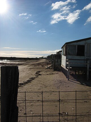
Dalyston is a seaside town located 125 kilometres (78 mi) south east of Melbourne via the South Gippsland and Bass Highways, in the Bass Coast Shire of Gippsland, Victoria, Australia. Known originally as a train station at Powlett River near Wonthaggi, it is now the location of the Victorian Desalination Plant, and at the 2011 census, it had a population of 606. It's Bass Coast’s fastest-growing suburb, with the 2011 census showing Dalyston’s population more than doubled from 278 residents in 2006 to 606 in 2011.
Racecourse Bay is a locality in the Australian state of South Australia located on the state’s south-east coast overlooking the body of water known in Australia as the Southern Ocean and by international authorities as the Great Australian Bight. It is about 398 kilometres south-east of the state capital of Adelaide and 25 kilometres south of the municipal seat of Mount Gambier in the south-east of the state.
Wattle Range is a locality in the Australian state of South Australia located in the state’s south-east about 328 kilometres (204 mi) south-east of the state capital of Adelaide and about 25 kilometres (16 mi) north-east of the municipal seat in Millicent.

