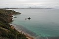
Cape Woolamai, Victoria

Last updated

Cape Woolamai
Victoria
Capewoolbeachrocks.JPG
The rocks and rockpools at Cape Woolamai Surf Beach
Australia Victoria Bass Coast Shire location map.svg
Red pog.svg
Cape Woolamai
Coordinates 38°31′40″S145°20′13″E / 38.52778°S 145.33694°E / -38.52778; 145.33694
Population1,676 (2016 census) [1]
Established1959
Postcode(s) 3925
Location140 km (87 mi) from Melbourne
LGA(s) Bass Coast Shire
State electorate(s) Bass
Federal division(s) Monash
Suburbs around Cape Woolamai:
Surf Beach Newhaven Newhaven
Bass Strait Cape Woolamai Western Port
Bass Strait Bass Strait Western Port

Cape Woolamai is a town and headland at the south eastern tip of Phillip Island in Victoria, Australia. It is home to Cape Woolamai State Faunal Reserve and the Phillip Island Airport. Cape Woolamai contains a subdivision also called Cape Woolamai (formerly known as Woolamai Waters and Woolamai Waters West).

Contents

History

The cape was named by George Bass (but spelt "Wollamai") when he passed it on his whaleboat voyage in early 1798. [2] [3] Wollamai is the snapper fish ( Pagrus auratus ) in the language of the Eora Aboriginal people of Port Jackson, where the fish is found. [4] Bass, who had learnt some of the Sydney language from the Eora leader Bennelong, [5] thought the headland resembled the head of that fish.

In 1826, during the establishment of Fort Dumaresq, near Rhyll, coal was reported to have been found in the vicinity of the Cape. [6] [7]

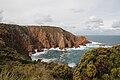
The area was purchased from the government in 1868 by John Cleeland, sea captain, publican and owner of the Melbourne Cup winner of 1875. He then built Wollomai House and ran merino sheep from New South Wales. In 1910 his son, John Blake Cleeland, noticed the sand was shifting due to erosion, so he planted rows of Marram grass, still evident today.
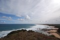
In 1959, 230 acres (0.93 km2) of farmland was sold and subdivided into housing estates for beach shacks and holiday makers. It was then named Woolamai Waters and Woolamai Waters West, and later renamed Cape Woolamai. Cape Woolamai had a Post Office from 1970 to roughly 1974 which was open only during summer. A Woolamai Post Office was open from 1911 until 1974. [8] The roads were sealed in the late 1980s and beach shacks gradually turned into more substantial houses. Today Cape Woolamai has a world-renowned surf beach, Woolamai Beach Surf Life Saving Club, and a popular Safety Beach.

Environment

The headland contains remnant vegetation and wildlife such as an important breeding colony of the short-tailed shearwater, also called the Australian muttonbird. [9] Volunteer groups such as the Cape Woolamai Coast Action Group conduct regular improvement and maintenance works including weed control and revegetation. [10] [11] It lies within the Phillip Island Important Bird Area, identified as such by BirdLife International because of its importance in supporting significant populations of little penguins, short-tailed shearwaters and Pacific gulls. [12] [13]

Related Research Articles

<span class="mw-page-title-main">Port Phillip</span> Bay in Victoria, Australia

Port Phillip or Port Phillip Bay is a horsehead-shaped enclosed bay on the central coast of southern Victoria, Australia. The bay opens into the Bass Strait via a short, narrow channel known as The Rip, and is completely surrounded by localities of Victoria's two largest cities — metropolitan Greater Melbourne in the bay's main eastern portion north of the Mornington Peninsula, and the city of Greater Geelong in the much smaller western portion north of the Bellarine Peninsula. Geographically, the bay covers 1,930 km2 (750 sq mi) and the shore stretches roughly 264 km (164 mi), with the volume of water around 25 km3 (6.0 cu mi). Most of the bay is navigable, although it is extremely shallow for its size — the deepest portion is only 24 m (79 ft) and half the bay is shallower than 8 m (26 ft). Its waters and coast are home to seals, whales, dolphins, corals and many kinds of seabirds and migratory waders.

<span class="mw-page-title-main">Phillip Island</span> Island in Victoria, Australia

Phillip Island is an Australian island about 125 km (78 mi) south-southeast of Melbourne, Victoria. The island is named after Governor Arthur Phillip, the first Governor of New South Wales, by explorer and seaman George Bass, who sailed in a whaleboat, arriving from Sydney on 5 January 1798.

<span class="mw-page-title-main">Bass Coast Shire</span> Local government area in Victoria, Australia

The Bass Coast Shire is a local government area in Victoria, Australia, located in the southeastern part of the state. It covers an area of 866 square kilometres (334 sq mi) and in June 2018 had a population of 35,327. It includes the towns of Bass, Cape Paterson, Cape Woolamai, Corinella, Coronet Bay, Cowes, Inverloch, Kilcunda, Lang Lang, Newhaven, Rhyll, San Remo, Summerlands and Wonthaggi as well as the historic locality of Krowera. It also includes the popular tourist destination Phillip Island. It was formed in 1994 from the amalgamation of the Shire of Bass, Shire of Phillip Island, Borough of Wonthaggi, parts of the Shire of Woorayl, Shire of Korumburra and City of Cranbourne.

<span class="mw-page-title-main">Bruny Island</span> Island off the coast of Tasmania

Bruny Island is a 362-square-kilometre (140 sq mi) island located off the southeastern coast of Tasmania, Australia. The island is separated from the Tasmanian mainland by the D'Entrecasteaux Channel, and its east coast lies within the Tasman Sea. Located to the island's northeast Storm Bay, is the river mouth to the Derwent River estuary, and serves as the main port of Hobart, Tasmania's capital city. Both the island and the channel are named after French explorer, Antoine Bruni d'Entrecasteaux. Its traditional Aboriginal name is lunawanna-allonah, which survives as the name of two island settlements, Alonnah and Lunawanna.

<span class="mw-page-title-main">Western Port</span> Bay in Victoria, Australia

Western Port, commonly but unofficially known as Western Port Bay, is a large tidal bay in southern Victoria, Australia, opening into Bass Strait. It is the second largest bay in the state. Geographically, it is dominated by two large islands; French Island and Phillip Island. At the time it was renamed, its position was west of other known ports and bays, but Western Port has become something of a misnomer as it lies just to the east of the larger Port Phillip and the city of Melbourne. It is visited by Australian fur seals, whales and dolphins, as well as many migratory waders and seabirds. It is listed under the Ramsar Convention as a wetland of international significance.

<span class="mw-page-title-main">Inverloch, Victoria</span> Town in Victoria, Australia

Inverloch is a seaside town in Victoria, Australia. It is 143 kilometres (89 mi) south east of Melbourne via the South Gippsland Highway on the Bass Highway in the Bass Coast Shire of Gippsland. Known originally for the calm waters of Anderson Inlet, it is now also known for the discovery of Australia's first dinosaur bone.

<span class="mw-page-title-main">Botany Bay</span> Open ocean bay in Sydney, Australia

Botany Bay is an open oceanic embayment, located in Sydney, New South Wales, Australia, 13 km (8 mi) south of the Sydney central business district. Its source is the confluence of the Georges River at Taren Point and San Souci as well as the Cooks River at Kyeemagh, which flows 10 km (6 mi) to the east before meeting its mouth at the Tasman Sea, midpoint between the suburbs of La Perouse and Kurnell. The northern headland of the entrance to the bay from the Tasman Sea is Cape Banks and, on the southern side, the outer headland is Cape Solander and the inner headland is Sutherland Point.

<span class="mw-page-title-main">Little Bay, New South Wales</span> Suburb of Sydney, New South Wales, Australia

Little Bay is a suburb in the Eastern Suburbs of Sydney, in the state of New South Wales, Australia. Little Bay is located 14 kilometres south-east of the Sydney central business district and is part of the local government area of the City of Randwick.

<span class="mw-page-title-main">Barunguba / Montague Island</span> Protected area in New South Wales, Australia

Barunguba / Montague Island is a continental island contained within the Montague Island Nature Reserve, a protected nature reserve that is located offshore from the South Coast region of New South Wales, in eastern Australia. The nearest town located onshore from the 81-hectare (200-acre) reserve and island is Narooma, situated approximately 9 kilometres (5.6 mi) to the northwest.

<span class="mw-page-title-main">Muttonbirding</span>

Muttonbirding is the seasonal harvesting of the chicks of petrels, especially shearwater species, for food, oil and feathers by recreational or commercial hunters. Such hunting of petrels and other seabirds has occurred in various locations since prehistoric times, and there is evidence that many island populations have become extinct as a result. More recently ‘muttonbirding’ usually refers to the regulated and sustainable harvesting of shearwaters in Australia and New Zealand. These include the short-tailed shearwater, also known as the yolla or Australian muttonbird, in Bass Strait, Tasmania, as well as the sooty shearwater, also known as the titi or New Zealand muttonbird, on several small islands known as the Muttonbird Islands, scattered around Stewart Island in the far south of New Zealand.

<span class="mw-page-title-main">Cape Paterson</span> Town in Victoria, Australia

Cape Paterson is a cape and seaside village located near the town of Wonthaggi, 132 kilometres (82 mi) south-east of Melbourne via the South Gippsland and Bass Highways, in the Bass Coast Shire of Gippsland, Victoria, Australia. Known originally for the discovery of coal by William Hovell in 1826, it is now extremely popular for its beaches and rockpool and at the 2011 census, it had a population of 718.

<span class="mw-page-title-main">Trefoil Island</span> Island in Tasmania, Australia

Trefoil Island , officially known as titima / Trefoil Island, is an island with an area of 115.79 ha, in south-eastern Australia. It is part of Tasmania’s Trefoil Island Group, lying close to Cape Grim, Tasmania's most north-westerly point, in Bass Strait. It is owned by the Trefoil Island Aboriginal Cooperative and is home to an estimated 1.5 million breeding pairs of short-tailed shearwaters, which are subject to annual muttonbirding activities. Approval is required to visit.

<span class="mw-page-title-main">Shire of Phillip Island</span> Local government area in Victoria, Australia

The Shire of Phillip Island was a local government area in Western Port Bay, about 120 kilometres (75 mi) south of Melbourne, the state capital of Victoria, Australia. The shire covered an area of 101.05 square kilometres (39.0 sq mi), and existed from 1928 until 1994.

<span class="mw-page-title-main">Anderson Island (Tasmania)</span> Island in Tasmania, Australia

The Anderson Island, also known as Woody Island, part of the Tin Kettle Island Group of the Furneaux Group, is a 166-hectare (410-acre) granite island, located in Bass Strait, lying northeast of Tasmania, in south-eastern Australia. Anderson Island lies between Flinders and Cape Barren Islands and is partly a pastoral lease used for grazing sheep and cattle. The island is joined at low tide to nearby Little Anderson and Tin Kettle Islands by extensive intertidal mudflats. The island is supposed to be named after John Anderson, a sealer living on the island by 1842.

<span class="mw-page-title-main">Babel Island</span> Island in Tasmania, Australia

The Babel Island, part of the Babel Group within the Furneaux Group, is a 440-hectare (1,100-acre) granite island, located in Bass Strait, lying off the east coast of Flinders Island, Tasmania, south of Victoria, Australia. The privately owned island was named by Matthew Flinders from the noises made by the seabirds there.

<span class="mw-page-title-main">Betsey Island</span> Island in Tasmania, Australia

Betsey Island, along with the adjacent Little Betsey Island and Betsey Reef, forms a nature reserve with an area of 176 ha in south-eastern Australia. They are part of the Betsey Island Group, lying close to the south-eastern coast of Tasmania around the entrance to the River Derwent. It is classified as an Important Bird Area by BirdLife International; it is an important site for little penguins with an estimated 15,000 pairs breeding there, short-tailed shearwaters, and black-faced cormorants.

<span class="mw-page-title-main">Hibbs Pyramid</span> Island in Tasmania, Australia

The Hibbs Pyramid is a pyramidal dolerite island, located in the Indian Ocean, off the south western coast of Tasmania, Australia. The island is contained within the Southwest National Park, part of the Tasmanian Wilderness World Heritage Site.

<span class="mw-page-title-main">Broughton Island (New South Wales)</span> Protected area in New South Wales, Australia

Broughton Island is an island 14 km north-east of Port Stephens on the Mid North Coast of New South Wales, Australia. It is part of the Myall Lakes National Park.(map)

<span class="mw-page-title-main">Phillip Island Important Bird Area</span> Important Bird Area in Victoria, Australia

The Phillip Island Important Bird Area comprises a 20 km2 strip of coastline along the south and west coasts of Phillip Island, Victoria, in south-eastern Australia.

<span class="mw-page-title-main">Solitary Islands Marine Park</span> Marine protected area in New South Wales, Australia

Solitary Islands Marine Park (SIMP) is a marine park in New South Wales State waters, Australia. It adjoins the Solitary Islands Marine Reserve and was declared under the Marine Parks Act 1997 (NSW) in January 1998. Prior to this it was declared a marine reserve in 1991. The Park was one of the first declared in NSW and stretches along the northern NSW coast, from Muttonbird Island, Coffs Harbour, to Plover Island near Sandon River, 75 kilometres to the north. It includes coastal estuaries and lakes and extends from the mean high water mark, to three nautical miles out to sea, covering an area of around 72 000 hectares. There are five main islands in the Park, North Solitary Island, North West Solitary Island, South West Solitary Island, South Solitary Island and Split Solitary Island, as well as other significant outcrops such as Muttonbird Island and submerged reefs.

References

  1. Australian Bureau of Statistics (27 June 2017). "Cape Woolamai (State Suburb)". 2016 Census QuickStats. Retrieved 1 October 2007. OOjs UI icon edit-ltr-progressive.svg
  2. "The Life of Captain Matthew Flinders R.N." gutenberg.net.au. Retrieved 17 December 2023.
  3. Australian Aboriginal words in English, R. M. W. Dixon, Oxford University Press, 1990, ISBN   0-19-553099-3
  4. Miriam Estensen, The Life of George Bass, Allen and Unwin, 2005, ISBN   1-74114-130-3
  5. "Classified Advertising". The Sydney Gazette and New South Wales Advertiser (NSW : 1803 - 1842) . NSW: National Library of Australia. 13 January 1827. p. 1. Retrieved 19 September 2013.
  6. "PROPOSED STEAMER BETWEEN VAN DIEMEN'S LAND AND PORT PHILLIP". The Hobart Town Courier (Tas. : 1827 - 1839) . Tas.: National Library of Australia. 4 May 1838. p. 3. Retrieved 19 September 2013.
  7. Phoenix Auctions History, Post Office List , retrieved 2 March 2021
  8. "Cape Woolamai Coastal Walk, The Pinnacles - Humble Trail". humbletrail.com. 9 January 2017. Retrieved 17 December 2023.
  9. "Weed mapping at Cape Woolamai". The Phillip Island and San Remo Advertiser. 7 September 2022. Retrieved 17 December 2023.
  10. "BASS COAST'S WILDLIFE CORRIDORS PRESERVING THE ENVIRONMENT AND ECONOMY". issuu. Retrieved 17 December 2023.
  11. "IBA: Phillip Island". Birdata. Birds Australia. Archived from the original on 6 July 2011. Retrieved 17 September 2011.
  12. The complete guide to finding the birds of Australia (2nd ed.). Collingwood: CSIRO. 2011. p. 9. ISBN   978-0-643-09785-8.