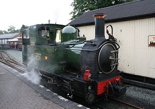
The Welshpool & Llanfair Light Railway (W&LLR) is a 2 ft 6 in narrow gauge heritage railway in Powys, Wales. The line is around 8.5 miles (13.7 km) long and runs westwards from the town of Welshpool via Castle Caereinion to the village of Llanfair Caereinion.

Montgomeryshire, also known as Maldwyn is one of thirteen historic counties and a former administrative county of Wales. It is named after its county town, Montgomery, which in turn is named after one of William the Conqueror's main counsellors, Roger de Montgomerie, who was the 1st Earl of Shrewsbury.

Katanning is a town located 277 kilometres (172 mi) south-east of Perth, Western Australia on the Great Southern Highway. At the 2016 census, Katanning had a population of 3,687.

Welshpool is a market town and community in Wales, historically in the county of Montgomeryshire, but currently administered as part of the unitary authority of Powys. The town is four miles from the Wales–England border and low-lying on the River Severn; its Welsh language name Y Trallwng means "the marshy or sinking land". The community includes Cloddiau and Pool Quay.

The City of Canning is a local government area in the southeastern suburbs of the Western Australian capital city of Perth, about 10 kilometres (6 mi) southeast of Perth's central business district. The City covers an area of 64.8 square kilometres (25.0 sq mi) and had a population of approximately 90,000 as at the 2016 Census.
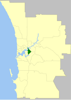
The Town of Victoria Park is a local government area of Western Australia. It covers an area of 17.62 km² in metropolitan Perth, the capital of Western Australia. It had a population of approximately 35,000 as at the 2016 Census.

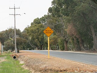
The township of Yarram is in Victoria, Australia, in the Shire of Wellington, located in the southeast of Gippsland. At the 2016 census, the population of the town was 2,135. The town is the regional centre of a prosperous farming district. It has a vibrant community, which remains dedicated to a strong sporting culture. The town also has a strong tourism industry, with Tarra Bulga National Park, Port Albert, Ninety Mile Beach and Agnes Falls all being within a 30-minute commute from Yarram. The town is located about one and a half hours from Wilsons Promontory. Nearby towns include Welshpool, Alberton and Foster.
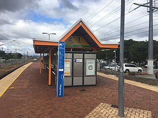
Welshpool Station is a railway station on the Transperth network. It is located on the Armadale/Thornlie Line, 9.5 kilometres from Perth Station serving the suburbs of Welshpool and Bentley, Western Australia.
Toora is a small farming town in Victoria, Australia whose main industry is dairy farming. It is located at the top of Corner Inlet opposite Wilsons Promontory National Park. In the 2016 census the population was 681.
The Mid Wales Football League is a football league in Wales at tier 4 of the Welsh Football pyramid, run by the Central Wales Football Association. The league consists of two regionally based divisions - an East Division and an West Division. The league offers a promotion route to the Football Association of Wales administered Tier 3 Ardal Leagues. Relegation is possible to the relevant tier 5 level leagues in Aberystwyth, Ceredigion, Mid Wales South and Powys.

Welshpool is an inner southeastern suburb of Perth, Western Australia, located mostly within the City of Canning and partially within the Town of Victoria Park.
East Cannington is a southeastern suburb of Perth, Western Australia. Its local government area is the City of Canning.

The Great Southern Rail Trail is a 68-kilometre rail trail from Leongatha to Welshpool in South Gippsland, Victoria, Australia. This mostly flat or gently undulating trail goes through lush dairy farmland, areas of remnant bush and lowland scrub. It climbs from the foothills of Fish Creek up past Mount Hoddle and then down a steep descent through dense forest out into magnificent views of Wilsons Promontory and Corner Inlet, continuing on to Foster. before ending at Welshpool.
Welshpool is a town in Wales, UK.

Lesmurdie is a suburb of Perth, Western Australia, located within the City of Kalamunda. It was established in 1897 by Archibald Sanderson, a politician and journalist, who began buying properties in the area from the Canning Jarrah Timber Company to build up a rural retreat and fruit-growing property. He named it after Lesmurdie Cottage, a shooting box near Dufftown, Scotland that his father had rented. It was officially gazetted on 8 June 1959.
Wattle Grove is a suburb of Perth, Western Australia, located within the City of Kalamunda.
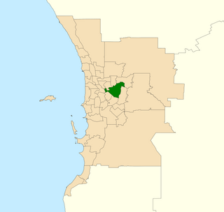
Belmont is an electoral district of the Legislative Assembly in the Australian state of Western Australia. Belmont is named for the inner eastern Perth suburb of Belmont, which falls within its borders.

The Welshpool Jetty railway was a 2 ft 6 in narrow gauge branch line in Victoria, Australia. It opened on 26 June 1905, and was operated as a horse-drawn tramway, connecting Welshpool station to Port Welshpool. It had a total length of just under 3.1 miles (5 km) and ran to the fishing jetty. The line closed on 1 January 1941.

Port Welshpool is a town in the South Gippsland region of Victoria, Australia. It is located 191 km south-east of Melbourne, on Corner Inlet and in 2006 had a population of 191.

Welshpool Llanerchyddol is the name of an electoral ward in the town of Welshpool, Powys, Wales. It elects a councillor to Powys County Council.
