
Esk is a rural town and locality in the Somerset Region in South East Queensland, Australia. In the 2021 census, the locality of Esk had a population of 1,641 people.

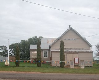
Neerim is a locality in Victoria, Australia, on Main Neerim Road in the Shire of Baw Baw.
Buckrabanyule is a locality in the north-central area of the state of Victoria in Australia. It is 237 kilometres (147 mi) from Melbourne, Victoria's capital city.

Kyalite is a locality on the Wakool River in the Riverina district of the Australian state of New South Wales. It is part of Balranald Shire and is approximately 890 kilometres (550 mi) south west of the state capital Sydney and 400 kilometres (250 mi) north west of Melbourne. Kyalite was formerly known as Wakool Crossing. At the 2021 census, Kyalite had a population of 87.
Woodville West is a suburb of Adelaide, situated about 9 kilometres northwest of the Central Business District. It lies within the City of Charles Sturt. The postcode of Woodville West is 5011. Woodville West is bounded by the railway line and Port Road in the north, Findon Road in the east, Trimmer Parade, Todville Street and Minns Street East in the south, and Frank Mitchell Park, Agnes Street and the railway line in the west. As of 2011, Renewal SA and the City of Charles Sturt have been implementing the Woodville West Neighbourhood Renewal Project, which involves an $130m property development.

Urangeline East is a rural community in the central part of the Riverina. It is situated by road, about 9 kilometres southeast from Urangeline and 19 kilometres east from Bidgeemia.
Stony Crossing is a locality in the south western part of the Riverina on the south bank of the Wakool River. By road, it is about 22 kilometres (14 mi) south east from Kyalite and 35 kilometres (22 mi) north west from Swan Hill.

Ceratodus is a rural town and locality in the North Burnett Region, Queensland, Australia. In the 2021 census, the locality of Ceratodus had a population of 34 people.

Ninda is a locality in Victoria, Australia, located approximately 13 km from Sea Lake, Victoria.
Nyarrin is a locality in Victoria, Australia, located approximately 59 km from Ouyen, Victoria.
Mundoo is a rural town and locality in the Cassowary Coast Region, Queensland, Australia. In the 2021 census, the locality of Mundoo had a population of 197 people.

Karara is a rural town and locality in the Southern Downs Region, Queensland, Australia. In the 2021 census, the locality of Karara had a population of 128 people.

Brooloo is a rural town and locality in the Gympie Region, Queensland, Australia. In the 2021 census, the locality of Brooloo had a population of 369 people.
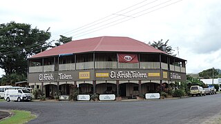
El Arish is a rural town and locality in the Cassowary Coast Region, Queensland, Australia. In the 2021 census, the locality of El Arish had a population of 337 people.

Moorabool is a locality of the City of Greater Geelong local government area in Victoria, Australia.
Marinna is a locality in Junee Shire in southern New South Wales, Australia. Its main feature is a grain silo on the Main South railway line. A station was opened in the locality between 1897 and 1975.
Watchupga is a locality in Northern Victoria, Australia. The local government area of Watchupga is the Shire of Buloke. Watchupga has a grain station on the Mildura railway line with a grain silo on the site which is 84 metres tall. However, the station was closed to passenger and parcels traffic on 11 November 1975. Watchupga Post Office opened on 23 July 1900 and was closed on 29 February 1972.

Chelona is a rural locality in the Mackay Region, Queensland, Australia. In the 2021 census, Chelona had a population of 120 people.
Hannaford is a rural locality in the Western Downs Region, Queensland, Australia. In the 2021 census, Hannaford had a population of 135 people.

Feluga is a rural locality in the Cassowary Coast Region, Queensland, Australia. In the 2021 census, Feluga had a population of 306 people.

