The Mitchell River National Park is a national park located in the Gippsland region of Victoria, Australia. The 14,250-hectare (35,200-acre) national park is situated approximately 320 kilometres (200 mi) east of Melbourne via the Princes Highway, and approximately 25 kilometres (16 mi) northwest of Bairnsdale. The northern portion of the park may be accessed via Dargo.

Bairnsdale is a city in East Gippsland, Victoria, Australia in a region traditionally owned by the Tatungalung clan of the Gunaikurnai people.

The Gippsland Lakes are a network of coastal lakes, marshes and lagoons in East Gippsland, Victoria, Australia covering an overall area of about 354 km2 (137 sq mi) between the rural towns of Lakes Entrance, Bairnsdale and Sale. The largest of the lakes are Lake Wellington, Lake King and Lake Victoria. The lakes are collectively fed by the Avon, Thomson, Latrobe, Mitchell, Nicholson and Tambo Rivers, and drain into the Bass Strait through a short canal about 2 km (1.2 mi) southwest of Lakes Entrance town centre.

Lakes Entrance is a seaside resort and fishing port in eastern Victoria, Australia. It is situated approximately 320 kilometres (200 mi) east of Melbourne, near a managed, artificial channel connecting the Gippsland Lakes to Bass Strait. At the 2016 census, Lakes Entrance had a population of 4,810.
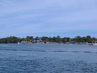
Paynesville is a tourist/holiday resort town in the Gippsland region of Victoria, Australia. At the 2016 census, Paynesville had a population of 3,480. The town is located 293 kilometres (182 mi) by road east of the state capital, Melbourne. It is known as the boating capital of Victoria.
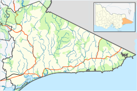
East Gippsland is the eastern region of Gippsland, Victoria, Australia covering 31,740 square kilometres (14%) of Victoria. It has a population of 80,114.

Bairnsdale railway station is the terminus of the Gippsland line in Victoria, Australia. It serves the city of Bairnsdale, and it opened on 8 May 1888.

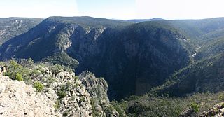
The Mitchell River is a perennial river of the East Gippsland catchment, located in the Australian state of Victoria. The unregulated river provides a unique example of riparian ecology, flowing generally south with the catchment area drawing from the steep mountains of the Victorian Alps to enter Lake King, one of the Gippsland Lakes, and then empty into the Bass Strait.

Bruthen is a small town located alongside the Tambo River between Bairnsdale and Ensay on the Great Alpine Road in East Gippsland, Victoria, Australia. At the 2016 census, Bruthen had a population of 814. Bruthen is 26 km (16 mi) east of Bairnsdale and 311 km (193 mi) east of the state capital Melbourne.

Stratford railway station is located on the Gippsland line in Victoria, Australia. It serves the town of Stratford, and it opened on 8 November 1887.

The Omeo and District Football League (ODFL) is an Australian rules football League based on the Omeo Region of East Gippsland, Victoria, Australia. The ODFL has existed in some form since 1893, and operates under the auspices of the Victorian Country Football League (VCFL). The league is situated in an area with a small population, resulting in the league playing 16-a-side rather than the standard 18-a-side, and not fielding a reserve grade.
The East Gippsland Football League is an Australian rules football League in the East Gippsland region of Victoria, Australia.
Swan Reach is a small residential town located in the east Gippsland region of Victoria. It is situated 306 kilometres (190 mi) east of the state capital, Melbourne and is located approximately halfway between the townships of Bairnsdale and Lakes Entrance on the Tambo River. Swan Reach falls under the jurisdiction of the Shire of East Gippsland local government area. According to the 2016 Australian Census Swan Reach and the surrounding area had a population of 751 people.
The City of Bairnsdale was a local government area about 280 kilometres (174 mi) east of Melbourne, the state capital of Victoria, Australia. The city covered an area of 27.20 square kilometres (10.5 sq mi), and existed from its split from the Shire of Bairnsdale in 1967 until 1994.
Johnsonville is a town in the East Gippsland region of Victoria, Australia. It is located on the Princes Highway 18.9 km east from the city of Bairnsdale and 18.3 km west from the tourist resort and fishing port of Lakes Entrance. The town encompasses an area of approximately 5,617 hectares, 56 square kilometres or 13,879 acres.

The Nicholson River is a perennial river of the Mitchell River catchment, located in the East Gippsland region of the Australian state of Victoria.
The Timbarra River is a perennial river of the Mitchell River catchment, located in the East Gippsland region of the Australian state of Victoria.
The Little River is a perennial river of the Snowy River catchment, located in the Alpine region of the Australian state of Victoria. It is one of two rivers of the same name that are tributaries of the Snowy River, the other being the Little River.
Eagle Point is a small town in Victoria, Australia within the Shire of East Gippsland on the Gippsland lakes, mostly on Lake King. It is known for its bushland and tourism. The top of the red limestone cliff by the Mitchell River offers unparalleled vista of the East Gippsland low country and Mitchell River silt jetties, stretching out for miles. Eagle Point is a place associated with the Bushy Park massacres of local Gunai Aboriginal people. 1840-41, Angus McMillan and his men killed an unknown number of Gunai people in skirmishes during "the defence of Bushy Park". Afterwards, in the mid to late 1840s, Eagle Point was the headquarters for the Border Police under Commissioner Tyers. This force in conjunction with the Native Police force based at nearby Boisdale conducted regular punitive raids upon Gunai camps across the region.
Wy Yung is a town in Victoria, Australia, located on Great Alpine Road, in the Shire of East Gippsland near Bairnsdale. The town's name means wild duck in the local indigenous language.