A request that this article title be changed to Suggan Buggan is under discussion . Please do not move this article until the discussion is closed. |
| Suggan Buggan Victoria | |
|---|---|
 This entirely wooden schoolhouse was built in 1865. | |
 Suggan Buggan | |
| Coordinates | 36°57′11″S148°19′33″E / 36.95306°S 148.32583°E |
| Population | 5 (2021 census) [1] |
| Postcode(s) | 3885 |
| Time zone | AEST (UTC+10) |
| • Summer (DST) | AEST (UTC+11) |
| LGA(s) | Shire of East Gippsland |
| State electorate(s) | Gippsland East |
| Federal division(s) | Division of Gippsland |
Suggan Buggan is a locality in the Shire of East Gippsland, Victoria, Australia. It is located on the border with New South Wales. [2] [3] At the 2021 census, Suggan Buggan had a population of 5. [1]
The traditional custodians of the area are the Australian Aboriginal Bidawal and Nindi-Ngudjam Ngarigu Monero peoples. [4] The name of the locality supposedly derives from the Aboriginal phrase "bukkan bukkan", which describes bags made from grass. [5]
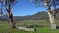
Suggan Buggan is surrounded by the Alpine National Park. There is a free camping area on the Suggan Buggan River. Several historical remains exist, including a well preserved 1860s wooden schoolhouse and an old house.