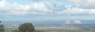
Traralgon is a city located in the east of the Latrobe Valley in the Gippsland region of Victoria, Australia and the most populous city in the City of Latrobe and the region. The urban population of Traralgon at the 2021 census was 26,907. It is the largest and fastest growing city in the greater Latrobe Valley area, which has a population of 77,168 at the 2021 Census and is administered by the City of Latrobe.

Bass Strait is a strait separating the island state of Tasmania from the Australian mainland. The strait provides the most direct waterway between the Great Australian Bight and the Tasman Sea, and is also the only maritime route into the economically prominent Port Phillip Bay.

Sale is a city situated in the Gippsland region of Victoria, Australia and the council capital of the Shire of Wellington. It had an estimated population of 15,305 in 2022 according to the Australian Bureau of Statistics. The total population including the immediate area around the town is approximately 19,000 according to shire website.

Morwell is a town in the Latrobe Valley area of Gippsland, in South-Eastern Victoria, Australia approximately 152 km (94 mi) east of Melbourne.

Gippsland is a rural region in the southeastern part of Victoria, Australia, mostly comprising the coastal plains south of the Victorian Alps. It covers an elongated area of 41,556 km2 (16,045 sq mi) east of the Shire of Cardinia between Dandenong Ranges and Mornington Peninsula, and is bounded to the north by the mountain ranges and plateaus/highlands of the High Country, to the southwest by the Western Port Bay, to the south and east by the Bass Strait and the Tasman Sea, and to the east and northeast by the Black–Allan Line.

The Gippsland Lakes are a network of coastal lakes, marshes and lagoons in East Gippsland, Victoria, Australia covering an overall area of about 354 km2 (137 sq mi) between the rural towns of Lakes Entrance, Bairnsdale and Sale. The largest of the lakes are Lake Wellington, Lake King and Lake Victoria. The lakes are collectively fed by the Avon, Thomson, Latrobe, Mitchell, Nicholson and Tambo Rivers, and drain into Bass Strait through a short canal about 2 km (1.2 mi) southwest of Lakes Entrance town centre.

The Avon River is a perennial river of the West Gippsland catchment, located in the West Gippsland region, of the Australian state of Victoria. The Avon, forms an important part of the Latrobe sub-catchment, draining the south eastern slopes of the Great Dividing Range, to form the Gippsland Lakes.
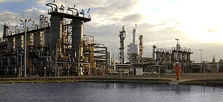
On 25 September 1998 a catastrophic accident occurred at the Esso natural gas plant in Longford, Victoria, Australia. A pressure vessel ruptured resulting in a serious jet fire, which escalated to a conflagration extending to a large part of the plant. Fires lasted two days before they were finally extinguished.

The Latrobe River is a perennial river of the West Gippsland catchment, located in the West Gippsland region of the Australian state of Victoria. The Latrobe River and its associated sub-catchment is an important source for the Gippsland Lakes, draining the south eastern slopes of the Great Dividing Range.
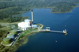
The Bell Bay Power Station was a power station located in Bell Bay, on the Tamar River, Tasmania, Australia, adjacent to the Tamar Valley Power Station, with which it was often confused. It was commissioned between 1971 and 1974 as an oil fired thermal power station, and was converted to natural gas in 2003, after the commissioning of the Tasmanian Gas Pipeline, a submarine gas pipeline which transports natural gas from Longford, Victoria, under Bass Strait, to Bell Bay, Tasmania. As the power station's primary role was to provide system security in the event of drought for Tasmania's predominantly hydro-electric based generation system it only was rarely called on to operate, resulting in intervals of five to eight years between periods of significant use. After the commissioning of Basslink in 2006, the power station was decommissioned in 2009.

The area known as Central Gippsland, also termed North Gippsland, is a region of Gippsland in Victoria, Australia, roughly corresponding to Shire of Wellington. Often this region is considered part of a larger "East Gippsland".
The Gas and Fuel Corporation of Victoria (G&FC) was a government-owned monopoly supplier of household gas in Victoria, Australia. It was established in 1950 and took over two of the three main gas utilities in Melbourne – the Metropolitan Gas Company and the Brighton Gas Company. As part of the conversion to natural gas, in 1971 the corporation acquired the Geelong Gas Company, one of only two remaining private gas companies in Victoria at the time. The Ballarat Gas Company closed at the time. The G&FC was wound up in June 1995.
ExxonMobil Australia is an Australian affiliate of ExxonMobil, the U.S.-based oil giant. It operates a number of oil and gas platforms in Bass Strait, south east of Melbourne, Australia, as well as a gas processing facility at Longford and Long Island Point (LIP) in Hastings.
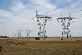
Energy in Victoria, Australia is generated using a number of fuels or technologies, including coal, natural gas and renewable energy sources. Brown coal, historically, was the main primary energy source for the generation of electricity in the state, accounting for about 85% of electricity generation in 2008. The amount of coal-fired power has decreased significantly with the closure in 2017 of the Hazelwood Power Station which supplied around 20% of Victoria's electricity, and to a lesser extent with the exit of Anglesea Power Station in 2015. Brown coal is one of the largest contributors to Australia's total domestic greenhouse gas emissions and a source of controversy for the country. Australia is one of the highest polluters of greenhouse gas per capita in the world.
The Sale Swing Bridge is located on Swing Bridge Drive near the South Gippsland Highway, Longford, 5 km south of the city of Sale, Victoria, Australia and spans the Latrobe River at its junction with the Thomson River.
Churchill is a town in the Latrobe Valley, located in central Gippsland in the east of Victoria, Australia. The town had a population of 4,568 at the 2016 census, and is part of the Latrobe City local government area. The town was named in honour of former British prime minister Sir Winston Churchill, who had died earlier in the year the town's establishment was announced.

The Darby River, a perennial river of the West Gippsland catchment, is located in the South Gippsland region of the Australian state of Victoria.
The Halibut Field is an oil field, within the Gippsland Basin offshore of the Australian state of Victoria. The oil field is located approximately 64 km offshore of southeastern Australia. The total area of this field is 26.9 km2 and is composed of 10 mappable units.
3. Glimpses of Longford by Deanna Gunning (2010)


