Jack River, Victoria

Last updated

Jack River
Victoria
Australia Victoria Wellington Shire location map.svg
Red pog.svg
Jack River
Coordinates 38°34′13″S146°33′14″E / 38.57028°S 146.55389°E / -38.57028; 146.55389 Coordinates: 38°34′13″S146°33′14″E / 38.57028°S 146.55389°E / -38.57028; 146.55389
Population 301 (2011 census) [1]
Postcode(s) 3971
Elevation 42 m (138 ft) [2]
Location
LGA(s) Shire of Wellington
State electorate(s) Gippsland South
Federal Division(s) Gippsland

Jack River (postcode: 3971) is a small settlement in the Shire of Wellington in southwestern Gippsland, in the Australian state of Victoria. The nearest major town is Yarram, located about 6 kilometres (3.7 mi) east. Jack River is located approximately 170 kilometres (110 mi) east southeast of Melbourne. [2]

Postcodes in Australia

Postcodes are used in Australia to more efficiently sort and route mail within the Australian postal system. Postcodes in Australia have four digits and are placed at the end of the Australian address. Postcodes were introduced in Australia in 1967 by the Postmaster-General's Department and are now managed by Australia Post, and are published in booklets available from post offices or online from the Australia Post website.

Shire of Wellington Local government area in Victoria, Australia

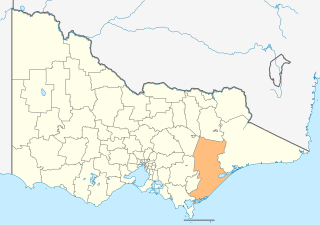
The Shire of Wellington is a local government area in Victoria, Australia, located in the eastern part of the state. It covers an area of 10,989 square kilometres (4,243 sq mi) and at the 2016 Census had a population of almost 43,000.

Gippsland Region in Victoria, Australia

Gippsland is an economic rural region of Victoria, Australia, located in the south-eastern part of that state. It covers an area of 41,556 square kilometres (16,045 sq mi), and lies to the east of the eastern suburbs of Greater Melbourne, to the north of Bass Strait, to the west of the Tasman Sea, to the south of the Black-Allan Line that marks part of the Victorian/New South Wales border, and to the east and southeast of the Great Dividing Range that lies within the Hume region and the Victorian Alps. Gippsland is generally broken down into the East Gippsland, South Gippsland, West Gippsland, and the Latrobe Valley statistical divisions.

At the 2011 census, Jack River had a population of 301. [1]

Related Research Articles

Mallee (Victoria) Region in Victoria, Australia

The Mallee is an ill-defined district, sometimes incorrectly referred to as an economic region, of the Australian state of Victoria. The district is located entirely within the Loddon Mallee region; and covers the most northwesterly district in the state bounded by the South Australian and New South Wales borders, inclusive of the Murray River.

Lockhart River, Queensland Town in Queensland, Australia

Lockhart River is a town in the Aboriginal Shire of Lockhart River and a locality split between the Aboriginal Shire of Lockhart River and the Shire of Cook, in Queensland, Australia. At the 2006 census, Lockhart River had a population of 542, which increased to 642 at the 2011 Census.

City of Albury Local government area in New South Wales, Australia

The City of Albury is a local government area in the Riverina region of New South Wales, Australia. The area covers 305.9 square kilometres (118.1 sq mi) to the north of the Murray River. The area extends around 10 to 12 kilometres east and west along the river from the centre of Albury and up to 20 kilometres (12 mi) north.

Cann River river of Gippsland in southeastern Victoria, Australia

The Cann River is a perennial river located in the East Gippsland region of the Australian state of Victoria.

Peechelba, Victoria Town in Victoria, Australia

Peechelba is a small town in north eastern Victoria, Australia. The town is located in the Rural City of Wangaratta and the Shire of Moira local government area between Wangaratta and Yarrawonga and 277 kilometres (172 mi) north west of the state capital, Melbourne. At the 2011 census, Peechelba and the surrounding area had a population of 345. The town is home to a nature reserve, not far from the Ovens River.

Timbarra River (Victoria) river in Victoria, Australia

The Timbarra River is a perennial river of the Mitchell River catchment, located in the East Gippsland region of the Australian state of Victoria.

Yeerung River river in Victoria, Australia

The Yeerung River is a perennial river located in the East Gippsland region of the Australian state of Victoria.

Brodribb River river in East Gippsland Shire, Victoria, Australia

The Brodribb River is a perennial river of the Snowy River catchment, located in the East Gippsland region of the Australian state of Victoria.

Cobungra River river in Australia

The Cobungra River, a perennial river of the North-East Murray catchment of the Murray-Darling basin, is located in the East Gippsland and alpine regions of Victoria, Australia.

Wentworth River (Victoria) river in Victoria, Australia

The Wentworth River is a perennial river of the Mitchell River catchment, located in the East Gippsland region of the Australian state of Victoria.

Jack River (Wellington, Victoria) tributary of the Albert River in Wellington, Victoria, Australia

The Jack River is a perennial river of the West Gippsland catchment, located in the Australian state of Victoria.

Jack River (East Gippsland, Victoria) tributary of the Brodribb River in East Gippsland, Victoria

The Jack River is a perennial river of the Snowy River catchment, located in the East Gippsland region of the Australian state of Victoria.

Rocky River (Victoria) river in Australia

The Rocky River is a perennial river of the Snowy River catchment, located in the East Gippsland region of the Australian state of Victoria.

Big River (Brodribb River, Victoria) river (tributary of the Brodribb River) in East Gippsland Shire, Victoria, Australia

The Big River is a perennial river of the Snowy River catchment, located in the East Gippsland region of the Australian state of Victoria.

Saint Patricks River river in Australia

The Saint Patricks River is a perennial river of the Snowy River catchment, located in the East Gippsland region of the Australian state of Victoria.

Rich River river

The Rich River is a perennial river of the Snowy River catchment, located in the East Gippsland region of the Australian state of Victoria.

Wonnangatta River river in Australia

The Wonnangatta River is a perennial river of the Mitchell River catchment, located in the Alpine and East Gippsland regions of the Australian state of Victoria.

Little Dargo River river in Australia

The Little Dargo River is a perennial river of the Mitchell River catchment, located in the Alpine region of the Australian state of Victoria.

Crooked River (Victoria) river in Australia

The Crooked River is a perennial river of the Mitchell River catchment, located in the Alpine region of the Australian state of Victoria.

Taponga River river in Australia

The Taponga River, an inland perennial river of the Goulburn Broken catchment, part of the Murray-Darling basin, is located in the lower South Eastern Highlands bioregion, alpine and Northern Country/North Central regions of the Australian state of Victoria. It flows from the northwestern slopes of the Australian Alps, north and joins with the Big River.

References

  1. 1 2 Australian Bureau of Statistics (31 October 2012). "Jack River (State Suburb)". 2011 Census QuickStats. Retrieved 12 January 2014. Blue pencil.svg
  2. 1 2 "Map of Jack River, VIC". Bonzle Digital Atlas of Australia. Retrieved 12 January 2014.