
Warragul is a town in Victoria, Australia, 102 kilometres south-east of Melbourne. Warragul lies between the Strzelecki Ranges to the south and the Mount Baw Baw Plateau of the Great Dividing Range to the north. As of the 2021 census, the town had a population of 19,856 people. Warragul forms part of a larger urban area that includes nearby Drouin that had an estimated total population of 42,827 as of the 2021 census.

The Shire of Baw Baw is a local government area in Victoria, Australia, in the eastern part of the state. It covers an area of 4,028 square kilometres (1,555 sq mi) and in 2021 had a population of 57,626.
Ashwood is a suburb in Melbourne, Victoria, Australia, 14 km south east of Melbourne's Central Business District, located within the City of Monash local government area. Ashwood recorded a population of 7,154 at the 2021 census.

Caulfield is a suburb in Melbourne, Victoria, Australia, 10 kilometres (6.2 mi) south-east of Melbourne's Central Business District, located within the City of Glen Eira local government area. Caulfield recorded a population of 5,748 at the 2021 census.

Carnegie is a suburb in Melbourne, Victoria, Australia, 12 km south-east of Melbourne's central business district, on the railway line between Caulfield and Oakleigh, located within the City of Glen Eira local government area. Carnegie recorded a population of 17,909 at the 2021 census.

Glen Huntly is a suburb in Melbourne, Victoria, Australia, 11 km south-east of Melbourne's Central Business District, located within the City of Glen Eira local government area. Glen Huntly recorded a population of 4,905 at the 2021 census.

Drouin is a town in the West Gippsland region, 90 kilometres (56 mi) east of Melbourne, in the Australian state of Victoria. Its local government area is the Shire of Baw Baw, and is home to the shire council's headquarters despite being the second-largest town in the shire, behind neighbouring Warragul. The town's name is believed to be derived from an Aboriginal word meaning "north wind". New housing developments have accelerated the town's residential growth in recent years. As at the 2016 census, Drouin had a population of 11,887 people.

Neerim South is a town in West Gippsland, Victoria, Australia, located in the Shire of Baw Baw, 110 kilometres (68 mi) east of Melbourne and 20 kilometres (12 mi) north of Warragul. At the 2021 census, Neerim South had a population of 1,599.
Neerim North is a locality in Victoria, Australia, located on Neerim North Road, in the Shire of Baw Baw.
Fumina South is a locality in Victoria, Australia. Located on Willowgrove Road, in the Shire of Baw Baw, it is an isolated pocket near the foothills of Mount Baw Baw. Fumina South has a population of approximately 50 people, mostly weekend farmers and retirees, although it was once a bustling community with its own post office and school.

Erica is a town in Victoria, Australia, on Rawson Road, in the Shire of Baw Baw.
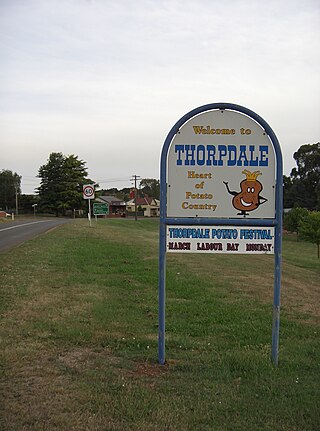
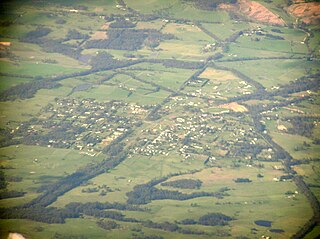
Thorpdale is a town in the Gippsland area of eastern Victoria in the Shire of Baw Baw. Famous for its potatoes, it is located amongst the rich farmland of the Latrobe Valley. Thorpdale spuds are eaten around the country and also exported overseas. The name "Thorpdale" means "village in a valley". The soil in the area is particularly rich as the town is located in a former volcanic crater. It is administered by the Shire of Baw Baw. At the 2006 census, Thorpdale and the surrounding area had a population of 447.

Rokeby is a town in West Gippsland, Victoria, Australia. It is near the towns of Warragul and Neerim South, 100 kilometres (62 mi) east of the state capital, Melbourne.

Longwarry is a town in Victoria, Australia, 83 kilometres (52 mi) south-east of Melbourne's Central Business District, located within the Shires of Baw Baw and Cardinia local government areas. Longwarry recorded a population of 2,436 at the 2021 census.
Nyora is a town in South Gippsland, Victoria, Australia, approximately 84 kilometres (52 mi) south-east of Melbourne's Central Business District, located within the Shires of Baw Baw, Cardinia and South Gippsland local government areas. Nyora recorded a population of 1,644 at the 2021 census.
The Noojee railway line is a closed railway line in Victoria, Australia. Branching off from the Gippsland line at Warragul station, it was built to service the timber industry in the upper Latrobe River area, transporting timber as well as providing a general goods and passenger service to townships in the area. The final section of the line between Neerim South and Noojee traversed increasingly hilly terrain and featured a number of large timber trestle bridges. Extensively and repeatedly damaged by bushfires over the years, the line was closed in the 1950s and dismantled. The last remaining large trestle bridge on the line has been preserved and has become a popular local tourist attraction.

Brooloo is a rural town and locality in the Gympie Region, Queensland, Australia. In the 2021 census, the locality of Brooloo had a population of 369 people.

Modella is a locality in Victoria, Australia, 77 kilometres (48 mi) south-east of Melbourne's central business district, located within the Shires of Baw Baw and Cardinia local government areas. Modella recorded a population of 169 at the 2021 census.
Watchupga is a locality in Northern Victoria, Australia. The local government area of Watchupga is the Shire of Buloke. Watchupga has a grain station on the Mildura railway line with a grain silo on the site which is 84 metres tall. However, the station was closed to passenger and parcels traffic on 11 November 1975. Watchupga Post Office opened on 23 July 1900 and was closed on 29 February 1972.
Coopers Creek is a locality and mine in the Gippsland region of Victoria, Australia. In the 1860s, Coopers Creek was settled during the Victorian gold rush and, throughout its history, gold, copper and lime have been mined there. Today, Coopers Creek is effectively limited to two camping sites, the first near the site of the mining town and the second to the east at Bruntons Bridge. Ruins from the locality's mining history, and the Copper Mine Hotel are all of the locality's history which survives. In August 2022, the 21 properties that comprise the town were listed for sale.


