Related Research Articles

The Baw Baw National Park is a national park located on the boundary between the Victorian Alps and Gippsland regions of Victoria, Australia. The 13,530-hectare (33,400-acre) national park is situated approximately 120 kilometres (75 mi) east of Melbourne and 50 kilometres (31 mi) north of the Latrobe Valley. The park contains the forest covered Baw-Baw Plateau and surrounds the Mount Baw Baw Alpine Resort.

Gippsland is a rural region that makes up the southeastern part of Victoria, Australia, mostly comprising the coastal plains to the rainward (southern) side of the Victorian Alps. It covers an elongated area of 41,556 km2 (16,045 sq mi) located further east of the Shire of Cardinia between Dandenong Ranges and Mornington Peninsula, and is bounded to the north by the mountain ranges and plateaus/highlands of the High Country, to the southwest by the Western Port Bay, to the south and east by the Bass Strait and the Tasman Sea, and to the east and northeast by the Black–Allan Line.

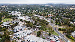
Warragul is a town in Victoria, Australia, 102 kilometres south-east of Melbourne. Warragul lies between the Strzelecki Ranges to the south and the Mount Baw Baw Plateau of the Great Dividing Range to the north. As of the 2021 census, the town had a population of 19,856 people. Warragul forms part of a larger urban area that includes nearby Drouin that had an estimated total population of 42,827 as of the 2021 census.
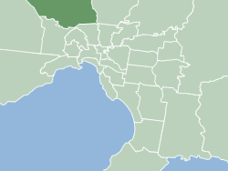
The Shire of Nillumbik is a local government area in Victoria, Australia. It contains outer northern suburbs of Melbourne and rural localities beyond the urban area. It has an area of 432 square kilometres and at the 2021 census, the Shire had a population of 62,895. It was formed in 1994 from the merger of parts of the Shires of Eltham, Diamond Valley, Healesville and the City of Whittlesea. The Shire uses the tag-line The Green Wedge Shire. The Nillumbik Council offices are located in Civic Drive, Greensborough.
The City of Hume is a local government area located within the metropolitan area of Melbourne, Victoria, Australia. It includes the outer north-western suburbs and a number of rural localities between 13 and 40 kilometres from the Melbourne city centre.

The City of Banyule is a local government area in Victoria, Australia in the north-eastern suburbs of Melbourne. It was created under the Local Government Act 1989 and established in 1994 as an amalgamation of former councils. It has an area of 63 square kilometres (24.3 sq mi) and lies between 7 and 21 km from central Melbourne. In 1994 it had a population of 116,000. In June 2018 Banyule had a population of 130,237. The Yarra River runs along the City's southern border while its western border is defined by Darebin Creek.
The Rural City of Horsham is a local government area in Victoria, Australia, located in the western part of the state. It covers an area of 4,267 square kilometres (1,647 sq mi) and in June 2018, had a population of 19,875. It includes the towns of Brimpaen, Dadswells Bridge, Dooen, Haven, Horsham, Laharum, Natimuk, Noradjuha and Pimpinio. It was formed in 1995 by the amalgamation of the City of Horsham, most of the Shire of Wimmera and Shire of Arapiles, and part of the Shire of Kowree.

The City of Warrnambool is a local government area in the Barwon South West region of Victoria, Australia, located in the south-western part of the state. It covers an area of 121 square kilometres (47 sq mi) and in June 2018 had a population of 34,862. It is entirely surrounded by the Shire of Moyne and the Southern Ocean. It is one of only a few regional councils in Victoria to remain serving just one urban district after the amalgamation process of 1994, although through that process it did gained some portions of the former Shire of Warrnambool.

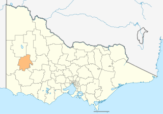
The Shire of Baw Baw is a local government area in Victoria, Australia, in the eastern part of the state. It covers an area of 4,028 square kilometres (1,555 sq mi) and in June 2018 had a population of 52,015.
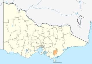
The City of Latrobe is a local government area in the Gippsland region in eastern Victoria, Australia, located in the eastern part of the state. It covers an area of 1,426 square kilometres (551 sq mi) and in June 2018 had a population of 75,211. It is primarily urban with the vast majority of its population living within the four major urban areas of Moe, Morwell, Traralgon, and Churchill, and other significant settlements in the LGA include Boolarra, Callignee, Glengarry, Jeeralang, Newborough, Toongabbie, Tyers, Yallourn North and Yinnar. It was formed in 1994 from the amalgamation of the City of Moe, City of Morwell, City of Traralgon, Shire of Traralgon, and parts of the Shire of Narracan and Shire of Rosedale. The Yallourn Works Area was added in 1996. When formed, the municipality was called the Shire of La Trobe, but on 6 April 2000, it adopted its current name.

The Shire of Mansfield is a local government area in the Hume region of Victoria, Australia, located in the north-east part of the state. It covers an area of 3,844 square kilometres (1,484 sq mi) and in August 2021, had a population of 10,178.
Mount Baw Baw is a mountain summit on the Baw-Baw Plateau of the Great Dividing Range, located in Victoria, Australia. The name is from the Woiwurrung language spoken by Eastern Kulin people. It is of uncertain meaning, but possibly signifies, echo, or ghost.

Drouin is a town in the West Gippsland region, 90 kilometres (56 mi) east of Melbourne, in the Australian state of Victoria. Its local government area is the Shire of Baw Baw, and is home to the shire council's headquarters despite being the second-largest town in the shire, behind neighbouring Warragul. The town's name is believed to be an Aboriginal word meaning "north wind". New housing developments have accelerated the town's residential growth in recent years. As at the 2016 census, Drouin had a population of 11,887 people.

Neerim South is a town in West Gippsland, Victoria, Australia, located in the Shire of Baw Baw, 110 kilometres (68 mi) east of Melbourne and 20 kilometres (12 mi) north of Warragul. At the 2021 census, Neerim South had a population of 1,599.

Erica is a town in Victoria, Australia, on Rawson Road, in the Shire of Baw Baw.
Nyora is a town in South Gippsland, Victoria, Australia, approximately 84 kilometres (52 mi) south-east of Melbourne's Central Business District, located within the Shires of Baw Baw, Cardinia and South Gippsland local government areas. Nyora recorded a population of 1,644 at the 2021 census.

The Rural City of Warragul was a local government area about 100 kilometres (62 mi) east-southeast of Melbourne, the state capital of Victoria, Australia. The rural city covered an area of 352.2 square kilometres (136.0 sq mi), and existed from 1881 until 1994.
The Macedon Ranges is a region in Central Victoria, known for its expansive native forests, vibrant arts scene, thriving food and wine industries and natural attractions such as Hanging Rock and Mount Macedon. It is located in between the cities of Bendigo and Melbourne. It includes the towns of Clarkefield, Gisborne South, Gisborne, Kyneton, Lancefield, Macedon, Malmsbury, Mount Macedon, New Gisborne, Riddells Creek, Romsey and Woodend. It is governed and administered by the Macedon Ranges Shire Council.

The Division of Monash is an Australian Electoral Division in the state of Victoria, which was contested for the first time at the 2019 federal election.

Neerim Junction is a town in West Gippsland, Victoria, Australia, located in the Shire of Baw Baw, 89 kilometres (55 mi) from Melbourne and 26 kilometres (16 mi) from Warragul. At the 2016 Census, Neerim Junction had a population of 127. Its postcode is 3832 and its Main Street hosts a general store with an Australia Post office, a small playground and a petrol station. It is one of several Neerim settlements, the others being Neerim South, Neerim North, Neerim and Neerim East.
References
- ↑ "Discover Baw Baw Shire Ferndale (VIC) Community Directory". www.mycommunitydirectory.com.au. Retrieved 2023-05-16.
- ↑ "Ferndale". Victoria. Retrieved 2023-05-16.
- ↑ "2021 Ferndale (Vic.), Census All persons QuickStats | Australian Bureau of Statistics". abs.gov.au. Retrieved 2023-05-16.