
Kayenta is a U.S. census-designated place (CDP) which is part of the Navajo Nation and is in Navajo County, Arizona, United States. The population was 5,189 at the 2010 census. Kayenta is located 25 miles (40 km) south of Monument Valley and contains a number of hotels and motels which serve visitors to Monument Valley. Like other places on the Navajo Nation, it is illegal to serve alcohol. Arizona does not observe Daylight Time; however, the Navajo reservation does.

Brooklyn is a town in the state of New South Wales, Australia, in the local government area of Hornsby Shire with a population of 722 as of the 2016 census. Brooklyn is surrounded by the Muogamarra Nature Reserve and occupies a strip of waterfront along the southern bank of the Hawkesbury River.

Arno Bay is a small fishing and tourist town on the east coast of Eyre Peninsula in South Australia, located on the Lincoln Highway about halfway between Whyalla and Port Lincoln. First proclaimed under the name Bligh in 1883, the current name dates back to 1940. It is a recreational town with a number of marine and nature based attractions, including fishing, surfing and swimming.

Broulee is a town on the south coast of New South Wales between Batemans Bay and Moruya. At the 2016 census, the town had a population of 1,717. Just off the beach is Broulee Island, currently joined to the mainland, but in past years the connecting spit has been covered by water, at times a very deep navigable channel with a strong current.

Scamander is a small town at the mouth of the Scamander River between St Helens and St Marys on the north-east coast of Tasmania in Australia. The town is a popular holiday destination because of its wide, sandy beaches and views of the ocean. Recreational activities include surfing, swimming and fishing for bream in the river.

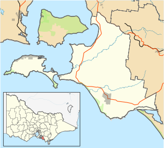
Birregurra is a town on Gulidjan Country in Victoria, Australia approximately 130 kilometres (81 mi) south-west of Melbourne. The town is divided between the Shire of Colac Otway and the Surf Coast Shire. At the 2016 census, Birregurra had a population of 828.

Streaky Bay is a coastal town on the western side of the Eyre Peninsula, in South Australia just off the Flinders Highway 303 km north west of Port Lincoln and 727 km by road from Adelaide. At the 2011 census, Streaky Bay recorded a population of 1,625.
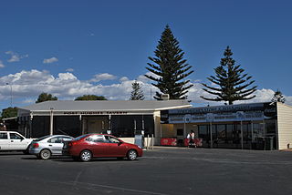
Port Hughes is a town and locality in the Australian state of South Australia located on northern Yorke Peninsula about 135 kilometres (84 mi) north-west of the state capital of Adelaide. It is considered a satellite town of Moonta which is located directly to the east of Port Hughes. At the 2016 census, Port Hughes had a population of 571.
Summerland Point is a suburb of the Central Coast region of New South Wales, Australia, located on a peninsula extending northwards into Lake Macquarie. It is part of the Central Coast Council local government area. It was formerly known as Gwandalan West.

Lummi Island lies at the southwest corner of Whatcom County, Washington, United States, between the mainland part of the county and offshore San Juan County. The Lummi Indian Reservation is situated on a peninsula east of the island, but does not include Lummi Island. The island has a land area of 23.97 square kilometres and had a population of 822 as of the 2000 census. The population nearly doubles in summer when property owners from both Canada and the U.S. arrive for summer fun and relaxation.

Barooga is a border town in the Riverina region of New South Wales, Australia, located in the Berrigan Shire local government area. It is situated just north of the Murray River which forms the border with Victoria. Barooga's population at the 2016 census was 1,817.

Burketown is an isolated outback town and coastal locality in the Shire of Burke, Queensland, Australia. In the 2016 census the locality of Burketown had a population of 238 people.

Kettering is a coastal town on the D'Entrecasteaux Channel opposite Bruny Island, Tasmania, Australia. At the 2011 census, Kettering had a population of 984.
Balgowan is a small coastal town on the west coast of South Australia's Yorke Peninsula. It is located approximately 20 kilometres west of Maitland. Like other towns on popular with tourists on Yorke Peninsula, it has a large number of shacks, holiday houses, caravan facilities and a boat ramp. The population generally increases during peak holiday periods.

Smoky Bay is a town and locality located in the Australian state of South Australia on the west coast of the Eyre Peninsula. Previously used as a port, the town is now a residential settlement and popular tourist destination known for its recreational fishing, with a boat ramp and jetty located in the town.

Island Beach is a locality in the Australian state of South Australia overlooking Eastern Cove in Nepean Bay on the north-west coast of the Dudley Peninsula on Kangaroo Island about 121 kilometres from the state capital of Adelaide and about 21 kilometres from Penneshaw.

Burrill Lake is a small village on the Princes Highway in the South Coast region of New South Wales, Australia. It is a seaside suburb of the Milton-Ulladulla district, a part of the City of Shoalhaven local government area and surrounds the lake of the same name. In 2016, the population Burrill Lake has a population of 1,465. The name of the town is derived from an Aboriginal word meaning 'wallaby'.

Mylestom is a small town in New South Wales, Australia, located on the coast near the mouth of the Bellinger River. At the 2011 census, Mylestom had a population of 339.
Coronet Bay is a town in Victoria, Australia, located 114 km south-east of Melbourne via the M1 and the Bass Highway, on the eastern shore of Western Port Bay.

Garden Island is a locality in the Australian state of South Australia located in the Adelaide metropolitan area within the estuary of the Port Adelaide River about 15 kilometres north-west of the Adelaide city centre.

