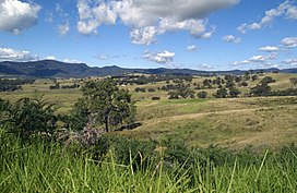
Lowland Grassy Woodland

Last updated

Lowland Grassy Woodland in the South East Corner
CSIRO ScienceImage 3372 Bega valley.jpg
Ecology
Realm Australasia
Biome Temperate grasslands, savannas, and shrublands
Borders Southern Highlands Shale Forest and Woodland, Illawarra-Shoalhaven subtropical rainforest and Australian Alps montane grasslands
Geography
Area0.1 km2 (0.039 sq mi)
CountryAustralia
Elevation10–500 metres (33–1,640 ft)
Coordinates 35°12′S150°26′E / 35.2°S 150.43°E / -35.2; 150.43 Coordinates: 35°12′S150°26′E / 35.2°S 150.43°E / -35.2; 150.43
Climate type Oceanic climate (Cfb)
Soil types Clay

The Lowland Grassy Woodland, or the Illawarra and South Coast Lowland Grassy Woodland is a grassland-savannah community mostly found in the South Coast region of New South Wales, Australia. Stretching from the southern parts of the Illawarra in the north to the South East Corner in the south, it is an endangered ecological community that lies in a rain shadow area. [1]

Contents

Geography

The community lies in an area that receives less rainfall than the elevated terrain that partly encircle them, with mean annual rainfall generally in the range of 700 to 1,100 mm (28 to 43 in). The community sits on granitic substrates (e.g. adamellites, granites, granodiorites, gabbros, etc.) but may also be found on locally precipitous sites and on acid volcanic, alluvial and fine-grained sedimentary substrates. They generally consist of an open tree canopy, a near-uninterrupted groundcover dominated by grasses and herbs, sometimes with stratums of shrubs and/or small trees. The bioregion incorporates: Bega Dry Grass Forest and Candelo Dry Grass Forest. [1]

The ecoregion is found in the Bega Valley, Eurobodalla and Palerang Local Government Areas, with major presence to the west of Batemans Bay, close to Moruya, in the Araluen valley, Cobargo, Candelo, the Towamba Valley and near Tanja. The remaining environment of the community is gravely fragmented, with more than 95% of surviving patches estimated to be less than 10 ha. [2]

Ecology

The grassy woodland is dominated by Eucalyptus tereticornis, Eucalyptus globoidea, Angophora floribunda, Eucalyptus melliodora, Eucalyptus pauciflora, Eucalyptus baueriana, Eucalyptus bosistoana, Eucalyptus maidenii and Eucalyptus viminalis. The understorey frequently features small trees like, Acacia mearnsii, Acacia implexa, Exocarpos cupressiformis and a shrub layer that features, Bursaria spinosa, Cassinia spp. and Ozothamnus diosmifolius. The groundcover features, Themeda australis, Microlaena stipoides and Eragrostis leptostachya, in addition to forbs such as Dichondra repens, Desmodium varians, Hydrocotyle laxiflora, Hypericum gramineum, Glycine clandestina and Cheilanthes sieberi. [3]

Animals

Inhabitants of the grassy woodlands include Macropus robustus, Macropus parma, Thylogale thetis, Bettongia gaimardi, Dasyurus viverrinus and Phascogale tapoatafa. [1]

Related Research Articles

<span class="mw-page-title-main">Illawarra</span> Region in New South Wales, Australia

The Illawarra is a coastal region in the Australian state of New South Wales, nestled between the mountains and the sea. It is situated immediately south of Sydney and north of the South Coast region. It encompasses the two cities of Wollongong, Shellharbour and the coastal town of Kiama. Wollongong is the largest city of the Illawarra with a population of 240,000, then Shellharbour with a population of 70,000 and Kiama with a population of 10,000. These three cities have their own suburbs. Wollongong stretches from Otford in the north to Windang in the south, with Maddens Plains and Cordeaux in the west.

<span class="mw-page-title-main">Avon Wheatbelt</span> Bioregion in Western Australia

The Avon Wheatbelt is a bioregion in Western Australia. It has an area of 9,517,104 hectares. It is considered part of the larger Southwest Australia savanna ecoregion.

<span class="mw-page-title-main">Eastern Australian temperate forests</span> Ecoregion in Australia

The Eastern Australian temperate forests is a broad ecoregion of open forest on uplands starting from the east coast of New South Wales in the South Coast to southern Queensland, Australia. Although dry sclerophyll and wet sclerophyll eucalyptus forests predominate within this ecoregion, a number of distinguishable rainforest communities are present as well.

<span class="mw-page-title-main">Southern Sydney sheltered forest</span>

The Southern Sydney sheltered forest is a vegetation community found in Sydney, Australia. An open forest composition grading into woodland or scrub, the community is normally associated with sheltered heads and upper inclines of gullies on transitional zones where sandstone outcropping may be present.

<span class="mw-page-title-main">Western Sydney Regional Park</span> Park in Sydney

Western Sydney Regional Park is a large urban park and a nature reserve situated in Western Sydney, Australia within the suburbs of Horsley Park and Abbotsbury. A precinct of Western Sydney Parklands, a park system, and situated within the heart of the Cumberland Plain Woodland, the regional park features several picnic areas, recreational facilities, equestrian trails, and walking paths within the Australian bush.

The Queanbeyan Nature Reserve is a protected nature reserve that is located in the Southern Tablelands region of New South Wales, in eastern Australia. The 67-hectare (170-acre) reserve is situated approximately 4 kilometres (2.5 mi) west-south-west of the City of Queanbeyan.

<span class="mw-page-title-main">Cumberland Plain Woodland</span> Indigenous woodland community in Sydney, Australia

The Cumberland Plain Woodland, or Western Sydney woodland, is a grassy woodland community found predominantly in Western Sydney, New South Wales, Australia, that comprises an open tree canopy, a groundcover with grasses and herbs, usually with layers of shrubs and/or small trees.

<span class="mw-page-title-main">Ecology of Sydney</span> Geographic aspect of Sydney, Australia

The ecology of Sydney, located in the state of New South Wales, Australia, is diverse for its size, where it would mainly feature biomes such as grassy woodlands and some sclerophyll forests, with a few pockets of mallee shrublands, subtropical and temperate rainforests (evergreen), heathlands, and wetlands. The combination of climate, topography, moisture, and soil influence the dispersion of these ecological communities across a height gradient from 0 to 200 metres. There are many hiking trails, paved and unpaved roads for exploring the many different biomes and ecosystems.

<span class="mw-page-title-main">Central Hunter Valley eucalypt forest and woodland</span> Endangered ecological community

The Central Hunter Valley eucalypt forest and woodland is a grassy woodland community situated in the Hunter Valley, New South Wales, Australia. It was listed in May 2015 as critically endangered under Australia’s national environment law. The Warkworth Sands Woodland of the Hunter Valley, situated in the area, was gazetted as an endangered ecological community in New South Wales on 13 December 2002 under the NSW Threatened Species Conservation Act 1995 and now under the Biodiversity Act of 2016.

<span class="mw-page-title-main">Gippsland Plains Grassy Woodland</span> Ecological community in southern Victoria

The Gippsland Plains Grassy Woodland is an ecological temperate grassland community located in the Gippsland region in southern Victoria, Australia. Stretching from Bairnsdale in the east to the eastern portion of Melbourne in the west, they typify one of Victoria's most threatened and disconnected indigenous ecosystems. The Gippsland Red Gum Grassy Woodland is the most prominent community in the system situated in the centre.

<span class="mw-page-title-main">Iron-grass Natural Temperate Grassland of South Australia</span> Ecological community in South Australia

The Iron-grass Natural Temperate Grassland of South Australia is a temperate grassland in the southeast of South Australia that stretches from Orroroo in the north, to Strathalbyn in the south, just straddling the eastern fringes of Adelaide's Mount Lofty Ranges. Listed as Critically Endangered under the EPBC Act, the grasslands predominantly feature Iron-grasses.

<span class="mw-page-title-main">New England Peppermint Grassy Woodland</span> Ecological community in New South Wales

The New England Peppermint Grassy Woodland is a grassy-woodland community primarily situated in the New England and Northern Tablelands regions in northern New South Wales, Australia. Named after the Eucalyptus nova-anglica, it is listed as a critically endangered ecological communities (TECs) under the Environment Protection and Biodiversity Conservation Act 1999 as it is one of the most significantly impacted ecoregion on the Northern Tablelands due to its fertile grazing land.

<span class="mw-page-title-main">Southern Highlands Shale Forest and Woodland</span> Ecological community in New South Wales

The Southern Highlands Shale Forest and Woodland is a mixed grassy woodland and sclerophyll-temperate forest community situated within the Southern Highlands region of New South Wales, Australia. An ecotone featuring clay soils derived from Wianamatta Group, it is listed as an endangered ecological community by the Environment Protection and Biodiversity Conservation Act 1999 as less than 5% of the original extent remains today. Three varieties of the Shale Woodland exist: ‘typical’, ‘tall wet’ and ‘short dry’.

<span class="mw-page-title-main">Shale Sandstone Transition Forest</span> Indigenous woodland community in Sydney, Australia

The Shale Sandstone Transition Forest, also known as Cumberland Shale-Sandstone Ironbark Forest, is a transitory ecotone between the grassy woodlands of the Cumberland Plain Woodlands and the dry sclerophyll forests of the sandstone plateaus on the edges of the Cumberland Plain in Sydney, Australia. Listed in 2001 under the Environment Protection and Biodiversity Conservation Act 1999, the forest lies between other ecological communities found on shale or sandstone substrates.

<span class="mw-page-title-main">Castlereagh Scribbly Gum and Agnes Banks Woodlands</span> Indigenous woodland community in Sydney, Australia

The Castlereagh Scribbly Gum and Agnes Banks Woodlands is an endangered sclerophyll woodland community found in western Sydney, New South Wales, Australia. Vegetation comprises low woodlands with sclerophyllous shrubs and an uneven ground layer of graminoids and forbs.

<span class="mw-page-title-main">Lowland Native Grasslands of Tasmania</span> Ecological community in southern Victoria

The Lowland Native Grasslands of Tasmania are a temperate grassland situated in the eastern portion of Tasmania, Australia. Listed as a critically endangered ecological community listed under the national environment law, they are dominated by kangaroo grass, velvet tussock grass and/or silver tussock grass.

<span class="mw-page-title-main">River-flat eucalypt forest</span>

The River-flat eucalypt forest or Coastal floodplain eucalypt forest is a critically endangered threatened ecological community that is primarily found in southeastern Australia, from southeastern Queensland, through New South Wales, to eastern Victoria, on alluvial soils of the coastal floodplains. The name chiefly refers to its riparian and floodplain landscape location and the predominant tree canopy being Eucalyptus, Angophora and/or Corymbia, which may exceed 40 m in height.

<span class="mw-page-title-main">Illawarra-Shoalhaven subtropical rainforest</span> Indigenous woodland community in Sydney, Australia

The Illawarra-Shoalhaven subtropical rainforest, or Illawarra Subtropical Rainforest (ISR), is a scattered rainforest community in the Illawarra region of New South Wales, Australia. Occurring just south of Sydney, it spans from the Royal National Park to the Milton-Ulladulla district in the south, albeit in scattered fragments.

References