Victoria Plains tropical savanna

Last updated

Victoria Plains tropical savanna
00 3169 Purnululu National Park - Western Australia.jpg
Purnululu National Park, Western Australia
Ecoregion AA0709.png
Ecoregion territory (in purple)
Ecology
Realm Australasian
Biome tropical and subtropical grasslands, savannas, and shrublands
Borders
Geography
Area223,982 km2 (86,480 sq mi)
Country Australia
States
Coordinates 16°40′S131°48′E / 16.67°S 131.8°E / -16.67; 131.8
Conservation
Conservation status Vulnerable
Protected16,001 km2 (7%) [1]

The Victoria Plains tropical savanna is a tropical and subtropical grasslands, savannas, and shrublands ecoregion in northwestern Australia. [2] [3] [4] [5]

Contents

Geography

The ecoregion lies in the central Northern Territory, extending into northeastern Western Australia. It forms a transition between the tropical savannas of northern Australia and the Australia's interior deserts. The Bungle Bungle Range is in the ecoregion. It is bounded on the northwest and north by the Kimberley tropical savanna, on the northeast and east by the Carpentaria tropical savanna, and on the southeast by the Mitchell Grass Downs. The Great Sandy-Tanami desert ecoregion lies to the south.

The western portion of the ecoregion, known as the Ord Victoria Plain, is drained by the upper Ord and Victoria rivers.

IBRA regions

The ecoregion encompasses the Ord Victoria Plain and Sturt Plateau IBRA regions.

Climate

The ecoregion has a tropical savanna climate. Monthly average maximum temperatures range from 25 to 35 °C (77 to 95 °F). The monsoon brings a summer wet season between November and March. The dry season extends for the rest of the year, and is nearly rainless. Rainfall generally decreases from north to south, ranging from 1200 mm per year in the north to 600 mm per year in the south. Some localized areas in the mountains experience higher rainfall. [2]

Flora

Woodlands with a grassy understorey, savanna, and grasslands are the predominant vegetation types. Pockets of dense lancewood-bullwaddy woodland with a sparse understorey are found in the eastern portion of the ecoregion. Plant communities vary with soils and rainfall.

Woodlands of eucalypts ( Eucalyptus spp.) and bloodwoods ( Corymbia spp.) are the most extensive plant community, usually found on sandy or loamy soils. The trees form a canopy 5 to 15 metres high. There is an understorey of tall grasses, including species of Sorghum, Heteropogon, Themeda, Chrysopogon, Aristida , and Eriachne . [2]

Open woodlands of Terminalia and Bauhinia species are found on fine-textured clay or clay-loam soils, as are grasslands with species of Astrebla, Iseilema, Chrysopogon, Aristida, and Dichanthium . [2]

Open woodland of eucalypts with an understorey of hummock grasses ( Triodia spp.) is found on sandstone outcrops and sandsheets derived from sandstones. Another sandstone plant community is heathland dominated by species of Grevillea and Acacia . [2]

Lancewood-bullwaddy woodland is a distinct plant community limited mostly to the ecoregion. These woodlands and thickets are mostly found on lateritic soils in the eastern Sturt Plateau, with a few scattered areas on lateritic outcrops further west. It is dominated by the trees lancewood (Acacia shirleyi) and bullwaddy (Macropteranthes kekwickii). Bullwaddy is a dry-season deciduous tree that grows up to six metres high, with small leaves growing on short branchlets. Lancewood-bullwaddy woodland is found only in the Northern Territory, concentrated mostly in the ecoregion and extending into adjacent ones. The woodlands have a dense tree canopy and can form impenetrable thickets, with many climbing vines and a sparser understorey of forbs, small shrubs, ferns, and mosses. The woodlands are more fire-sensitive, and less fire-prone, than the adjacent eucalyptus woodlands. These woodlands and thickets, like the monsoon forests of the adjacent Kimberley and Arnhem Land ecoregions, are refuges for many of the fire-sensitive species characteristic of Australia's rainforest flora. [2] [6]

Riparian forests grow in strips along rivers and streams, and include river red gum ( Eucalyptus camaldulensis ), Terminalia platyphylla, Nauclea orientalis , and species of Ficus, Melaleuca , and Pandanus . [2]

Fauna

Native mammals include the spectacled hare-wallaby (Lagorchestes conspicillatus), which is especially common in the lancewood-bullwaddy thickets, and the northern nailtail wallaby (Onychogalea unguifera) in grasslands and eucalypt woodlands. [2] Other native mammals include the agile wallaby (Macropus agilis), common wallaroo (Osphranter robustus), antilopine kangaroo (Osphranter antilopinus), short-beaked echidna (Tachyglossus aculeatus), common brushtail possum (Trichosurus vulpecula), rock-haunting ringtail possum (Petropseudes dahli), and sugar glider (Petaurus breviceps).

Three ground-foraging birds – the apostlebird (Struthidea cinerea), hooded robin (Melanodryas cucullata picata), and grey-crowned babbler (Pomatostomus temporalis rubeculus) – are associated with lancewood-bullwaddy woodlands and thickets. These bird species forage for invertebrates found in leaf litter and bare ground, which occur mostly in the lancewood-bullwaddy understorey and are seldom found elsewhere where tall grasses dominate the understorey. [6]

The black-tailed goanna (Varanus tristis) and giant frog (Ranoidea australis) are native to the ecoregion. [6]

Conservation and threats

Starting in the 1880s, large numbers of cattle were allowed to graze freely in the ecoregion, sustained by the ecoregion's lush grasslands and surface water supplies. By the 1930s intensive grazing by cattle and feral donkeys, together with increased late-dry-season bushfires, had degraded and large areas of the ecoregion's woodlands and grasslands, creating extensive barren areas and soil erosion. The Ord River Regeneration Reserve (ORRR) was established in 1960 to reduce soil erosion into the planned Lake Argyle. The project included contour cultivation and reseeding degraded and barren areas along the Ord River above the dam site. [7] Native species replanted included buffelgrass, birdwood grass, and kapok bush. [8] Cattle numbers were reduced and cattle grazing areas were contained with fences in the Ord River catchment, and the feral donkeys were culled. [9]

In 1987, The relatively intact area around the Bungle Bungle Range was gazetted as Purnulu National Park. [9]

Protected areas

A 2017 assessment found that 16,001 km2, or 7%, of the ecoregion is in protected areas. [1] Protected areas in the ecoregion include Purnululu National Park, Bullwaddy Conservation Reserve, Ord River Regeneration Reserve, and the eastern and southern portions of Judbarra National Park.

Related Research Articles

<span class="mw-page-title-main">Savanna</span> Mixed woodland-grassland ecosystem

A savanna or savannah is a mixed woodland-grassland ecosystem characterised by the trees being sufficiently widely spaced so that the canopy does not close. The open canopy allows sufficient light to reach the ground to support an unbroken herbaceous layer consisting primarily of grasses. According to Britannica, there exists four savanna forms; savanna woodland where trees and shrubs form a light canopy, tree savanna with scattered trees and shrubs, shrub savanna with distributed shrubs, and grass savanna where trees and shrubs are mostly nonexistent.

<span class="mw-page-title-main">Ord Victoria Plain</span> Bioregion in Australia

The Ord Victoria Plain, an interim Australian bioregion, is located in the Northern Territory and Western Australia, comprising 12,540,703 hectares.

<span class="mw-page-title-main">Geography of Western Australia</span>

Western Australia occupies nearly one third of the Australian continent. Due to the size and the isolation of the state, considerable emphasis has been made of these features; it is the second largest administrative territory in the world, after Yakutia in Russia, despite the fact that Australia is only the sixth largest country in the world by area, and no other regional administrative jurisdiction in the world occupies such a high percentage of a continental land mass. It is also the only first level administrative subdivision to occupy the entire continental coastline in one cardinal direction.

<span class="mw-page-title-main">Brigalow Belt</span> Ecoregion in Queensland, Australia

The Brigalow Belt is a wide band of acacia-wooded grassland that runs between tropical rainforest of the coast and the semi-arid interior of Queensland and northern New South Wales, Australia. The Interim Biogeographic Regionalisation for Australia (IBRA) divides the Brigalow Belt into two IBRA regions, or bioregions, Brigalow Belt North (BBN) and Brigalow Belt South (BBS). The North and South Brigalow Belt are two of the 85 bioregions across Australia and the 15 bioregions in Queensland. Together they form most of the Brigalow tropical savanna ecoregion.

<span class="mw-page-title-main">Arnhem Land tropical savanna</span> Ecoregion in Northern Territory, Australia

The Arnhem Land tropical savanna is a tropical and subtropical grasslands, savannas, and shrublands ecoregion in Australia's Northern Territory.

<span class="mw-page-title-main">Carpentaria tropical savanna</span> Ecoregion in Australia

The Carpentaria tropical savanna is a tropical and subtropical grasslands, savannas, and shrublands ecoregion in northern Australia.

<span class="mw-page-title-main">Kimberley tropical savanna</span> Terrestrial ecoregion in Western Australia

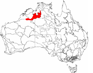
The Kimberley tropical savanna is a tropical and subtropical grasslands, savannas, and shrublands ecoregion in northwestern Australia, covering portions of Western Australia and the Northern Territory south of the Timor Sea.

<span class="mw-page-title-main">Pindan</span>

Pindan is a name given to the red-soil country of the south-western Kimberley region of Western Australia. The term comes from a local language and applies both to the soil and to the vegetation community associated with it.

<span class="mw-page-title-main">Southeast Australia temperate savanna</span>

The Southeast Australia temperate savanna ecoregion is a large area of grassland dotted with eucalyptus trees running north–south across central New South Wales, Australia.

<span class="mw-page-title-main">Coolgardie woodlands</span> Terrestrial ecoregion in Western Australia

The Coolgardie woodlands is an ecoregion in southern Western Australia. The predominant vegetation is woodlands and mallee scrub. The ecoregion is a transitional zone between the Mediterranean-climate forests, woodlands, and shrublands of Southwest Australia and the deserts and dry scrublands of the Australian interior.

<span class="mw-page-title-main">Ord River Floodplain</span> Floodplain in Australia

The Ord River floodplain is the floodplain of the lower Ord River in the Shire of Wyndham-East Kimberley, in the Kimberley region of northern Western Australia. It lies within the Victoria Bonaparte IBRA bioregion and contains river, seasonal creek, tidal mudflat and floodplain wetlands, with extensive stands of mangroves, that support saltwater crocodiles and many waterbirds. It is recognised as an internationally important wetland area, with 1,384 square kilometres (534 sq mi) of it designated on 7 June 1990 as Ramsar Site 477 under the Ramsar Convention on Wetlands.

<span class="mw-page-title-main">Western Sydney Regional Park</span> Park in Sydney

Western Sydney Regional Park is a large urban park and a nature reserve situated in Western Sydney, Australia within the suburbs of Horsley Park and Abbotsbury. A precinct of Western Sydney Parklands, a park system, and situated within the heart of the Cumberland Plain Woodland, the regional park features several picnic areas, recreational facilities, equestrian trails, and walking paths within the Australian bush.

<i>Macropteranthes kekwickii</i> Species of shrub

Macropteranthes kekwickii, commonly known as bullwaddy, is a species of woody tree or shrub native to the Northern Territory in Australia.

<span class="mw-page-title-main">Pilbara shrublands</span> Terrestrial ecoregion in Western Australia

The Pilbara shrublands is a deserts and xeric shrublands ecoregion in Western Australia. It is coterminous with the Pilbara IBRA region. For other definitions and uses of "Pilbara region" see Pilbara.

Southern <i>Acacia</i>–<i>Commiphora</i> bushlands and thickets

The Southern AcaciaCommiphora bushlands and thickets is a tropical grasslands, savannas, and shrublands ecoregion in Tanzania and Kenya. It includes portions of Serengeti National Park and Ngorongoro Conservation Area, which are designated World Heritage Sites and biosphere reserves for their outstanding wildlife and landscapes. It is one of three Acacia–Commiphora bushlands and thickets ecoregions in eastern Africa.

<span class="mw-page-title-main">Southeast Australia temperate forests</span> Terrestrial ecoregion in Australia

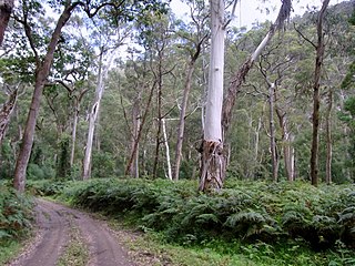
The Southeast Australia temperate forests is a temperate broadleaf and mixed forests ecoregion of south-eastern Australia. It includes the temperate lowland forests of southeastern Australia, at the southern end of the Great Dividing Range. Vegetation ranges from wet forests along the coast to dry forests and woodlands inland.

<span class="mw-page-title-main">Mitchell Grass Downs</span> Ecoregion in Australia

The Mitchell Grass Downs is a tropical and subtropical grasslands, savannas, and shrublands ecoregion in northeastern Australia. It is a mostly treeless grassland, characterised by Mitchell grasses .

<span class="mw-page-title-main">Tasmanian temperate forests</span> Ecoregion in Tasmania, Australia

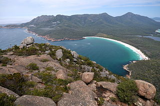
The Tasmanian temperate forests is a temperate broadleaf and mixed forests ecoregion in Australia. The ecoregion occupies the eastern portion of the island of Tasmania, which lies south of the Australian mainland.

<span class="mw-page-title-main">Shale Sandstone Transition Forest</span> Indigenous woodland community in Sydney, Australia

The Shale Sandstone Transition Forest, also known as Cumberland Shale-Sandstone Ironbark Forest, is a transitory ecotone between the grassy woodlands of the Cumberland Plain Woodlands and the dry sclerophyll forests of the sandstone plateaus on the edges of the Cumberland Plain in Sydney, Australia.

References

  1. 1 2 Eric Dinerstein, David Olson, et al. (2017). An Ecoregion-Based Approach to Protecting Half the Terrestrial Realm, BioScience, Volume 67, Issue 6, June 2017, Pages 534–545; Supplemental material 2 table S1b.
  2. 1 2 3 4 5 6 7 8 "Victoria Plains tropical savanna". Terrestrial Ecoregions. World Wildlife Fund.
  3. "Map of Ecoregions 2017". Resolve. Retrieved 20 August 2021.
  4. "Victoria Plains tropical savanna". Digital Observatory for Protected Areas. Retrieved 20 August 2021.
  5. "Victoria Plains tropical savanna". The Encyclopedia of Earth. Retrieved 20 August 2021.
  6. 1 2 3 Bullwaddy Conservation Reserve Plan of Management 2005. Parks and Wildlife Commission of the Northern Territory. ISBN N. 0 7245 4866 1 Accessed 22 October 2020.
  7. Stelle, Laurelle (15 January 2024). "Scientist shares remarkable before-and-after photos of a restored nature reserve: 'It's an incredible example'". Yahoo Life. Retrieved 15 January 2024.
  8. "Ord River Catchment Regeneration Project | Monument Australia". monumentaustralia.org.au. Retrieved 17 January 2024.
  9. 1 2 Payne, A L, Watson, I W, and Novelly, P E. (2004). Spectacular recovery in the Ord River catchment. Department of Agriculture and Food, Western Australia, Perth. Report 17/2004.