
Temperate grasslands, savannas, and shrublands is a terrestrial biome defined by the World Wide Fund for Nature. The predominant vegetation in this biome consists of grass and/or shrubs. The climate is temperate and ranges from semi-arid to semi-humid. The habitat type differs from tropical grasslands in the annual temperature regime as well as the types of species found here.

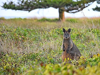
Synemon plana, commonly known as the golden sun moth, is a diurnal moth native to Australia and throughout its range, it is currently classified as vulnerable under the Environment Protection and Biodiversity Conservation Act 1999.
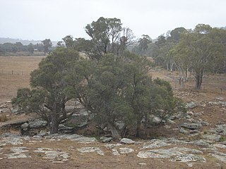
Scottsdale Reserve is a 1,328-hectare (3,280-acre) nature reserve on the Murrumbidgee River in south-central New South Wales, Australia. It is 79 kilometres (49 mi) south of Canberra, and 4 kilometres (2.5 mi) north of Bredbo. It is owned and managed by Bush Heritage Australia (BHA), which purchased it in 2006. The purchase was supportive of projects aiming to connect existing fragmented remnant habitat such as K2C. Since the 1870s up until 2006, the land was used for agriculture – primarily sheep grazing with some minor cropping. A significant component of the Reserve has been cleared of native vegetation.

Wingecarribee Swamp is a heritage-listed wetland at Illawarra Highway, Robertson, Wingecarribee Shire, New South Wales, Australia. It was added to the New South Wales State Heritage Register on 2 April 1999. It is also listed on the Directory of Important Wetlands in Australia and the former Register of the National Estate.

Western Sydney Regional Park is a large urban park and a nature reserve situated in Western Sydney, Australia within the suburbs of Horsley Park and Abbotsbury. A precinct of Western Sydney Parklands, a park system, and situated within the heart of the Cumberland Plain Woodland, the regional park features several picnic areas, recreational facilities, equestrian trails, and walking paths within the Australian bush.
The Queanbeyan Nature Reserve is a protected nature reserve that is located in the Southern Tablelands region of New South Wales, in eastern Australia. The 67-hectare (170-acre) reserve is situated approximately 4 kilometres (2.5 mi) west-south-west of the City of Queanbeyan.

The swamp communities of the Blue Mountains are a geographically dispersed group of ecologically-endangered peat swamp communities, spanning multiple parts of the World Heritage-listed Blue Mountains National Park in New South Wales, Australia.

Lomandra effusa is a perennial, dioecious, rhizomatous herb native to Australia. It is a perennial tussock with bluish green, large, arching leaves which are distinctive by the two toothed leaf tip. It has white, cream or pink fragrant flowers during the months of June to October.

The Cumberland Plain Woodland, also known as Cumberland Plain Bushland and Western Sydney woodland, is a grassy woodland community found predominantly in Western Sydney, New South Wales, Australia, that comprises an open tree canopy, a groundcover with grasses and herbs, usually with layers of shrubs and/or small trees.
The Victorian Volcanic Plain Grasslands are a critically endangered temperate grasslands that occur in the Australian state of Victoria, stretching from Hamilton in the northwest to the city of Melbourne. Part of the Southern Volcanic Plain and bordering the Gippsland Plains Grassy Woodland to the east, the grasslands sit on Cainozoic volcanic deposits. In 2011, the Victoria State Government had reserved 15,000 hectares of land to protect the critically endangered community. Only less than 5% of the pre-European concentration of the grasslands remain.

The Gippsland Plains Grassy Woodland is an ecological temperate grassland community located in the Gippsland region in southern Victoria, Australia. Stretching from Bairnsdale in the east to the eastern portion of Melbourne in the west, they typify one of Victoria's most threatened and disconnected indigenous ecosystems. The Gippsland Red Gum Grassy Woodland is the most prominent community in the system situated in the centre.

The Iron-grass Natural Temperate Grassland of South Australia is a temperate grassland in the southeast of South Australia that stretches from Orroroo in the north, to Strathalbyn in the south, just straddling the eastern fringes of Adelaide's Mount Lofty Ranges. Listed as Critically Endangered under the EPBC Act, the grasslands predominantly feature Iron-grasses.

The Northern Plains Grassland (NPGL) is an open, shrubby temperate grassland community located in northern Victoria straddling the Murray Darling Depression and Wimmera, extending to the Riverina and South Western Slopes regions in southern New South Wales. Floristically rich, the area features 30 native plant species per 100 m2.
The Southern Highlands Shale Forest and Woodland is a mixed grassy woodland and sclerophyll-temperate forest community situated within the Southern Highlands region of New South Wales, Australia. An ecotone featuring clay soils derived from Wianamatta Group, it is listed as an endangered ecological community by the Environment Protection and Biodiversity Conservation Act 1999 as less than 5% of the original extent remains today. Three varieties of the Shale Woodland exist: ‘typical’, ‘tall wet’ and ‘short dry’.

The Blue Mountains and Southern Highlands Basalt Forests are a sclerophyll temperate forest community that stretch from the northern fringes of the Blue Mountains to the Southern Highlands in New South Wales, Australia. Featuring both wet and dry sclerophyll forests, as well as small rainforest pockets, the community features tall (30m+) and open eucalypt forests and woodlands that lie on igneous rock.

The Lowland Grassy Woodland, or the Illawarra and South Coast Lowland Grassy Woodland is a grassland-savannah community mostly found in the South Coast region of New South Wales, Australia. Stretching from the southern parts of the Illawarra in the north to the South East Corner in the south, it is an endangered ecological community that lies in a rain shadow area.

The Lowland Native Grasslands of Tasmania are a temperate grassland situated in the eastern portion of Tasmania, Australia. Listed as a critically endangered ecological community listed under the national environment law, they are dominated by kangaroo grass, velvet tussock grass and/or silver tussock grass.

The River-flat eucalypt forest or Coastal floodplain eucalypt forest is a critically endangered threatened ecological community that is primarily found in southeastern Australia, from southeastern Queensland, through New South Wales, to eastern Victoria, on alluvial soils of the coastal floodplains. The name chiefly refers to its riparian and floodplain landscape location and the predominant tree canopy being Eucalyptus, Angophora and/or Corymbia, which may exceed 40 m in height.
